
A qanat or kārīz is a system for transporting water from an aquifer or water well to the surface, through an underground aqueduct; the system originated approximately 3,000 years ago in Iran. The function is essentially the same across North Africa and the Middle East but the system operates under a variety of regional names: qanat or kārīz in Iran, qanat in Malta, foggara in Algeria, khettara in Morocco, falaj in Oman and the United Arab Emirates, karez in Afghanistan and Pakistan, uyūn in Saudi Arabia, etc. The largest extant and functional qanat systems are located in Iran, Afghanistan, Oman, the oases of Turfan region of China, Algeria, and Pakistan.

Gonabad is a city in the Central District of Gonabad County, Razavi Khorasan Province, Iran, serving as capital of both the county and the district.

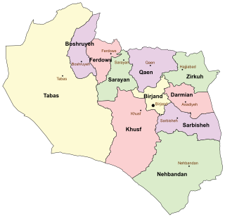
South Khorasan Province is one of the 31 provinces of Iran, located in the eastern part of the country. Its capital is the city of Birjand.

Zibad is a village in, and the capital of, Zibad Rural District, of Kakhk District, Gonabad County, Razavi Khorasan province, Iran.
A shabestan or shabistan is an underground space that can be usually found in traditional architecture of mosques, houses, and schools in ancient Iran.
Most rivers in Iran are seasonal and have traditionally not been able to supply the needs of urban settlements. Major rivers like the Arvand, Aras, Zayandeh, Sefid and Atrak were few and far between in Persia.

Ferdows is a city in the Central District of Ferdows County, South Khorasan province, Iran, serving as capital of both the county and the district. It is about 345 kilometres (214 mi) south of Mashhad and 200 km northwest of Birjand. Ferdous is located on the main axis connecting Yazd, Kerman, Isfahan, Bushehr, Hormozgan and Fars provinces to Mashhad. Ferdows city is 1293 meters above sea level.
Ferdows County is in South Khorasan province, Iran. Its capital is the city of Ferdows.
Eslamiyeh is a city in, and the capital of, Eslamiyeh District of Ferdows County, South Khorasan province, Iran.

Ferdows Garden is a historical complex located in the district of Tajrish in Shemiran, Iran.
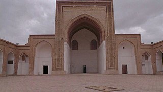
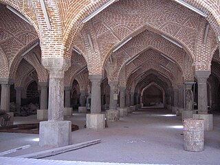
The Jāmeh Mosque of Ferdows is the congregational mosque (Jāmeh) of Ferdows, South Khorasan Province, Iran. The mosque is located towards the southwest of city, in the center of the city of Toon.
Safayyeh is a city in, and the capital of, Ferdows District of Rafsanjan County, Kerman province, Iran. It also serves as the administrative center for Ferdows Rural District.
Ferdows District is in Rafsanjan County, Kerman province, Iran. Its capital is the city of Safayyeh.
Ferdows is a village in, and the capital of, Ferdows Rural District of Esfandaqeh District, Jiroft County, Kerman province, Iran.
Ferdows Rural District is in Ferdows District of Rafsanjan County, Kerman province, Iran. It is administered from the city of Safayyeh.
Qanat Tir is a village in Chahar Gonbad Rural District, in the Central District of Sirjan County, Kerman Province, Iran. At the 2006 census, its population was 27, in 6 families.
Qanat Ebrahim is a village in, and the capital of, Arzhang Rural District of Bagh Safa District, Sarchehan County, Fars province, Iran.
The Qanats of Ghasabeh, also called Kariz e Kay Khosrow, is one of the world's oldest and largest networks of qanats. Built between 700 and 500 BCE by the Achaemenid Empire in what is now Gonabad, Razavi Khorasan Province, Iran, the complex contains 427 water wells with a total length of 33,113 metres (20.575 mi). The site was first added to UNESCO's list of tentative World Heritage Sites in 2007, then officially inscribed in 2016, collectively with several other qanats, as "The Persian Qanat".
Ferdows Hole-in-the-Rock is a natural geological formation located 35 km (22 mi) west of Ferdows, South Khorasan Province, Iran.
Qal'eh Dokhtar, Ferdows, also the Ghal'eh Kuh of Hasanabad, is a small ruined fortress located north west of Ferdows (Tun) and near the village Hasanabad in South Khorasan Province, Iran. The fortress was used by the Nizari Ismailis of the Alamut period.


