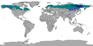
The subarctic climate is a climate characterised by long, cold winters, and short, warm to cool summers. It is found on large landmasses, often away from the moderating effects of an ocean, generally at latitudes from 50° to 70°N north, poleward of the humid continental climates. Subarctic or boreal climates are the source regions for the cold air that affects temperate latitudes to the south in winter. These climates represent Köppen climate classification Dfc, Dwc, Dsc, Dfd, Dwd and Dsd.
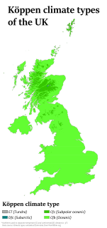
The United Kingdom straddles the higher mid-latitudes between 49° and 61°N on the western seaboard of Europe. Since the UK is always in or close to the path of the polar front jet stream, frequent changes in pressure and unsettled weather are typical. Many types of weather can be experienced in a single day. In general the climate of the UK is changeable, often cloudy especially in the more northerly areas of the country, with rain evenly distributed throughout the year.

The Köppen climate classification is one of the most widely used climate classification systems. It was first published by German-Russian climatologist Wladimir Köppen (1846–1940) in 1884, with several later modifications by Köppen, notably in 1918 and 1936. Later, the climatologist Rudolf Geiger (1894–1981) introduced some changes to the classification system, which is thus sometimes called the Köppen–Geiger climate classification system.

The climate of Chicago is classified as hot-summer humid continental. All four seasons are distinctly represented: Winters are cold and often see snow with below 0 Celsius temperatures and windchills, while summers are warm and humid with temperatures being hotter inland, spring and fall bring bouts of both cool and warm weather and fairly sunny skies. Annual precipitation in Chicago is moderate and relatively evenly distributed, the driest months being January and February and the wettest July and August. Chicago's weather is influenced during all four seasons by the nearby presence of Lake Michigan.
The climate of Salt Lake City, Utah features cold and snowy winters, hot and dry summers, and modest to light seasonal rainfall. Lying in the Salt Lake Valley, the city is surrounded by mountains and the Great Salt Lake. Under the Köppen climate classification, Salt Lake City has either a humid subtropical climate (Cfa) or a humid continental climate (Dfa) depending on which variant of the system is used, though it borders on a Mediterranean climate (Csa) or dry-summer continental climate (Dsa) as summers are quite dry.
Milwaukee has a humid continental climate, with four distinct seasons and wide variations in temperature and precipitation in short periods of time. The city's climate is also strongly influenced by nearby Lake Michigan, which creates two varying climates within the Milwaukee area. The Urban heat island effect also plays a role in the city's climate, insulating it from winter cold, but keeping it cooler in spring and summer.
Oklahoma City lies in a temperate humid subtropical climate, with frequent variations in weather daily and seasonally, except during the consistently hot and humid summer months. Consistent winds, usually from the south or south-southeast during the summer, help temper the hotter weather. Consistent northerly winds during the winter can intensify cold periods. Oklahoma City's climate transitions toward semi-arid further to the west, toward humid continental to the north, and toward humid subtropical to the east and southeast. The normal annual mean temperature is 61.4 °F (16.3 °C); the coolest year was 1895 with a mean of 57.9 °F (14.4 °C), while the warmest 2012 at 64.1 °F (17.8 °C). Precipitation averages 36.52 inches (928 mm) annually, falling on an average 84 days, with the warmer months receiving more; annual precipitation has historically ranged from 15.74 in (400 mm) in 1901 to 56.95 in (1,447 mm) in 2007. The sun shines about 69% of the time, with monthly percent possible sunshine ranging from 60% in December to 80% in July.
The climate of Delhi is an overlap between monsoon-influenced humid subtropical and semi-arid, with high variation between summer and winter temperatures and precipitation. Delhi's version of a humid subtropical climate is markedly different from many other humid subtropical cities such as São Paulo, New Orleans and Brisbane in that the city features dust storms and wildfire haze due to its semi-arid climate.
Columbus, Ohio has a humid continental climate, characterized by humid, hot summers and cold winters, with no dry season. The Dfa climate has average temperatures above 22 °C during the warmest months, with at least four months averaging above 10 °C, and below 0 °C during the coldest. The climate is transitional with the Cfa humid subtropical climate to the south, characterized by humid, hot summers and cool winters.
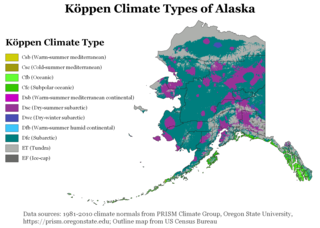
The climate of Alaska is determined by average temperatures and precipitation received statewide over many years. The extratropical storm track runs along the Aleutian Island chain, across the Alaska Peninsula, and along the coastal area of the Gulf of Alaska which exposes these parts of the state to a large majority of the storms crossing the North Pacific. The climate in Juneau and the southeast panhandle is a mid-latitude oceanic climate, in the southern sections and a subarctic oceanic climate in the northern parts. The climate in Southcentral Alaska is a subarctic climate due to its short, cool summers. The climate of the interior of Alaska is best described as extreme and is the best example of a true subarctic climate, as the highest and lowest recorded temperatures in Alaska have both occurred in the interior. The climate in the extreme north of Alaska is an Arctic climate with long, cold winters, and cool summers where snow is possible year-round.

The climate of Italy is the long-term weather pattern in the territory of the Italian Republic. The climate of Italy is influenced by the large body of water of the Mediterranean Seas that surrounds Italy on every side except the north. These seas constitute a reservoir of heat and humidity for Italy. Within the southern temperate zone, they determine a particular climate called Mediterranean climate with local differences due to the geomorphology of the territory, which tends to make its mitigating effects felt, especially in high pressure conditions.

The climate of the United States varies due to changes in latitude, and a range of geographic features, including mountains and deserts. Generally, on the mainland, the climate of the U.S. becomes warmer the further south one travels, and drier the further west, until one reaches the West Coast.
The climate of Gibraltar is Mediterranean/Subtropical with mild winters and warm summers. Gibraltar has two main prevailing winds, an easterly one known as the Levante coming from the Sahara in Africa which brings humid weather and warmer sea currents and the other as Poniente which is westerly and brings fresher air and colder sea. Its terrain consists of the 430-metre (1,411 ft) high Rock of Gibraltar and the narrow coastal lowland surrounding it. Rain occurs mainly in winter; the summers are generally dry.
Malta has a Mediterranean climate according to the Köppen climate classification (Csa), with very mild winters and warm to hot summers. Rain occurs mainly in winter, with summer being generally dry. According to the Troll-Paffen climate classification and the Siegmund/Frankenberg climate classification, Malta lies within the subtropical zone, being at 35ºN latitude.

The climate of Paraguay consists of a subtropical climate in the Paranaense region and a tropical climate in the Chaco. The Paranaense region has a humid climate, with abundant rainfall throughout the year and only moderate seasonal changes in temperature.

A humid subtropical climate is a humid temperate climate sub-type characterized by hot and humid summers, and cool to mild winters. These climates normally lie on the southeast side of all continents, generally between latitudes 25° and 40° and are located poleward from adjacent tropical climates. It is also known as warm temperate climate in some climate classifications.

The state of Alabama is classified as humid subtropical (Cfa) under the Köppen climate classification. The state's average annual temperature is 64 °F (18 °C). Temperatures tend to be warmer in the state's southern portion with its proximity to the Gulf of Mexico, while its northern portions, especially in the Appalachian Mountains in the northeast, tend to be slightly cooler. Alabama generally has very hot summers and mild winters with copious precipitation throughout the year. The state receives an average of 56 inches (1,400 mm) of rainfall each year and experiences a lengthy growing season of up to 300 days in its southern portion. Hailstorms occur occasionally during the spring and summer here, but they are seldom destructive. Heavy fogs are rare, and they are confined chiefly to the coast. Thunderstorms also occur year-around. They are most common in the summer, but they are most commonly severe during the spring and late autumn. That is when destructive winds and tornadoes occur frequently, especially in the northern and central parts of the state. Central and northern Alabama are squarely within Dixie Alley, the primary area in the U.S. outside the Southern Plains with relatively high tornado risk. Alabama is ranked second in the U.S for the deadliest tornadoes. Hurricanes are quite common in the state, especially in the southern part. Major hurricanes occasionally strike the coast, such as Hurricane Frederic in September 1979 and Hurricane Ivan in September 2004; both storms resulted in significant to devastating damage in the Mobile area.
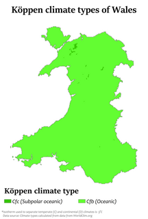
The climate of Wales refers to the weather conditions prevailing in Wales in general or over a long period.

Dubai has a hot desert climate. Dubai has two distinct seasons – winter and summer. Summer in Dubai begins around the last week of April and ends around the first week of October. This period is characterized by extremely hot weather, hot winds and high humidity. Due to the city's close proximity to the sea, the temperatures in Dubai are slightly milder in summer in comparison to other Gulf cities such as Kuwait City and Riyadh. However, this means the city has high humidity which can make the weather extremely unpleasant in summer. Rainfall is scarce during the summer months, but the windy conditions ensure there are frequent dust storms. Temperatures regularly climb above 38 °C (100 °F) during this period and fall to around 26 °C (79 °F) overnight. Winter in Dubai begins around the last week of October and lasts until the beginning of April. The winter season has the most pleasant weather, making it ideal for outdoor activities. Most of the precipitation takes place during this season. Strong thunderstorms are not uncommon to the city during this period, this is accompanied by strong north-westerly winds and lower temperatures. The Average daytime high during the winter season is around 22 °C (72 °F) with overnight lows of 12 °C (54 °F). Rainfall has been increasing over the past few decades in the city accumulating to more than 130 mm (5.12 in) per year.
The climate of Seoul features a humid continental climate with dry winter, called "Dwa" in the Köppen climate classification. Seoul is classed as having a temperate climate with four distinct seasons, but temperature differences between the hottest part of summer and the depths of winter are extreme. In summer the influence of the North Pacific high-pressure system brings hot, humid weather with temperatures soaring as high as 35 °C (95 °F) on occasion. In winter the city is topographically influenced by expanding Siberian High-pressure zones and prevailing west winds, temperatures dropping almost as low as -20 °C (-4 °F) in severe cold waves. The bitterly cold days tend to come in three-day cycles regulated by rising and falling pressure systems. The most pleasant seasons for most people in the city are spring and autumn, when azure skies and comfortable temperatures are typical. Most of Seoul's precipitation falls in the summer monsoon period between June and September, as a part of East Asian monsoon season.

