Quarrington Hill is a village in County Durham, in England. It is situated a short distance to the north of Kelloe.
Having been part of the extensive parish of Kelloe, it merged with the village of Cassop during the 19th century to form the parish of Cassop-cum-Quarrington, it is now in the parish of Coxhoe. As in most of County Durham, the chief trade here was coal mining and Cassop Colliery was where the miners worked.
The inhabitants of Quarrington Hill also shared the church of St. Pauls (built in 1868), with Cassop. The stones that were used in its construction were allegedly transported by William Smith, Innkeeper of the Half Moon Inn, Quarrington Hill, as he was the only villager to own such a cart to make this possible. It was closed during the 1980s and is now demolished. The churchyard is still used for burials.

Tanfield is a former mining village in County Durham, England, near Stanley, and the location of Tanfield Railway, the Causey Arch and Tanfield School.
The City of Durham was, from 1974 to 2009, a non-metropolitan district of County Durham in North East England, with the status of borough and city.

Cassop is a village in County Durham, in England. It has a population of about 500 and is located near the city of Durham. A former mining village, mining is no longer the main occupation of Cassop's inhabitants due to extensive mine closure over the last 30 years.

Croxdale is a village in the civil parish of Croxdale and Hett, situated about 3 miles (4.8 km) south of Durham City, in County Durham, England and on the A167 road, formerly part of the Great North Road. It is on the route of the East Coast Main Line and at one time had a station. The railway crosses over Croxdale Viaduct, built in 1872, just north of the village. The Weardale Way long distance footpath passes through the nearby Croxdale Hall estate.

Bowburn is a village in County Durham, England. It is situated about 3 miles (4.8 km) to the south-east of Durham, on the A177, between Coxhoe to the south-east, and High Shincliffe to the north-west.

Kelloe is a village and civil parish in County Durham, England. The population of the civil parish as taken at the 2011 Census was 1,502. It is situated to the south-east of Durham.

Urpeth is a village in County Durham, England. It is situated a short distance from Ouston and Beamish, near the border with Tyne and Wear. The parish population taken at the 2011 census was 3,630.
Old Quarrington is a hamlet in County Durham, in England. It is situated between Bowburn and Quarrington Hill. It is also known locally as Heugh Hall, which was the name of a local colliery.
Old Cassop is a hamlet in County Durham, in England. It is situated a few miles to the south-east of Durham. Old Cassop lies within the Cassop-cum-Quarrington civil parish.
Tursdale is a hamlet in County Durham, England. It is situated in rural landscape about two miles to the west of Coxhoe, two miles North of Cornforth and around five miles south of Durham. It is part of the civil parish of Cassop-cum-Quarrington. It is ideally located for speedy access to both Durham city, the A1M, and Teesside via Sedgefield. Despite its close proximity to many local amenities and towns, residents enjoy the peaceful lifestyle of living in a semi-rural location, with lovely views across the fields.

Pittington is a village and civil parish in County Durham, in England. It is situated a few miles north-east of Durham. The population as taken at the 2011 census was 2,534.

Sherburn Hill is a village in County Durham, in England. It is situated to the east of Sherburn.
Coxhoe is a village in County Durham, England. It is situated about 5 miles (8 km) south of Durham City centre. The civil parish also includes nearby Quarrington Hill. The electoral ward of Coxhoe stretches beyond the boundaries of the parish and has a total population of 7,027.
Great Lumley is a small-to-medium sized town in County Durham, England. It is situated south east of Chester-le-Street, near Lumley Castle. It has a population of 3,843, reducing to 3,684 at the 2011 census.
Waldridge is a village in County Durham, in England. The population at the 2001 Census was 215. Prior to the 2011 Census the parish boundaries changed and the population shown at this census was 4,215. It is situated to the south west of Chester-le-Street. It is known as either Waldridge Fell or Waldridge Village, the 'Fell' referring to the surrounding area of moorland. The village used to be known as Waldridge Colliery. The current village dates back to the 1890s, the original village having been located on the fell which overlooks the present location. Rainwater runs into the Cong Burn to the north and the South Burn to the south, both of which flow into the River Wear which is a few miles to the east.

Hutton Henry is a village in County Durham, in England near Peterlee, Castle Eden and Wingate. The population of the parish at the 2011 census was 1,565. It is situated to the west of Hartlepool, near the villages of Wingate and Station Town. At the top of hills in Hutton Henry you can get a fantastic view of the sea, Blackhall colliery, castle Eden, wingate, Peterlee and Shotton
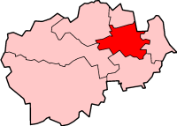
Cassop-cum-Quarrington is a civil parish in County Durham, England. According to the 2001 census it had a population of 4,735, increasing to 5,219 at the 2011 census.