Related Research Articles

Grand Canyon National Park, located in northwestern Arizona, is the 15th site in the United States to have been named as a national park. The park's central feature is the Grand Canyon, a gorge of the Colorado River, which is often considered one of the Wonders of the World. The park, which covers 1,217,262 acres of unincorporated area in Coconino and Mohave counties, received more than six million recreational visitors in 2017, which is the second highest count of all American national parks after Great Smoky Mountains National Park. The Grand Canyon was designated a World Heritage Site by UNESCO in 1979. The park celebrated its 100th anniversary on February 26, 2019.

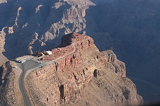
The Grand Canyon is a steep-sided canyon carved by the Colorado River in Arizona, United States. The Grand Canyon is 277 miles (446 km) long, up to 18 miles (29 km) wide and attains a depth of over a mile.

Coconino County is a county located in the north-central part of the U.S. state of Arizona. Its population was 134,421 at the 2010 census. The county seat is Flagstaff. The county takes its name from Cohonino, a name applied to the Havasupai people. It is the second-largest county by area in the contiguous United States, behind San Bernardino County, California. It has 18,661 sq mi (48,300 km2), or 16.4% of Arizona's total area, and is larger than each of the nine smallest states in the U.S.

Mohave County is in the northwestern corner of the U.S. state of Arizona. As of the 2010 census, its population was 200,186. The county seat is Kingman, and the largest city is Lake Havasu City. It is the fifth largest county in the United States.
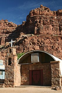
Supai is a census-designated place (CDP) in Coconino County, Arizona, United States, within the Grand Canyon.
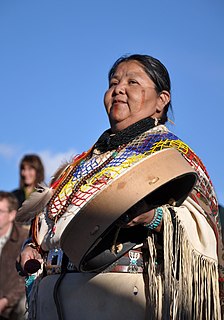
The Havasupai people are an American Indian tribe who have lived in the Grand Canyon for at least the past 800 years. Havasu means "blue-green water" and pai "people".
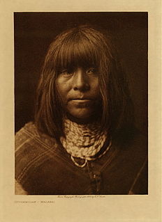
The Hualapai is a federally recognized Native American tribe in Arizona with about 2300 enrolled members. Approximately 1353 enrolled members reside on the Hualapai Reservation, which spans over three counties in Northern Arizona.

The known human history of the Grand Canyon area stretches back 10,500 years, when the first evidence of human presence in the area is found. Native Americans have inhabited the Grand Canyon and the area now covered by Grand Canyon National Park for at least the last 4,000 of those years. Ancestral Pueblo peoples, first as the Basketmaker culture and later as the more familiar Pueblo people, developed from the Desert Culture as they became less nomadic and more dependent on agriculture. A similar culture, the Cinchona, also lived in the canyon area. Drought in the late 13th century likely caused both groups to move on. Other people followed, including the Paiute, Cerbat, and the Navajo, only to be later forced onto reservations by the United States Government.

Grand Canyon National Park Airport is a state-owned public-use airport located in Tusayan, CDP in unincorporated Coconino County, Arizona, United States. It is near Grand Canyon National Park, 7 miles from the South Rim of the Grand Canyon. The airport is primarily used for scenic tours and charter flights, but there is scheduled commercial service.
The Agua Caliente Band of Cahuilla Indians of the Agua Caliente Indian Reservation is a federally recognized tribe of the Cahuilla, located in Riverside County, California. They inhabited the Coachella Valley desert and surrounding mountains between 5000 BCE and 500 CE. With the establishment of the reservations, the Cahuilla were officially divided into 10 sovereign nations, including the Agua Caliente Band.

The Grand Canyon Skywalk is a horseshoe-shaped cantilever bridge with a glass walkway at Eagle Point in Arizona near the Colorado River on the edge of a side canyon in the Grand Canyon West area of the main canyon. USGS topographic maps show the elevation at the Skywalk's location as 4,770 ft (1,450 m) and the elevation of the Colorado River in the base of the canyon as 1,160 ft (350 m), and they show that the height of the precisely vertical drop directly under the skywalk is between 500 ft (150 m) and 800 ft (240 m). In 2015 the attraction passed one million visitors.

Grand Canyon West Airport is a public airport 60 miles northwest of Peach Springs, in Mohave County, Arizona, United States. It is owned and operated by the Hualapai tribe and is on the Hualapai Indian Reservation.
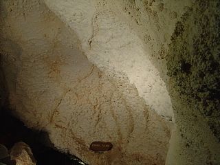
The Grand Canyon Caverns, located just a few miles east of Peach Springs, Arizona, lie 210 feet (64 m) below ground level. They are among the largest dry caverns in the United States. Dry caverns compose only 3% of caverns in the world. Because of the lack of water, stalagmites and stalactites are rare in the caverns.

Grand Canyon West is a census-designated place (CDP) in Mohave County, Arizona, United States, located on the Hualapai Reservation. The population was two at the 2010 census. Grand Canyon West is home to the tribe's Grand Canyon business operations, including the Grand Canyon West Airport and the Grand Canyon Skywalk.
The Bat Cave guano mine, located in the western Grand Canyon of Arizona at river mile 266, 800 feet (240 m) above Lake Mead, was an unusual, expensive and noteworthy mining operation. The natural cave was a bat habitat and contained an accumulation of guano.

Aubrey Cliffs are a series of cliff escarpments located in Coconino County, in northwestern Arizona.

The Grand Canyon mid-air collision occurred when Grand Canyon Airlines Flight 6, a de Havilland Canada DHC-6 Twin Otter that collided with a Bell 206 helicopter, Helitech Flight 2 over Grand Canyon National Park on June 18, 1986. All 25 passengers and crew on board the two aircraft were killed. It remains the deadliest accident involving a helicopter on United States soil, surpassing the crash of Los Angeles Airways Flight 841 in 1968, which killed 23 people.
Hualapai Valley is a valley in Mohave County, Arizona.

The Shivwits Plateau is a large plateau in northwest Arizona, and in the northwest of the Grand Canyon region. Just like the Kaibab Plateau in the east Grand Canyon forces the course of the Colorado River encircling it, the Shivwits Plateau is the major course changer of the Colorado in west Grand Canyon. The Colorado River goes due-south on the east perimeter of the plateau, goes west, then northwest to its outfall at Lake Mead. The southwest of the plateau borders the Colorado, but a lower elevation section is directly riverside; it is lower elevation hills and small canyons, called Sanup Plateau, and bordering the section of the Colorado called the Lower Granite Gorge.

The Grand Wash Cliffs extend south-southeast from the Grand Canyon-Parashant National Monument in northwest Arizona west of the Shivwits Plateau south through the Grand Cliffs Wilderness and into the Lake Mead Recreation Area. The Grand Wash Cliffs cross the Grand Canyon where the Colorado River enters Lake Mead. To the south of the Grand Canyon the Grand Wash Cliffs continue past the east side of Grapevine Mesa and then southeast above and east of the Hualapai Valley forming the southwest margin of the Music Mountains.
References
- ↑ U.S. Geological Survey Geographic Names Information System: Quartermaster Canyon
- 1 2 "Three die in Grand Canyon helicopter crash, four others injured". CNN. February 11, 2018. Retrieved 11 February 2018.
- ↑ Simmons, George Clarke; Gaskill, David L. (1969). Marble Gorge and Grand Canyon. Northland Press. p. 117.
named for a Hualapai Indian called "Quartermaster" who lived in the canyon from the early 1900s to about 1930.
- ↑ Fedarko, Kevin. "Are We Losing the Grand Canyon?". National Geographic. Retrieved 11 February 2018.