
The Queen Bess is a grade-II-listed (historic) public house in Scunthorpe, Lincolnshire, England. It opened in 1959 and is one of the few remaining examples of postwar pubs that have not been altered, closed down or demolished.
The Queen Bess is a grade-II-listed (historic) public house in Scunthorpe, Lincolnshire, England. It opened in 1959 and is one of the few remaining examples of postwar pubs that have not been altered, closed down or demolished.
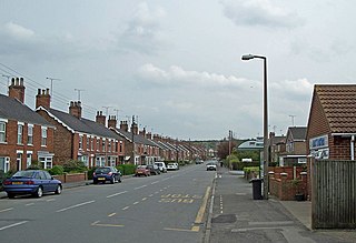
The pub is on Derwent Road, in the southeast of the town, close to the British Steel Corporation Scunthorpe Steelworks. [1]
Designed by local architects Wilburn and Son, the pub was built by the Samuel Smith Old Brewery—who remain the owners—and opened on 18 December 1959. It was named after a similarly titled blast furnace at the nearby Appleby-Frodingham steelworks, which had opened in 1950 and was at that point part of the biggest steelworks in Britain. [1] The sign outside the pub features a picture of Queen Elizabeth I on one side, and a picture of a blast furnace on the other. It quickly became a focal point of the local area. [2]
The premises has been largely unaltered since its construction. It was Grade-II-listed in 2018, as one of five postwar pubs—and the second in Scunthorpe—to be awarded this status. [3] [4] It features a brick exterior and a plain tile roof, which was designed to be compatible with new local housing developments. [3] [5]
The National Heritage List for England consider the pub to be one of the best examples of post–World War II 20th-century pub architecture, and notes that many pubs of a similar age have been closed or demolished. [1] Most of the interior fittings date from the original opening, including bar counters, fixed seating, furniture and doors. [5]

North Lincolnshire is a unitary authority area in Lincolnshire, England, with a population of 167,446 in the 2011 census. The borough includes the towns of Scunthorpe, Brigg, Haxey, Crowle, Epworth, Bottesford, Kirton in Lindsey and Barton-upon-Humber. North Lincolnshire is part of the Yorkshire and Humber region.
Scunthorpe is an industrial town in North Lincolnshire, in the ceremonial county of Lincolnshire, England. It is the county's third most populous settlement, after Lincoln and Grimsby.

Barton-upon-Humber or Barton is a town and civil parish in North Lincolnshire, England. The population at the 2011 census was 11,066. It is situated on the south bank of the Humber Estuary at the southern end of the Humber Bridge. It is 6 miles (10 km) south-west of Kingston upon Hull and 31 miles (50 km) north north-east of the county town of Lincoln. Other nearby towns include Scunthorpe to the south-west and Grimsby to the south-east.

The Appleby Frodingham Railway Preservation Society is based at Scunthorpe in North Lincolnshire. The society owns locomotives and rolling stock but not the railway it runs on. The name comes from the Appleby-Frodingham Steel Company, now known as British Steel Limited Scunthorpe after the companies buyout by Greybull Capital in 2016, and after going into compulsory liquidation in 2019, Jingye Group. The railway operates entirely within the Steelworks limits over tracks normally used for moving molten iron, steel and raw materials. Trains travel between 7 and 15 miles, all within the steelworks.

Tata Steel Europe Ltd. is a steelmaking company headquartered in London, England, with its main operations in the United Kingdom and the Netherlands. The company was created in 2007, when Tata Group took over the British-Dutch Corus Group. In 2021, the company was split into a British and a Dutch branch. Tata Steel Netherlands (TSN) and Tata Steel UK both of which fell directly under the Indian parent company Tata Steel and Tata Steel Europe ceased to exist.
Barnetby le Wold is a village and civil parish in North Lincolnshire, Lincolnshire, England, located between Brigg and Immingham. The village is also near Barton-upon-Humber. The population of the parish in the 2001 census was 1,593. This increased by 148 to 1,741 in the 2011 census.
Lincolnshire is one of the few counties within the UK that still uses the eleven-plus to decide who may attend grammar school, in common with Buckinghamshire and Kent.
The United Steel Companies was a steelmaking, engineering, coal mining and coal by-product group based in South Yorkshire and Lincolnshire, England.
Haxey is a town and civil parish on the Isle of Axholme in North Lincolnshire, England. It is directly south of Epworth, south-west of Scunthorpe, north-west of Gainsborough, east of Doncaster and north-west of Lincoln, with a population of 4,584 at the 2011 census. The town was regarded as the historic capital of the Isle of Axholme.

The Teesside Steelworks was a large steelworks that formed a continuous stretch along the south bank of the River Tees from the towns of Middlesbrough to Redcar in North Yorkshire, England. At its height there were 91 blast furnaces within a 10-mile radius of the area. By the end of the 1970s there was only one left on Teesside. Opened in 1979 and located near the mouth of the River Tees, the Redcar blast furnace was the second largest in Europe.
Fulstow is a marsh village and civil parish in the East Lindsey district of Lincolnshire, England. It is situated 6 miles (10 km) north of Louth and 8 miles (13 km) south of Grimsby.

Saxby All Saints is a village and civil parish in North Lincolnshire, England. The population of the civil parish at the 2011 census was 385. It is 6 miles (9.7 km) north of Brigg and 4 miles (6.4 km) south-west of Barton upon Humber.

Scunthorpe General Hospital is the main hospital for North Lincolnshire. It is situated on Church Lane in the west of Scunthorpe, off Kingsway, and north of the railway.

The Iron and Steel Industry in Scunthorpe was established in the mid 19th century, following the discovery and exploitation of middle Lias ironstone east of Scunthorpe, Lincolnshire, England.
Outwood Academy Brumby, is a mixed secondary school with academy status, in Scunthorpe (Brumby), North Lincolnshire, England.

The Darnall Works is a former steelworks in the Darnall area of Sheffield in England. The only remaining large complex of crucible furnaces, the works opened in the 1835 and were frequently extended and adapted until the late 20th century. Some of the structures at the works are listed buildings, at Grade II* and Grade II, and part of the site is a Scheduled Ancient Monument.
The Wheatsheaf is a grade II listed public house in Heatherside, Camberley, Surrey. It was designed by John and Sylvia Reid and opened in 1970. It has a distinctive ratchet-wheel design and connects to the local shopping precinct.
The Wilderspin National School is a former national school and Grade II listed building in Barton-upon-Humber, North Lincolnshire, and a museum focussing on the life and works of Samuel Wilderspin.
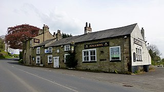
The Punch Bowl Inn was an 18th-century grade II-listed public house in Hurst Green, Ribble Valley, Lancashire, England. It consisted of a number of independent buildings, including what were originally two cottages and a barn, and a 19th-century extension. The pub was reputed to be haunted by the ghost of a highwayman. The pub closed in 2012 and afterwards stood empty. It was demolished in June 2021 without any planning permission to do so and an investigation followed, leading Ribble Valley Council to instruct the owners to rebuild it.
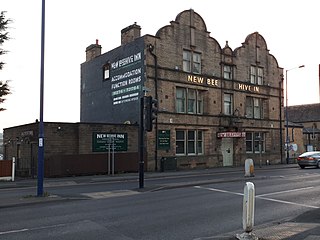
The New Beehive Inn is a former pub in Bradford, England. It was built by Bradford Corporation in 1901 to replace an existing public house of the same name that they had purchased in 1889 and demolished to widen a road. The corporation intended to run the pub itself but instead let it out and sold it in 1926. It has since been run by a number of brewery companies and individuals. The pub contained many features dating to its construction and a significant refurbishment in 1936 and was described by the Campaign for Real Ale as "one of the country's very best historic pub interiors".