
Reading is a town and borough in Berkshire, England. Most of its built-up area lies within the Borough of Reading, although some outer suburbs are parts of neighbouring local authority areas. Located in the Thames Valley at the confluence of the rivers Thames and Kennet, Reading is 40 miles (64 km) east of Swindon, 28 miles (45 km) south of Oxford, 40 miles (64 km) west of London and 16 miles (26 km) north of Basingstoke.

Henley-on-Thames is a town and civil parish on the River Thames, in the South Oxfordshire district, in Oxfordshire, England, 9 miles (14 km) northeast of Reading, 7 miles (11 km) west of Maidenhead, 23 miles (37 km) southeast of Oxford and 37 miles (60 km) west of London, near the tripoint of Oxfordshire, Berkshire and Buckinghamshire. The population at the 2021 Census was 12,186.

The A4 is a major road in England from Central London to Avonmouth via Heathrow Airport, Reading, Bath and Bristol. It is historically known as the Bath Road with newer sections including the Great West Road and Portway. The road was once the main route from London to Bath, Bristol and the west of England and formed, after the A40, the second main western artery from London.

Stamford is a town and civil parish in the South Kesteven district of Lincolnshire, England. The population at the 2011 census was 19,701 and estimated at 20,645 in 2019. The town has 17th- and 18th-century stone buildings, older timber-framed buildings and five medieval parish churches. It is a frequent film location. In 2013 it was rated a top place to live in a survey by The Sunday Times. Its name has been passed on to Stamford, Connecticut, founded in 1641.

State Library Victoria (SLV) is the state library of Victoria, Australia. Located in Melbourne, it was established in 1854 as the Melbourne Public Library, making it Australia's oldest public library and one of the first free libraries in the world. It is also Australia's busiest public library and, as of 2023, the third busiest library globally.
The North London Railway (NLR) company had lines connecting the northern suburbs of London with the East and West India Docks further east. The main east to west route is now part of London Overground's North London Line. Other NLR lines fell into disuse but were later revived as part of the Docklands Light Railway, and London Overground's East London Line. The company was originally called the East & West India Docks & Birmingham Junction Railway (E&WID&BJR) from its start in 1850, until 1853. In 1909, it entered into an agreement with the London and North Western Railway which introduced common management, and the NLR was taken over completely by the LNWR in 1922. The LNWR itself became part of the LMS from the start of 1923. The railways were nationalised in 1948 and most LMS lines, including the North London route, then came under the control of the London Midland Region of British Railways.

Twyford is a large village and civil parish in the Borough of Wokingham in Berkshire, England. It had a population of 6,618 in the 2011 Census. It is in the Thames Valley and on the A4 between Reading and Maidenhead, close to Henley-on-Thames and Wokingham.
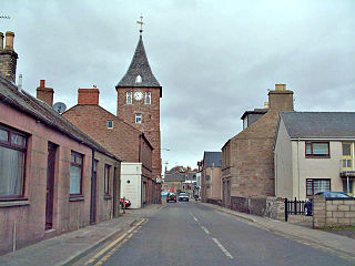
Coupar Angus is a town in Perth and Kinross, Scotland. It lies on the River Isla in the broad and fertile Valley of Strathmore, 4 miles south of Blairgowrie. The A94 road from Perth to Forfar runs through the town, and it had a station on the Midland Junction line until 1967.
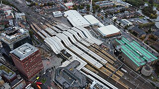
Reading railway station is a major transport hub in the town of Reading in Berkshire, England, it is 36 miles (58 km) west of London Paddington. It is sited on the northern edge of the town centre, near to the main retail and commercial areas and the River Thames. It is the busiest station in Berkshire, and the third busiest in South East England.

Windsor & Eton Central station is one of two terminal stations serving the town of Windsor, Berkshire, England. It is situated on Thames Street, almost immediately opposite Castle Hill, the main public entrance to Windsor Castle. The station is the terminus of a branch line from Slough operated by Great Western Railway.

Arthur Newbery Park is a park in Tilehurst, Reading, Berkshire. It is named after Arthur Newbery, who donated the land in 1932. It is one of Reading's oldest parks and was once part of Kentwood Common. Hollows in the park are remains of chalk and clay pits.

Greyfriars Church is an evangelical Anglican church, and former Franciscan friary, in the town centre of Reading in the English county of Berkshire. The church forms part of the Church of England's Diocese of Oxford.

Throgmorton Street is a road in the City of London that runs between Lothbury in the west and Old Broad Street in the east. Throgmorton Avenue runs from the north side of Throgmorton Street to London Wall.
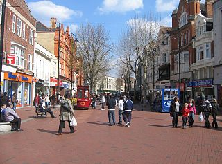
Broad Street is a main pedestrianised thoroughfare and the primary high street in the English town of Reading. The street is situated in the town centre, running for approximately 0.25 miles (0.40 km), from west to east. The western end of the road lies at the crossroads with Oxford Road, West Street and St Mary's Butts. The eastern end continues as King Street after the junction with Minster Street and Butter Market.

Friar Street is a thoroughfare in the English town of Reading. It runs parallel to Broad Street, connected by Union Street, Queen Victoria Street and Cross Street. At the western end is the Greyfriars Church and at the eastern end are the Town Hall and St Laurence's Church.

St Mary's Butts is a thoroughfare in the English town of Reading, Berkshire. On its west side is the Broad Street Mall. It is connected to the north with Broad Street, the pedestrianised primary high street of Reading. St Mary's Church and Butts are where the town of Reading originally grew from.
The statue of George Palmer stands in Palmer Park, in Reading, Berkshire. The statue, by George Blackall Simonds, was unveiled on 4 November 1891, though it was originally in Broad Street and only later moved to Palmer Park. The statue has been classed Grade II Listed monument since 14 December 1978.

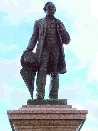
The statue of Queen Victoria stands at the eastern end of Friar Street outside the Town Hall of Reading, Berkshire, in southern England.

The following is a timeline of the history of Reading, the county town of Berkshire in England.
