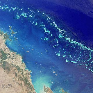
The Great Barrier Reef is the world's largest coral reef system composed of over 2,900 individual reefs and 900 islands stretching for over 2,300 kilometres (1,400 mi) over an area of approximately 344,400 square kilometres (133,000 sq mi). The reef is located in the Coral Sea, off the coast of Queensland, Australia, separated from the coast by a channel 100 miles wide in places and over 200 feet deep. The Great Barrier Reef can be seen from outer space and is the world's biggest single structure made by living organisms. This reef structure is composed of and built by billions of tiny organisms, known as coral polyps. It supports a wide diversity of life and was selected as a World Heritage Site in 1981. CNN labelled it one of the seven natural wonders of the world in 1997. Australian World Heritage places included it in its list in 2007. The Queensland National Trust named it a state icon of Queensland in 2006.
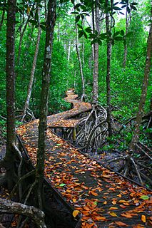
The Great Barrier Reef Marine Park protects a large part of Australia's Great Barrier Reef from damaging activities. It is a vast multiple-use Marine Park which supports a wide range of uses, including commercial marine tourism, fishing, ports and shipping, recreation, scientific research and Indigenous traditional use. Fishing and the removal of artefacts or wildlife is strictly regulated, and commercial shipping traffic must stick to certain specific defined shipping routes that avoid the most sensitive areas of the park. The Great Barrier Reef is the largest and best known coral reef ecosystem in the world. Its reefs, almost 3000 in total, represent about 10 per cent of all the coral reef areas in the world. It supports an amazing variety of biodiversity, providing a home to thousands of coral and other invertebrate species, bony fish, sharks, rays, marine mammals, marine turtles, sea snakes, as well as algae and other marine plants.

Water quality refers to the chemical, physical, and biological characteristics of water based on the standards of its usage. It is most frequently used by reference to a set of standards against which compliance, generally achieved through treatment of the water, can be assessed. The most common standards used to monitor and assess water quality convey the health of ecosystems, safety of human contact, extend of water pollution and condition of drinking water. Water quality has a significant impact on water supply and oftentimes determines supply options.

The Coral Sea is a marginal sea of the South Pacific off the northeast coast of Australia, and classified as an interim Australian bioregion. The Coral Sea extends 2,000 kilometres (1,200 mi) down the Australian northeast coast. The sea was the location for the Battle of the Coral Sea, a major confrontation during World War II between the navies of the Empire of Japan, and the United States and Australia.
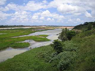
The Burdekin River is a river located in North and Far North Queensland, Australia. The river rises on the northern slopes of Boulder Mountain at Valley of Lagoons, part of the western slope of the Seaview Range, and flows into the Coral Sea at Upstart Bay over 200 kilometres (124 mi) to the southeast of the source, with a catchment area of approximately 130,000 square kilometres (50,000 sq mi). The Burdekin River is Australia's largest river by (peak) discharge volume.
The National Ocean Service (NOS), an office within the U.S. Department of Commerce National Oceanic and Atmospheric Administration (NOAA), is responsible for preserving and enhancing the nation's coastal resources and ecosystems along 95,000 miles (153,000 km) of shoreline bordering 3,500,000 square miles (9,100,000 km2) of coastal, Great Lakes, and ocean waters. Its mission is to "provide science-based solutions through collaborative partnerships to address evolving economic, environmental, and social pressures on our oceans and coasts." NOS works closely with many partner agencies to ensure that ocean and coastal areas are safe, healthy, and productive. National Ocean Service scientists, natural resource managers, and specialists ensure safe and efficient marine transportation, promote innovative solutions to protect coastal communities, and conserve marine and coastal places. NOS is a scientific and technical organization of 1,700 scientists, natural resource managers, and specialists in many different fields.

Soil salinity and dryland salinity are two problems degrading the environment of Australia. Salinity is a concern in most states, but especially in the south-west of Western Australia.

Environmental issue in Australia describes a number of environmental issues which affect the environment of Australia. There are a range of such issues, some of the relating to conservation in Australia while others, for example the deteriorating state of Murray-Darling Basin, have a direct and serious effect on human land use and the economy.
The Natural Heritage Trust (NHT), or National Heritage Trust Account was set up in 1997 by means of the Natural Heritage Trust of Australia Act 1997, with the main objective of conserving the "natural capital infrastructure" of Australia. Money from the NHT Account must be spent on the environment, sustainable agriculture and natural resources management (NRM). Since its establishment, a considerable number of community groups and organisations have received funding for environmental and natural resource management projects, delivered via a number of different initiatives since 1997. As of June 2020, the NHT account is funding a program known as Phase Two of the National Landcare Program. The original National Landcare Program was launched in 1992, but in 2014 merged with the Caring for our Country program.

The Normanby River, comprising the East Normanby River, the West Normanby River, the East Normanby River North Branch, the East Normanby River South Branch and the Granite Normanby River, is a river system located in Far North Queensland, Australia.
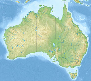
The Australian environment ranges from virtually pristine Antarctic territory and rainforests to degraded industrial areas of major cities. Forty distinct ecoregions have been identified across the Australian mainland and islands. Central Australia has a very dry climate. The interior has a number of deserts while most of the coastal areas are populated. Northern Australia experiences tropical cyclones while much of the country is prone to periodic drought. This dry and warm environment and exposure to cyclones, makes Australia particularly vulnerable to climate change -- with some areas already experiencing increases in wildfires and fragile ecosystems.

The Great Barrier Reef is the world's largest reef systems, stretching along the East coast of Australia from the northern tip down to the town of Bundaberg, is composed of roughly 2,900 individual reefs and 940 islands and cays that stretch for 2,300 kilometres (1,616 mi) and cover an area of approximately 344,400 square kilometres (133,000 sq mi). The reef is located in the Coral Sea, off the coast of Queensland in northeast Australia. A large part of the reef is protected by the Great Barrier Reef Marine Park.

Water efficiency is reducing water wastage by measuring the amount of water required for a particular purpose and the amount of water used or delivered. Water efficiency differs from water conservation in that it focuses on reducing waste, not restricting use. Solutions for water efficiency focus not only on reducing the amount of potable water used, but also on reducing the use of non-potable water where appropriate. It also emphasises the influence consumers can have in water efficiency by making small behavioural changes to reduce water wastage and by choosing more water efficient products.

Abbot Point Port is home to the North Queensland Export Terminal (NQXT), the most northerly deepwater coal port of Australia, situated approximately 25 kilometres (16 mi) north-west of the township of Bowen (Queensland). Established in 1984, it consists of a rail in-loading facility, coal handling and stockpile areas, and a single trestle jetty and conveyor connected to a berth and shiploader, located 2.75 km off-shore. Coal reaches the port via the GAP railway line from the Bowen Basin Coalfields.

Land clearing in Australia describes the removal of native vegetation and deforestation in Australia. Land clearing involves the removal of native vegetation and habitats, including the bulldozing of native bushlands, forests, savannah, woodlands and native grasslands and the draining of natural wetlands for replacement with agriculture, urban and other land uses.

Ove Hoegh-Guldberg, is a biologist and climate scientist specialising in coral reefs, in particular bleaching due to global warming and climate change. He has published over 500 journal articles and been cited over 50,000 times.
Environmental monitoring describes the processes and activities that need to take place to characterize and monitor the quality of the environment. Environmental monitoring is used in the preparation of environmental impact assessments, as well as in many circumstances in which human activities carry a risk of harmful effects on the natural environment. All monitoring strategies and programs have reasons and justifications which are often designed to establish the current status of an environment or to establish trends in environmental parameters. In all cases, the results of monitoring will be reviewed, analyzed statistically, and published. The design of a monitoring program must therefore have regard to the final use of the data before monitoring starts.

The United States Department of Energy's State Energy Program (SEP) provides grants to states and directs funding to state energy offices from technology programs in Office of Energy Efficiency and Renewable Energy. States use grants to address their energy priorities and program funding to adopt emerging renewable energy and energy efficiency technologies. Started in 2010, the program "is the only program administered by the U.S. Department of Energy (DOE) that provides cost-shared resources directly to the states for allocation by the governor-designated State Energy Office for use in energy efficiency and clean energy innovation, development, and demonstration activities.”
eWater is a non-profit organisation established by Australian Federal and State Governments. The role of eWater is to support integrated water resources management in Australia through development and implementation of the national hydrological modelling strategy (NHMS).
Bronwyn Harch is an Australian data scientist who brings digital technology and statistical sciences to sectors like agriculture, environment, health, manufacturing and energy. Harch has almost two decades of research leadership experience, primarily at CSIRO. She moved to the higher education sector in 2014 and most recently was executive director of the Institute for Future Environments (IFE) at Queensland University of Technology (QUT), Brisbane. In mid-2018, Harch joined The University of Queensland as the deputy vice chancellor (research) and vice president (research).


