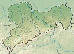
The Elbe Sandstone Mountains, also called the Elbe sandstone highlands is a mountain range straddling the border between the state of Saxony in southeastern Germany and the North Bohemian region of the Czech Republic, with about three-quarters of the area lying on the German side. The mountains are also referred to as Saxon Switzerland and Bohemian Switzerland in both German and Czech or simply combined as Saxon-Bohemian Switzerland. In both countries, the mountain range has been declared a national park. The name derives from the sandstone which was carved by erosion. The river Elbe breaks through the mountain range in a steep and narrow valley.

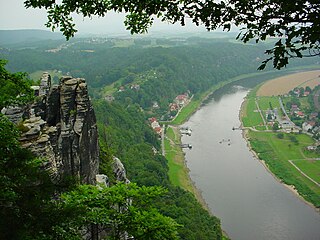
The Bastei is a rock formation towering 194 metres above the Elbe River in the Elbe Sandstone Mountains of Germany. Reaching a height of 305 metres above sea level, the jagged rocks of the Bastei were formed by water erosion over one million years ago. They are situated near Rathen, not far from Pirna southeast of the city of Dresden, and are the major landmark of the Saxon Switzerland National Park. They are also part of a climbing and hiking area that extends over the borders into the Bohemian Switzerland.

The Gohrisch is a table hill in the German region of Saxon Switzerland, left of the River Elbe in Saxony.

Hohnstein Castle is a medieval castle in the village of the same name, Hohnstein in Saxon Switzerland in the Free State of Sachsen in East Germany.

The Nonne is a roughly 18-metre-high, isolated, standing sandstone rock and climbing peak in Saxon Switzerland in Germany. The rock is located southeast of Rathen, east of the rock chain of Rauenstein.

The Barbarine is the best-known, free-standing rock formation in the German part of the Elbe Sandstone Mountains. It is a rock pinnacle, 42.7 metres (140 ft) high, and is the symbol of Saxon Switzerland. It was first climbed on 19 September 1905 by mountaineers.
Saxon Switzerland is one of the best-known climbing regions in Germany. The region is largely coterminous with the natural region of the same name, Saxon Switzerland, but extends well beyond the territory of the National Park within it. It includes the western part of the Elbe Sandstone Mountains and is the oldest non-Alpine climbing region in Germany. Its birth is usually reckoned to be the first ascent in modern times of the Falkenstein in 1864 by Bad Schandau gymnasts. Currently there are over 1,100 summits with more than 17,000 climbing routes in the Saxon Switzerland area.

The Cottaer Spitzberg is a 390.8 m high basalt dome on the western edge of Saxon Switzerland. Since 1979 the hill has been a protected area due to its geological and botanical features.
The Bergtest near Wehlen is a traditional sporting event that has taken place annually since 1980, usually on the last Saturday in March, in the East German hills of Saxon Switzerland.

The Teufelsturm is a prominent rock tower and climbing rock formed of Elbe Sandstone, about forty metres high in Saxon Switzerland in East Germany. It is located east of the River Elbe on the upper edge of the valley between Schmilka and Bad Schandau in the Schrammsteinen. The Teufelsturm is also referred to as the "Symbol of Saxon Climbing".

The Winterstein, also called the Hinteres Raubschloss, is an isolated, elongated rock massif in the hinterland of Saxon Switzerland in East Germany. On the summit there was once a medieval castle, also called Winterstein, of which remains such as rebates for timber beams, hewn-out steps and cisterns are still visible.

The Malá Pravčická Brána is a natural sandstone arch, that is about 2.3 m (7.5 ft) high and 3.3 m (11 ft) wide. It is located in Bohemian Switzerland near the red signposted main hiking route between Mezní Louka and Vysoká Lípa.

Grillenburg Sandstone and Niederschöna Sandstone belong to the Elbe Sandstones of central Europe. There used to be a number of sandstone quarries in the Tharandt Forest and its neighbourhood, not far from Höckendorf and Ruppendorf, near Grillenburg, Niederschöna and Hetzdorf in the state of Saxony. These Cretaceous sandstones emerged in the Cenomanian and Turonian ages. The aforementioned quarries have long since closed.

Neurathen Castle, which was first mentioned by this name in 1755, is located near the famous Bastei rocks near Rathen in Saxon Switzerland in the German Free State of Saxony. This was once the largest rock castles in the region, but today only the rooms carved out of the rock, passages, the cistern and rebates for the timber of the former wooden superstructure have survived. In the years 1982–1984 parts of the extensive castle were used to build the open-air museum.

The Großer Bärenstein is a 327 metres high table hill in the German region of Saxon Switzerland in the Free State of Saxony. Close by is the Kleiner Bärenstein which, together with the Großer Bärenstein, forms the massif known as the Bärensteine.
The Kleiner Bärenstein is a 338 metres high table hill in the German region of Saxon Switzerland in the Free State of Saxony. Close by is the Großer Bärenstein which, together with the Kleiner Bärenstein, forms the massif of the Bärensteine.

A pinnacle, tower, spire, needle or natural tower in geology is an individual column of rock, isolated from other rocks or groups of rocks, in the shape of a vertical shaft or spire.

The Schwedenlöcher is a gorge-like side valley of the Amselgrund near Rathen in Saxon Switzerland.