
Randolph County is a county on the central eastern border of the U.S. state of Alabama. As of the 2020 census, the population was 21,967. Its county seat is Wedowee. Its name is in honor of John Randolph, a member of the United States Senate from Virginia. Randolph County was a prohibition or dry county until 2012, when the citizens of Randolph County voted to repeal prohibition.

Wedowee is a town in Randolph County, Alabama, United States. At the 2010 census the population was 823, up from 818 in 2000. The small town is the county seat of Randolph County. It was initially incorporated in 1836, but its charter lapsed by the late 19th century. It was reincorporated in 1901.

Woodland is a town in Randolph County, Alabama, United States. At the 2010 census the population was 184, down from 192 in 2000. It incorporated in 1967.

The Tallapoosa River runs 265 miles (426 km) from the southern end of the Appalachian Mountains in Georgia, United States, southward and westward into the Appalachian foothills in Alabama. It is formed by the confluence of McClendon Creek and Mud Creek in Paulding County, Georgia. Lake Martin at Dadeville, Alabama is a large and popular water recreation area formed by a dam on the river. The Tallapoosa joins the Coosa River about 10 miles (16 km) northeast of Montgomery near Wetumpka to form the Alabama River.

The Colorado–Big Thompson Project is a federal water diversion project in Colorado designed to collect West Slope mountain water from the headwaters of the Colorado River and divert it to Colorado's Front Range and plains. In Colorado, approximately 80% of the state's precipitation falls on the West Slope, in the Rocky Mountains, while around 80% of the state's growing population lives along the eastern slope, between the cities of Fort Collins and Pueblo.

The Walter F. George Lake, named for Walter F. George (1878–1957), a United States senator from Georgia, is formed on the Chattahoochee River along the state line between Alabama and Georgia. It is also widely known by the name, Lake Eufaula – particularly in Alabama, where the state legislature passed a resolution on June 25, 1963, to give the lake that name. The 46,000 acres (190 km2) lake extends north about 85 miles (140 km) from the Walter F. George Lock and Dam and has approximately 640 miles (1,030 km) of shoreline. Popular activities along the lake include camping and trophy fishing.

Pickwick Landing Dam is a hydroelectric dam on the Tennessee River in Hardin County, in the U.S. state of Tennessee. The dam is one of nine dams on the river owned and operated by the Tennessee Valley Authority, which built the dam in the 1930s as part of a New Deal-era initiative to create a continuous navigation channel between the river's mouth and Knoxville, and bring economic development to the area. The dam impounds the 43,100-acre (17,400 ha) Pickwick Lake and its tailwaters are part of Kentucky Lake.

The New Waddell Dam is an embankment dam on the Agua Fria River in Maricopa County, Arizona, 35 miles (56 km) northwest of Phoenix. It serves as part of the Central Arizona Project (CAP) while also providing water for the Maricopa Water District. The dam creates Lake Pleasant with water from the Agua Fria and also the CAP aqueduct. In addition, it affords flood protection, hydroelectric power production and recreational opportunities. Construction on the dam began in 1985 and ended in 1994. Its reservoir submerged the Old Waddell Dam which was completed in 1927 after decades of planning.

Hirakud Dam is built across the Mahanadi River, about 15 kilometres (9 mi) from Sambalpur in the state of Odisha in India. It is the longest earthen dam in the world. Behind the dam extends a lake, Hirakud Reservoir, 55 km (34 mi) long. It is one of the first major multipurpose river valley projects started after India's independence. Hirakud Reservoir was declared a Ramsar site on 12 October 2021.
Neely Henry Lake is located on the Coosa River near Gadsden, Alabama. The lake was formed by the Neely Henry Dam, built in 1966 by Alabama Power Company for hydroelectric power and recreation.

Lost Creek Lake is a reservoir located on the Rogue River in Jackson County, Oregon, United States. The lake is impounded by William L. Jess Dam which was constructed by the U.S. Army Corps of Engineers in 1977 for flood control and fisheries enhancement. The lake and dam were the first completed elements of the multi-purpose Rogue River Basin Project, consisting of Lost Creek Lake, Applegate Lake and the Elk Creek project. The lake is located approximately 27 miles (43 km) northeast of Medford.
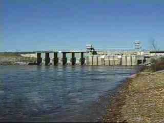
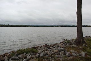
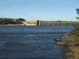
Lake Wedowee, or R. L. Harris Reservoir, is a reservoir, located in Randolph County, Alabama on the upper part of the Tallapoosa River 90 miles (140 km) from Atlanta, Georgia. The lake has an area of 9,870 acres (39.9 km2). This lake was built at one of the last hydro sites in Alabama.
Weiss Lake in northeastern Alabama is owned and operated by the Alabama Power Company. At full summer pool, Weiss Lake sits 564 feet (172 m) above sea level. The lake covers 30,200 acres (122 km2) from the Coosa River, Chattooga River (Alabama–Georgia) and Little River, offering over 447 miles (719 km) of shoreline and shallow flats, large coves, under-water drop offs and deep channels. Weiss Lake also has privately owned hotels, marinas, campground and bait and tackle stores. There are 11 bridges that cross Weiss Lake.
Martin Dam is a concrete arch gravity dam on the Tallapoosa River in Alabama in the United States, about 10 miles (16 km) southwest of Dadeville. Impounding the 40,000-acre (16,000 ha) Lake Martin, the dam was built in the 1920s to provide flood control, hydroelectric power generation and water supply. Originally known as the Cherokee Bluffs dam, the dam is named in honor of Thomas Wesley Martin, president of the Alabama Power Company during the dam's construction. The African American community of Kowaliga was submerged by Lake Martin.
The Pulangi IV Hydroelectric Power Plant, also known as the Pulangi Dam, is located on the Pulangi River near Maramag in Bukidnon province on the island of Mindanao in the Philippines. It uses two reservoirs, produced by damming the Pulangi River, to supply water to a run-of-the-river hydroelectric power plant; the power plant is capable of generating 255 megawatts (342,000 hp) of power. Construction began in 1982; the first two generators became operational in December 1985, with the last generator being commissioned in 1986.
Lay Dam is a hydroelectric power dam on the Coosa River in Chilton County and Coosa County, near Clanton, Alabama.

Jordan Lake is a lake in Elmore County, Alabama. The closest city is Wetumpka.
Walter Bouldin Dam is a dam in Elmore County, Alabama. The closest town is Wetumpka.

The Upper North Fork Feather River Project is a hydroelectric scheme in the Sierra Nevada of California, within Lassen and Plumas Counties. The project consists of three dams, five power plants, and multiple conduits and tunnels in the headwaters of the North Fork Feather River, a major tributary of the Feather—Sacramento River systems. The total installed capacity is 362.3 megawatts (MW), producing an annual average of 1,171.9 gigawatt hours (GWh). The project is also contracted for the delivery of irrigation water between March 31 and October 31 of each year. The project is owned and operated by Pacific Gas and Electric Company.
