The government of Zimbabwe is the main provider of air, rail and road services; historically, there has been little participation of private investors in transport infrastructure.
The National Railways of Zimbabwe (NRZ), formerly Rhodesia Railways, is a state-owned company in Zimbabwe that operates the country's national railway system.
Plumtree is a town in Zimbabwe. Alongside marula trees, wild plum trees grow abundantly in area. The town was once called Getjenge by baKalanga. Another name which is mainly used is Titji, meaning station and referring to the railway station which was operating in the area around 1897.
Brunapeg is a settlement in the Matabeleland South Province of Zimbabwe. It is one of the urban centres in Mangwe District, one of the seven administrative districts in the province.
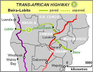
The Beira–Lobito Highway or TAH 9 is Trans-African Highway 9 in the transcontinental road network being developed by the United Nations Economic Commission for Africa (UNECA), the African Development Bank (ADB), and the African Union. The route has a length of 3,523 km (2,189 mi) crossing Angola, the most southerly part of the Democratic Republic of the Congo, Zambia, Zimbabwe, and central Mozambique.

The T1 or Lusaka–Livingstone Road is the main highway of the Southern Province of Zambia. It begins 55 kilometres south of the city of Lusaka and heads south-west to the principal tourist destination, Victoria Falls in Livingstone, Southern Africa, measuring approximately 430 kilometres (267 mi). The entire route is part of Trans-African Highway network number 4 or Cairo-Cape Town Highway between Cairo and Cape Town.

The A4 is a highway, also known as the R1 Highway, which runs between Beitbridge and Harare. From Beitbridge it passes through Rutenga, Ngundu, Masvingo, Mvuma, Chivhu before reaching Harare.
Railway station in Beitbridge include:

The A2 Highway is a primary road in Zimbabwe running from Harare to Nyamapanda at the border with Mozambique. The Mozambican side border post is called Cochemane. This is a busy entry point used by people travelling by road between South Africa, Malawi, Zimbabwe and Mozambique. It starts at intersection with Samora Machel Avenue; however Enterprise Road itself begins from the T-junction with Robert Mugabe Avenue, opposite the market in Eastlea, east of Simon Muzenda Street Road Port; a bus terminus for inter-regional buses.
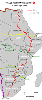
The Cairo–Cape Town Highway is Trans-African Highway 4 in the transcontinental road network being developed by the United Nations Economic Commission for Africa (UNECA), the African Development Bank (AfDB), and the African Union. The route has a length of 10,228 km (6,355 mi) and links Cairo in Egypt to Cape Town in South Africa.
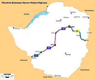
The Plumtree-Bulawayo-Harare-Mutare Highway is a cross country international standard highway in Zimbabwe. It connects Mutare with Plumtree via Harare and Bulawayo. It is formed by two routes, namely the R5 Road and the R2 Road.
The A5 Highway is a national road in Zimbabwe. It joins the cities of Harare and Bulawayo, and is hence known as the Harare-Bulawayo Highway or Harare-Bulawayo Road. It is one of the two routes that form the R2 Route, which connects Harare with the Plumtree Border with Botswana.
R3 Highway is a primary road in Zimbabwe from the capital city Harare to the Chirundu Border Post with Zambia. It is also known as the A1 Highway. It is part of both the Beira–Lobito Highway and the Cape to Cairo Road.
A9 Road (Zimbabwe) is a national highways running from Mutare to Mbalabala. The road begins in Mutare 18°59′01″S32°39′36″E and runs south-west through Nyanyadzi, Birchenough Bridge, Masvingo, Mashava, Zvishavane, Filabusi and ends at Mbalabala where it joins the (A6) Bulawayo-Beit Bridge Highway near the 61.5 km peg. It has a total of just less than 513 kilometres (319 mi), which is about a 6 hours 15 minute drive.

Chirundu–Beitbridge Road Corridor is a Trans-African Highway Network Zimbabwean link between South Africa and Zambia. It is part of the North–South Corridor Project and forms the entire Zimbabwean section of the Cape to Cairo Road.

R5 Highway is a 270.8 kilometres (168.3 mi) regional road corridor running from Harare to Mutare. It is also known as the A3 Highway. It is part of the Beira–Lobito Highway.
A7 Road is a national road in Zimbabwe that connects Bulawayo with the Plumtree Border Post with Botswana. It is popularly known as the Bulawayo-Plumtree Road. The A7 is part of Trans-Africa Highway 4. It is one of the two routes that form the R2 Route, which connects the Plumtree Border with Harare.
The R6 Highway is a primary road, a trunk road and regional road corridor link road in Zimbabwe.
The A8 Highway is a paved primary trunk road in Zimbabwe running from Bulawayo to Victoria Falls. It is managed by the Zimbabwe National Roads Administration (ZINARA).
R7 Highway is a primary, paved, regional road corridor in central Zimbabwe virtue of linking the regional corridors R1 Highways that runs from Harare to Beitbridge via Masvingo, and R2 Highway that runs from Harare to Plumtree via Bulawayo.
