
Cullinan is a small town in the Gauteng province of South Africa. It is located 30 km (19 mi) east of the city of Pretoria along the diamond route and is heavily reliant on tourism and the mine that dominates the skyline. The town is named after diamond magnate Sir Thomas Cullinan.
Koster is a small farming town situated on the watershed between the Orange and Limpopo Rivers in North West Province of South Africa.
The following lists events that happened during 1905 in South Africa.

The R25 is a provincial route in South Africa that connects Johannesburg with Groblersdal via Kempton Park, Bapsfontein and Bronkhorstspruit.

The R29 is a provincial route in South Africa that connects Johannesburg with Leandra and Kinross via Germiston, Boksburg, Benoni and Springs. For much of its route it is named Main Reef Road. The R29 used to end near the Golela border post with Eswatini, however the section from Evander to Ermelo is now part of the N17 and the section from Ermelo to the Golela border post just after Pongola is now part of the N2.
The R304 is a Regional Route in South Africa that connects Stellenbosch with Atlantis.
The R318 is a Regional Route in Western Cape, South Africa that connects the N1 between De Doorns and Touws River in the north-west with Montagu in the south-east via the Koo and Keisie Valleys.
The R407 is a Regional Route in South Africa that connects Willowmore with Prince Albert Road and the N1 via Klaarstroom and Prince Albert.

A Volkstaat, also called a Boerestaat, is a proposed White homeland for Afrikaners within the borders of South Africa, most commonly proposed as a fully independent Boer/Afrikaner nation. The proposed state would exclude Afrikaans-speaking Coloureds but accept South Africans of English ancestry and other White South Africans, if they accept Afrikaner culture and customs.
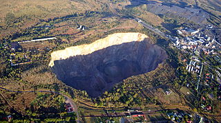
The Premier Mine is an underground diamond mine owned by Petra Diamonds in the town of Cullinan, 40 kilometres (25 mi) east of Pretoria, Gauteng Province, South Africa. Established in 1902, it was renamed the Cullinan Diamond Mine in November 2003 in celebration of its centenary. The mine is a carrot-shaped volcanic pipe and has a surface area of 32 hectares. The mine rose to prominence in 1905, when the Cullinan Diamond – the largest rough diamond of gem quality ever found – was discovered there.

The Pretoria Armour Regiment is a reserve armoured regiment of the South African Army.
Rayton is a town in North-Eastern Gauteng which started out as a tin shack mining town on the farm Elandshoek. During its boom days the town served the needs of thousands of diggers and prospectors working for the Schiller, Montrose and Dunmore mining companies. A mini diamond rush sparked by Sir Thomas Cullinan's discovery of a kimberlite diamond pipe nearby is what caused the town to boom.
The R513 is a Regional Route in South Africa that connects Hartbeespoort with Bronkhorstspruit via Akasia, Pretoria North and Cullinan.
The R564 is a Regional Route in the City of Johannesburg Metropolitan Municipality in Gauteng, South Africa. It connects Roodepoort with Buccleuch via Northriding and Fourways.
In South Africa, as elsewhere in the world, the railways played a huge part in development and growth on nearly all terrains in the country. Conversely, events in South Africa and its neighbours over the years had a huge influence on the development of railways.
The M45 is a long metropolitan route in Greater Johannesburg, South Africa. It connects Kempton Park with Dunnottar via Benoni, Brakpan, KwaThema and Tsakane. The entire route is in the City of Ekurhuleni Metropolitan Municipality.
The M56 is a short metropolitan route in Greater Johannesburg, South Africa. It connects Boksburg with the northern part of Springs via Brakpan.
The Willem Prinsloo Agricultural Museum is an agricultural museum part of the Ditsong Museums of South Africa. The museum exhibits agricultural technology from the Stone Age through to the Second World War. It is located on the R104 in Rayton, near Cullinan, Gauteng, South Africa.
