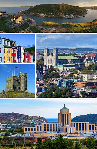
St. John's is the capital and largest city of the Canadian province of Newfoundland and Labrador. It is located on the eastern tip of the Avalon Peninsula on the island of Newfoundland. The city spans 446.04 km2 (172.22 sq mi) and is the easternmost city in North America.
Grand Falls-Windsor is a town located in the central region of the island of Newfoundland in the province of Newfoundland and Labrador, Canada, with a population of 13,853 at the 2021 census. The town is the largest in the central region, the sixth largest in the province, and is home to the annual Exploits Valley Salmon Festival. Grand Falls-Windsor was incorporated in 1991, when the two former towns of Grand Falls and Windsor amalgamated.
Upper Island Cove, Newfoundland and Labrador is a town in Newfoundland and Labrador, Canada. It is located in Census Division No. 1 and was incorporated on October 19, 1965. It is located northeast of Bay Roberts. As of 2021, the population is 1,401.

Stephenville is a town in Newfoundland and Labrador, Canada, on the west coast of the island of Newfoundland.

Marystown is a town in the province of Newfoundland and Labrador, Canada, with a population of around 5,000. Situated 306 km from the province's capital, St. John's, it is on the Burin Peninsula. Until the early 1990s, its economy was largely based on shipbuilding, and it is due in part to this that the town experienced a population increase of 295% in just over a decade. The town was also dependent on the fish plant for employment.

Carbonear is a town on the Avalon Peninsula in Newfoundland and Labrador, Canada. It overlooks the west side of Conception Bay and had a history long tied to fishing and shipbuilding. Since the late 20th century, its economy has changed to emphasize education, health care, retail, and industry. As of 2021, there were 4,696 people in the community.

Grates Cove is a local service district and designated place in the Canadian province of Newfoundland and Labrador. It is the most northerly community on the Avalon Peninsula, located on the tip of the Bay de Verde Peninsula on the island of Newfoundland. Called "the Grates" by John Guy as early as 1612, the origin of the name is unknown.

Quidi Vidi is a neighbourhood in St. John's, Newfoundland and Labrador. Its pronunciations vary, even amongst longtime residents, but "Kiddy Vidi" is the most common. One theory behind the name is that it was named after a beloved cat named Vidi. The village is adjacent to Quidi Vidi Lake. Quidi Vidi's harbour is known as "The Gut". Located in Quidi Vidi is the Quidi Vidi Battery Provincial Historic Site. The village is home to several small businesses.
Goulds is a designated place in the Canadian province of Newfoundland and Labrador. It is a rural neighbourhood within the City of St. John's southeast of the city centre.
Wedgewood Park is a neighbourhood in St. John's, Newfoundland and Labrador, located north of the city centre.

Stephenville Crossing is a town in the Canadian province of Newfoundland and Labrador. It is on the island of Newfoundland at the easternmost limit of Bay St. George.

Georgestown is a Neighbourhood Improvement Area in St. John's, Newfoundland and Labrador a short distance north from downtown of St. John's. This was established in the 1970s as part of an effort by Federal and local government to improve inner cities. Originally what was known as Georgestown village was much smaller and only "extended from Donnelly's Lane to what is now Belvedere Street". The neighbourhood improvement area includes, in addition to the original Georgestown, the former Monkstown and Tubridtown, along with adjoining land, including Circular Road, and Belvedere Street as well as some other parts of the former Belvedere Estate. It is bordered by Military Road, Monkstown Road, Empire Avenue, a small part of Carpasian Road, the east side of Bonaventure Avenue, and Holy Heart and Brother Rice Schools to the west. It was settled, around 1819, as the city's first suburb. The name is an evolution of "George (Winter)'s Town", as it was known in the 19th century.

The LSPU Hall is a large wooden structure in St. John's, Newfoundland and Labrador. Located on 3 Victoria Street, it is currently the home of the Resource Centre for the Arts (RCA). The name comes from a previous owner, the Longshoremen's Protective Union. The Hall is a registered heritage building.
The neighbourhood of Pleasantville in St. John's, Newfoundland and Labrador is located in the east end of the city, directly north of the downtown. The neighbourhood extends from the north side of Quidi Vidi Lake northward to Newfoundland Drive, and is largely made up of apartment blocks.
Virginia Park is a neighbourhood in the northeast end of St. John's, Newfoundland and Labrador.
Kenmount Road is a major road in St. John's, Newfoundland and Labrador. It begins at the intersection of Freshwater Road and Thorburn Road, just east of the Columbus Drive overpass. Originally passing through rural farmland, Kenmount Road is now a significant commercial area, with the Avalon Mall at its eastern end, followed by a series of car dealerships, restaurants, hotels, and other businesses. At its western end, Kenmount Road intersects Topsail Road and the Trans-Canada Highway, and has been extended into the Town of Paradise, where it runs into another road, McNamara Drive.
The neighbourhood of Churchill Park in St. John's, Newfoundland and Labrador is located in the city's centre. The neighbourhood is bordered by Freshwater Road to the west, Empire Avenue to the south, Kenna's Hill, Kingsbridge and Torbay Roads to the east and Elizabeth Avenue to the north. Its main east-west thoroughfares are Elizabeth Avenue and Empire Avenue, and its main north-south thoroughfares are Portugal Cove Road and Allandale Road. The neighbourhood borders the campus of Memorial University of Newfoundland to the north, and as a result, it is home to a sizable student population. The area is made up of single-family homes, mostly built in the 1950s and 1960s.

Downtown St. John's is the historic core, and central business district of St. John's, Newfoundland and Labrador, Canada. Located north of St. John's harbour, it is the business, entertainment, and tourism centre with office buildings, hotels, restaurants, and other services.
The neighbourhood of Buckmaster's Circle is located in central area of St. John's, Newfoundland and Labrador, Canada.

Division No. 1, Subdivision G is an unorganized subdivision on the Avalon Peninsula in Newfoundland and Labrador, Canada. It is in Division 1 and contains the unincorporated communities of Baccalieu Island, Besom Cove, Bradley's Cove, Burnt Point, Caplin Cove, Daniel's Cove, Grates Cove, Gull Island, Job's Cove, Kingston, Long Beach, Lower Island Cove, Low Point, Northern Bay, Ochre Pit Cove, Red Head Cove, Riverhead, Smooth Cove and Western Bay.

