
The Triglav Lakes Valley is a rocky hanging valley in the Julian Alps in Slovenia, below the sheer sides of Mount Tičarica and Mount Zelnarica southwest of Triglav. The valley is also called the Seven Lakes Valley, although there are ten and not seven lakes in the valley. It is above the tree line and is geologically alpine karst; therefore it has also been termed the Sea of Stone Valley.

Grintovec is the highest mountain of the Kamnik–Savinja Alps, with an elevation of 2,558 metres (8,392 ft). It is a popular location for hiking, climbing and skiing. The first recorded ascent was in 1759 by the botanist Giovanni Antonio Scopoli.
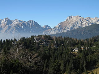
The Big Pasture Plateau is a karstified mountain plateau in the Kamnik–Savinja Alps northeast of Kamnik, Slovenia. It measures 5.8 square kilometres and has an average elevation of 1,500 metres above sea level. Its highest point is Mount Gradišče, at 1,666 m (5,466 ft). There are numerous herders' dwellings that comprise several settlement areas: Velika Planina 'Big Pasture', Mala Planina 'Little Pasture', Gojška Planina 'Gozd Pasture', Tiha Dolina 'Quiet Valley', and others. The Big Pasture Plateau is a tourist destination both in winter as a ski resort and in summer as a place for relaxation.

Kočna at 2,540 metres (8,330 ft) high, is the second-highest mountain in the Kamnik–Savinja Alps and the westernmost peak of the Grintovec Range. Its prominent and easily recognized peak is visible from far around. The mountain has two peaks: the higher Jezersko Kočna and the nearby lower Kokra Kočna.

Kanjavec is a 2,569-metre (8,428 ft) mountain in the center of Triglav National Park. It lies between the Dolič Pass at 2,164 m, the Hribarice Pass at 2,306 m and the Prehodavci Pass at 2071 m. Kanjavec is also a popular ski touring destination. From the summit, there is a panoramic view of the surrounding mountains. It is relatively easy to ascend, with a few exposed areas.

The Kalce Ridge is a 2,224-metre-high (7,297 ft) mountain of the Kamnik–Savinja Alps in northern Slovenia. It is the highest peak of the Krvavec Group.
The Slovenian Mountain Hiking Trail, sometimes also called Transverzala, is a route from Maribor to Ankaran. It covers most of the Slovenian mountain areas including Pohorje, the Julian Alps, the Kamnik-Savinja Alps, the Karawanks, and the southwestern part of Slovenia. It is the oldest hiking track in Europe.

The Storžič Lodge is a mountain hostel in the upper part of the Lomščica Valley, near the Jesenje Pasture in northwestern Slovenia. The first lodge was built in 1938 and was called the Verbič Lodge ; it caught fire one year later. It burned in 1941 when German forces attacked the Storžič Battalion. The current brown shingled hut was built in 1951.

The Ribnica Lodge is the highest mountain lodge in the Pohorje Mountains. It lies on a small plateau under Mali črni vrh in the central area of the Pohorje. The hut is open all year round. It is accessible by car from Ribnica na Pohorju. There is also a small ski resort with three surface lifts.

The Smrekovec Lodge is a mountain hostel on the southern slope of the Smrekovec Mountains in the Kamnik–Savinja Alps. The first lodge was built in 1933, but it was burned down during World War II. A new lodge was built in 1951, and expanded in 1976–77.

The Zois Lodge at Kokra Saddle is a mountain hostel that stands on Kokra Saddle, part of the Kamnik–Savinja Alps. It is named after the brothers Karl Zois (1756–1799), and Sigmund Zois (1747–1819).

The Loka Lodge at Raduha is a mountain hostel that stands on the Loka Plateau in northern Slovenia. It is open from the start of June to the end of August.

The Kocbek Lodge at Korošica is a mountain lodge standing on the Korošica Pasture on the Dleskovec Plateau, below the southern slope of Mount Ojstrica. It is named after Fran Kocbek, an early promoter of mountain hiking in the Kamnik–Savinja Alps. The first lodge, which was built in 1876, burnt in 1881. A year later a new one was built. During World War II, it was captured by the Germans. It was expanded and modified from 1969 to 1973. The lodge was destroyed by a fire on October 20, 2017.
The Frischauf Lodge at Okrešelj is a mountain lodge that stands above the Logar Valley in northern Slovenia. It is surrounded by the following peaks: Cold Mountain, Styria Mount Rinka, Carinthia Mount Rinka, and Mount Turska. Nearby is 80-meter (260 ft) Rinka Falls. The lodge is named after Johannes Frischauf, and the first lodge was built in 1876 by an Austro-German hiking club. In 1907 it was destroyed by an avalanche and rebuilt again in 1908. In 1991 it was expanded and modernized.

The Planika Lodge at Triglav is a mountain hut, which lies on the Ledine plains on the southern side of Mount Triglav. The First hut, also called the Triglav Tempe, was built on 18 September 1871. In 1877, the Austro-German hiking club built a hut called the Maria Theresa Hut. On 13 August 1911, there was another building added called the Maria Theresa Lodge. After World War I, the Slovenian Hiking club took over the hut and renamed it the Aleksander Lodge. The hut was transformed to a border garrison Karaula for a while. In 1945, the Gorje Hiking Club renamed it to Planika Lodge at Triglav. In 1987, Karaula was demolished and a bigger annex was built at its place on 19 August 1992.

The Czech Lodge at Spodnje Ravni is a mountain hostel that stands on the Spodnje Ravni Cirque above the Ravni Combe below the northern part of Mount Grintovec and the Long Ridge. It has been named after the Czechs from Prague who built it in 1900. In the 1970s, it was renovated, but the Czech architectural style remained. It is managed by the Jezersko Mountaineering Club. Its groundskeeper was for 40 years Andrej Karničar, then for 10 ten years Tone Karničar, and since July 2015 Karmen Karničar.

Begunjščica is a ridge mountain in the Karawanks. It rises from the western Smokuč mountain pasture to St. Anne on its eastern side. The mountain has three main peaks, the highest being Big Peak. The western Middle Peak lies a little lower, and the lowest is Begunje Mount Vrtača. Its southern slopes rise over the Draga Valley. The ascent of the mountain is relatively easy and possible throughout the year. In the winter and early spring conditions are favourable for ski touring.
Mount St. Ursula or Plešivec is the easternmost peak of the Karawanks. It lies between the towns of Slovenj Gradec and Črna na Koroškem. There are three villages on the slopes of the mountain: Uršlja Gora, Podgora, and Zgornji Razbor. The mountain offers a panoramic view towards all of Carinthia, the Kozjak Mountains, and the Kamnik–Savinja Alps. Below the peak of Mount St. Ursula stands the Gothic St. Ursula's Church, a TV mast tower, a mountain lodge, 1,670 m or 5,480 ft), and a monument to the soldiers fallen in World War I.. The name Plešivec derives from its grey limestone peak.

The Prešeren Lodge at Stol is a mountain hut on the southern side of Mt. Stol in the Karawanks, just below the peak of Little Stol. It is named after the Slovenian poet France Prešeren. The first hut was built in 1909. During World War II, it was burnt down; it was rebuilt in 1966.

The Triglav Lodge at Kredarica is the highest mountain hut in Slovenia and the highest meteorological station in the country. It stands on a small plateau just under the peak of Kredarica, an elevation in the ridge between Mt. Rjavina and Mt. Triglav. The Valentin Stanič Lodge stands to the northeast below Begunje Peak, and the Planika Lodge at Triglav stands to the south. In the vicinity there is also a chapel dedicated to Our Lady of the Snows, and a few metres away there is a small cave named Ivačič Cave.


