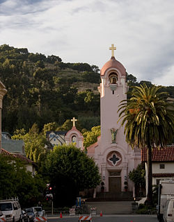
Mission San Rafael Arcángel was founded in 1817 as a medical asistencia ("sub-mission") of Mission San Francisco de Asís. It was a hospital to treat sick Native Americans, making it Alta California's first sanitarium. The weather was much better than in San Francisco, which helped the ill get better. It was not intended to be a stand-alone mission, but nevertheless grew and prospered and was granted full mission status on October 19, 1822.

San Rafael is an affluent city and the county seat of Marin County, California, United States. The city is located in the North Bay region of the San Francisco Bay Area. As of the 2010 census the city's population is 57,713.

The Coast Miwok are an indigenous people that was the second largest group of Miwok people. The Coast Miwok inhabited the general area of modern Marin County and southern Sonoma County in Northern California, from the Golden Gate north to Duncans Point and eastward to Sonoma Creek. The Coast Miwok included the Bodega Bay Miwok, from authenticated Miwok villages around Bodega Bay, and the Marin Miwok.
San Rafael is a common place-name in areas where that tongue is or was spoken:

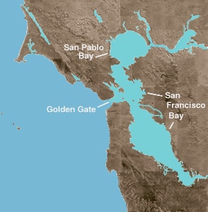
San Pablo Bay is a tidal estuary that forms the northern extension of San Francisco Bay in the East Bay and North Bay regions of the San Francisco Bay Area in northern California.

The Richmond–San Rafael Bridge is the northernmost of the east–west crossings of the San Francisco Bay in California, USA. Officially named after California State Senator John F. McCarthy, it bridges Interstate 580 from Richmond on the east to San Rafael on the west. It opened in 1956, replacing ferry service by the Richmond–San Rafael Ferry Company.

The North Bay is a subregion of the San Francisco Bay Area, in California, United States. The largest city is Santa Rosa, which is the fifth-largest city in the Bay Area. It is the location of the Napa and Sonoma wine regions, and is the least populous and least urbanized part of the Bay Area. It consists of Marin, Napa, Solano and Sonoma counties.

The Crescenta Valley is a small inland valley in Los Angeles County, California, lying between the San Gabriel Mountains on the northeast and the Verdugo Mountains and San Rafael Hills on the southwest. It opens into the San Fernando Valley at the northwest and the San Gabriel Valley at the southeast. It is nearly bisected by the Verdugo Wash, a smaller valley separating the Verdugo Mountains from the San Rafael Hills. Most of the valley lies at an elevation of over 1,500 feet.

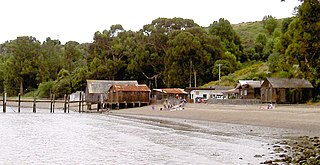
China Camp State Park is a state park of California, United States, surrounding a historic Chinese American shrimp-fishing village and a salt marsh. The park is located in San Rafael, California, on the shore of San Pablo Bay. It is known for its hiking and mountain biking trails, scenic views, and open spaces. The 1,514-acre (613 ha) park was established in 1976. A 75-acre (30 ha) district, including the shrimping village and a prehistoric shell midden, were added to the National Register of Historic Places in 1979 for having state-level significance in archaeology, architecture, commerce, settlement, and social history.

San Quentin is a small unincorporated community in Marin County, California, United States. It is located west of Point San Quentin, at an elevation of 30 feet.

Francisco Rafael Arellano Félix was a Mexican drug lord and former leader of the Tijuana Cartel, a drug trafficking organization. He was the oldest of seven brothers and headed the criminal organization early in the 1990s alongside them. Through his brother Benjamín, Francisco Rafael joined the Tijuana Cartel in 1989 following the arrest of Miguel Ángel Félix Gallardo, one of the most prominent drug czars in Mexico during the 1980s. When the Arellano Félix took control of the organization in the early 1990s, tensions with the rival Sinaloa Cartel prompted violent attacks and slayings from both fronts.

San Rafael Creek is a watercourse in Marin County, California, United States that discharges to San Rafael Bay, a small embayment of the San Francisco Bay. The mouth of San Rafael Creek is a channelized estuary through an industrial area. San Rafael Creek has a designation under Federal Law Section 303(d) as impaired by diazinon, the principal pollutant causing impairment designations for streams discharging to San Pablo Bay, which is the northern arm of San Francisco Bay. In September 2007, the organization Save The Bay designated San Rafael Creek as one of the top ten "worst trash hot spot" waterways flowing into the San Francisco Bay. The channel portion of San Rafael Creek below the Grand Street Bridge is dredged on a regular maintenance schedule to keep the shallow draft channel navigable. Dredge spoils are disposed of at a site near Alcatraz Island.
San Rafael City Schools is a school district headquartered in San Rafael, California, United States.
Rancho San Rafael was a 36,403-acre (147.32 km2) Spanish land grant in the San Rafael Hills, bordering the Los Angeles River and the Arroyo Seco in present-day Los Angeles County, southern California, given in 1784 to Jose Maria Verdugo.

San Rafael Bay is an embayment of San Pablo Bay, located in Marin County and the northern San Francisco Bay Area, California.

The Marin Independent Journal is the main newspaper of Marin County, California. The paper is owned by California Newspapers Partnership which is in turn mostly owned by MediaNews Group.
Hahamongna and Hahamog-na are historic Tongva-Gabrieleño Native American settlements in the Verdugo Mountains of Southern California, named after the local Tongva band's name Hahamog'na, in present-day Pasadena and Glendale in Los Angeles County, California.

Sedgwick Reserve is a 5,896-acre (2,386 ha) nature reserve in California. It is located in the San Rafael Mountains, 35 miles north of Santa Barbara near the town of Santa Ynez in Santa Barbara County, California.

The San Rafael Pacifics are a professional baseball team based in San Rafael, California, United States and are a charter franchise of the six-team Pacific Association of Professional Baseball Clubs, an independent professional baseball circuit not affiliated with Major League Baseball.


