
The United States Department of Transportation is one of the executive departments of the U.S. federal government. It is headed by the secretary of transportation, who reports directly to the president of the United States and is a member of the president's Cabinet.
Railbanking is the practice of preserving rail corridors for possible future use. Railbanking leaves the railroad, railbed, bridges or bridge corridor, and other infrastructure intact. This relieves the railroad's operator from the responsibility of maintenance, and from taxation. Existing rails may or may not be maintained intact on the railbed, depending on their condition or any planned interim use of the railbed. Often the rail corridor is put in custody of a state transportation agency, which then seeks a new operator for possible rehabilitation or reactivation. This helps ensure the possibility of future restored rail service when new economic conditions may warrant resuming operation.
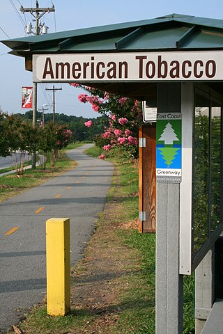
The American Tobacco Trail (ATT) is a 22.6-mile (36.4 km) long Rails-to-Trails project located in the Research Triangle region of North Carolina, running along an abandoned railroad bed originally built for the American Tobacco Company in the 1970s. The route crosses through portions of Durham County, Chatham County, and Wake County. The ATT is part of the East Coast Greenway and is open to pedestrians, cyclists, equestrians and other non-motorized users.

The Alaska Railroad is a Class II railroad that operates freight and passenger trains in the state of Alaska. The railroad's mainline runs between Seward on the southern coast and Fairbanks, near the center of the state. It passes through Anchorage and Denali National Park, to which 17% of visitors travel by train.

A rail trail is a shared-use path on a railway right of way. Rail trails are typically constructed after a railway has been abandoned and the track has been removed but may also share the right of way with active railways, light rail, or streetcars, or with disused track. As shared-use paths, rail trails are primarily for non-motorized traffic including pedestrians, bicycles, horseback riders, skaters, and cross-country skiers, although snowmobiles and ATVs may be allowed. The characteristics of abandoned railways—gentle grades, well-engineered rights of way and structures, and passage through historical areas—lend themselves to rail trails and account for their popularity. Many rail trails are long-distance trails, while some shorter rail trails are known as greenways or linear parks.
Rails-to-Trails Conservancy (RTC) is an American nonprofit organization based in Washington, D.C., that works with communities to preserve unused rail corridors by transforming them into rail trails within the United States. RTC's purpose is to create a nationwide network of trails from former rail lines and connecting corridors.

The Southeast Corridor (SEC) is a proposed passenger rail transportation project in the Mid-Atlantic and Southeastern United States to extend high-speed passenger rail services from the current southern terminus of the Northeast Corridor in Washington, D.C. Routes would extend south via Richmond and Petersburg, Virginia, with a spur to Norfolk in Virginia's Hampton Roads region; the mainline would continue south to Raleigh, Durham, Greensboro, and Charlotte, North Carolina. Since the corridor was first established in 1992, the U.S. Department of Transportation (USDOT) has extended it further to Atlanta and Macon, Georgia; Greenville and Columbia, South Carolina; Jacksonville, Florida; and Birmingham, Alabama.

The Federal Railroad Administration (FRA) is an agency in the United States Department of Transportation (DOT). The agency was created by the Department of Transportation Act of 1966. The purpose of the FRA is to promulgate and enforce rail safety regulations, administer railroad assistance programs, conduct research and development in support of improved railroad safety and national rail transportation policy, provide for the rehabilitation of Northeast Corridor rail passenger service, and consolidate government support of rail transportation activities.

The Intermodal Surface Transportation Efficiency Act of 1991 is a United States federal law that posed a major change to transportation planning and policy, as the first U.S. federal legislation on the subject in the post-Interstate Highway System era.

The Elroy-Sparta State Trail is a 32.5-mile (52.3 km) Wisconsin State rail trail between Elroy and Sparta, Wisconsin. Considered to be the first rail trail when it opened in 1967, it was designed for foot, bicycle, equestrian and light motorized traffic. Designated a multi-use trail, it offers recreational access to the routes and is open to the public. The trail is part of the larger Wisconsin bike trail system operated by the state of Wisconsin. It passes through rural scenery and three tunnels. It is one of six connecting trails in west-central Wisconsin. It was added to the Rails-to-Trails Conservancy hall of Fame in September 2008. It is one of the most popular trails in Wisconsin.

Plans for high-speed rail in the United States date back to the High-Speed Ground Transportation Act of 1965. Various state and federal proposals have followed. Despite being one of the world's first countries to get high-speed trains, it failed to spread. Definitions of what constitutes high-speed rail vary, including a range of speeds over 110 mph (180 km/h) and dedicated rail lines. Inter-city rail with top speeds between 90 and 125 mph is sometimes referred to in the United States as higher-speed rail.
The Baltimore & Annapolis Trail is a 13.3-mile (21.4 km) rail trail in Anne Arundel County, Maryland. The trail starts at Boulter's Way in Arnold and ends near Baltimore Light Rail's Glen Burnie station in Glen Burnie. Starting near Annapolis at Jonas Green Park, the trail passes (northward) through Arnold, Severna Park, Millersville, Pasadena, and Glen Burnie. The Baltimore & Annapolis Trail follows the route of the Baltimore & Annapolis Railroad from which it derives its name. Proposed in 1972 by Jim Hague, it opened on Oct 7, 1990 as the second rail trail in Maryland.
The Lower Trail is a 16.5-mile (26.6 km) rail trail that follows the Juniata River in West-Central Pennsylvania from Flowing Springs in Blair County to Alfarata in Huntingdon County. The Lower Trail is owned and maintained by Rails to Trails of Central Pennsylvania, a 501c3 organization. The trail follows the path of the former Pennsylvania Railroad Petersburg Branch along the Frankstown Branch of the Juniata River. It is open free of charge to the public, though donations are accepted at all trail heads. The portion of the Lower Trail from Alfarata to Williamsburg is part of the Pennsylvania Mid State Trail and Great Eastern Trail. In 2009, the trail was designated as a National Recreation Trail by the United States Department of the Interior.
Transportation in the U.S. State of Minnesota consists of a complex network of roadways, railways, waterways and airports. The transportation system is generally overseen by the Minnesota Department of Transportation, a cabinet-level agency of the state government. Additionally, regional governments such as the Metropolitan Council have authority over regional planning for the transportation system and local governments such as cities and counties oversee the local transportation network.

The Camp Chase Railway is a short-line switching and terminal railroad in and near Columbus, Ohio, United States, running past the former Camp Chase. The company was formed as the Camp Chase Industrial Railroad in 1994 as a spin-off of Conrail. Through trackage rights, the railroad interchanges with Norfolk Southern Railway and CSX at Buckeye Yard. The Camp Chase bike trail follows alongside the railroad for 12 miles and is one the few trails in the United States that runs within an active railroad right-of-way.

The Palatka-Lake Butler State Trail (PLB) corridor stretches nearly 47 miles (76 km) from the vicinity of Lake Butler, Florida to Palatka, Florida. The project is located along the former Georgia Southern and Florida Railway right-of-way and the trail is being constructed on top of the existing abandoned railroad bed through Putnam, Clay, Bradford, and Union counties.
An abandoned railroad is a railway line which is no longer used for that purpose. Such lines may be disused railways, closed railways, former railway lines, or derelict railway lines. Some have had all their track and sleepers removed, and others have material remaining from their former usage.

Higher-speed rail (HrSR), also known as high-performance rail, higher-performance rail, semi-high-speed rail or almost-high-speed rail, is the jargon used to describe inter-city passenger rail services that have top speeds of more than conventional rail but are not high enough to be called high-speed rail services. The term is also used by planners to identify the incremental rail improvements to increase train speeds and reduce travel time as alternatives to larger efforts to create or expand the high-speed rail networks.
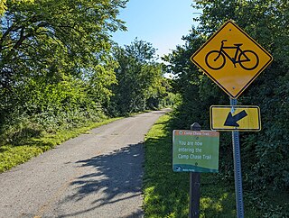
The Camp Chase Trail is a paved multi-use trail in Madison and Franklin counties in the U.S. state of Ohio. It serves as the Southwest Columbus segment of the 326-mile (525 km) Ohio to Erie Trail. The entire length of the Camp Chase Trail is part of the Great American Rail-Trail, U.S. Bicycle Route 21 and U.S. Bicycle Route 50.

The Northeast Texas Trail (NETT) is a planned 130+-mile multi-use trail along the route, following alongside U.S. Highway 82 and Texas State Highway 34. When complete, the trail will connect 19 cities spread over seven counties, stretching from the edge of the Dallas–Fort Worth metroplex to the Texarkana metropolitan area along the Arkansas border.


