
Porter County is a county in the U.S. state of Indiana. As of 2020, the population was 173,215, making it the 10th most populous county in Indiana. The county seat is Valparaiso. The county is part of Northwest Indiana, as well as the Chicago metropolitan area. Porter County is the site of much of the Indiana Dunes, an area of ecological significance. The Hour Glass Museum in Ogden Dunes documents the region's ecological significance.

Indiana Dunes National Park is a United States national park located in northwestern Indiana managed by the National Park Service. It was authorized by Congress in 1966 as the Indiana Dunes National Lakeshore and was redesignated as the nation's 61st national park on February 15, 2019. The park runs for about 20 miles (32 km) along the southern shore of Lake Michigan and covers 15,349 acres (6,212 ha). Along the lakefront, the eastern area is roughly the lake shore south to U.S. 12 or U.S. 20 between Michigan City, Indiana, on the east and the Cleveland-Cliffs steel plant on the west. This area's conservation scheme is enhanced by the older Indiana Dunes State Park. To the west of the steel plant lies West Beach and a small extension south of the steel mill continues west along Salt Creek to Indiana 249. The western area is roughly the shoreline south to U.S. 12 between the Burns Ditch west to Broadway in downtown Gary, Indiana. In addition, there are several outlying areas, including Pinhook Bog, in LaPorte County to the east; the Heron Rookery in Porter County, the center of the park; and the Calumet Prairie State Nature Preserve and the Hobart Prairie Grove, both in Lake County, the western end of the park.

The Kankakee River is a tributary of the Illinois River, approximately 133 miles (214 km) long, in the Central Corn Belt Plains of northwestern Indiana and northeastern Illinois in the United States. At one time, the river drained one of the largest wetlands in North America and furnished a significant portage between the Great Lakes and the Mississippi River. Significantly altered from its original channel, it flows through a primarily rural farming region of reclaimed cropland, south of Lake Michigan.

The Monon Trail is a rail trail located entirely within the state of Indiana. The Monon Railroad was a popular railroad line connecting the cities of Chicago and Indianapolis, with stops at major settlements along its route. After the decline of railroad travel and the sale of the company in 1987, the portion of the line between Indianapolis and Delphi, Indiana, was abandoned.
The Calumet Region is the geographic area drained by the Grand Calumet River and the Little Calumet River of northeastern Illinois and northwestern Indiana in the United States. It is part of the Great Lakes Basin, which eventually reaches the Atlantic Ocean. It is a sub-region of the greater Northwest Indiana region and the even larger Great Lakes region.
Northwest Indiana, nicknamed The Region after the Calumet Region, is an unofficial region of northern Indiana, United States that is located at the northwestern corner of the state. Though there is no official definition of the region, it is based on the Gary, Indiana Metropolitan Division, which comprises Jasper, Lake, Porter and Newton counties in Indiana, and the Michigan City-La Porte, IN Metropolitan Statistic Area, which comprises LaPorte, with unofficial definitions also including Starke and Pulaski counties. This region neighbors Lake Michigan and parts of it are in the Chicago metropolitan area. According to the 2020 Census, the largest definition of Northwest Indiana has a population of 866,965 and is the state's second largest urban area after the Indianapolis Metropolitan Area. It is also the home of the Indiana Dunes, parts of which have been preserved through conservation efforts. The town of Ogden Dunes houses the Hour Glass, a museum showcasing the ecological and conservation efforts of O. D. Frank.

The geography of Indiana comprises the physical features of the land and relative location of U.S. State of Indiana. Indiana is in the north-central United States and borders on Lake Michigan. Surrounding states are Michigan to the north and northeast, Illinois to the west, Kentucky to the south, and Ohio to the east. The entire southern boundary is the Ohio River.

Westchester Township is one of twelve townships in Porter County, Indiana. It is included in the Calumet, Northwest Indiana, and Great Lakes regions. It is located on the southern shore of Lake Michigan, about 50 miles (80 km) southeast of Chicago. It stretches from the famous Indiana Dunes on its northern border, south to the Valparaiso Moraine, a ridge of rolling hills left by the last glacier to pass through the area. As of the 2010 census, its population was 19,396.
Dune Park is a station in Westchester Township, Porter County, Indiana, located north of the municipalities of Chesterton and Porter. It is used by South Shore Line trains, and serves as the headquarters of the Northern Indiana Commuter Transportation District (NICTD), the umbrella agency that operates the South Shore Line. It is located at the intersection of U.S. Highway 12 and Indiana State Road 49.

The Valparaiso Moraine is a recessional moraine that forms an immense U around the southern Lake Michigan basin in North America. It is a band of hilly terrain composed of glacial till and sand. The Valparaiso Moraine defines part of the continental divide known as the Saint Lawrence River Divide, bounding the Great Lakes Basin. It begins near the border of Wisconsin and Illinois and extends south through Lake, McHenry, Cook, DuPage and Will counties in Illinois, and then turns southeast, going through northwestern Indiana. From this point, the moraine curves northeast through Lake, Porter, and LaPorte counties of Indiana into Michigan. It continues into Michigan as far as Montcalm County.

The Kankakee Outwash Plain is a flat plain interspersed with sand dunes in the Kankakee River valley in northwestern Indiana and northeastern Illinois of the United States. It is just south of the Valparaiso Moraine and was formed during the Wisconsin Glaciation. As the glacier stopped at the Valparaiso Moraine, its meltwater was carried away to the outwash plain. On the south side of the moraine, where the elevation drops, the meltwaters eroded away valleys, carrying sand and mud with them. As the muddy meltwater reached the valley where the slope lessened, the water slowed, depositing the sand on the outwash plain. This created a smooth, flat, and sandy plain. Before its draining, the Kankakee Marsh, located on the outwash plain, was one of the largest freshwater marshes in the United States.

Miller Beach is a neighborhood of Gary, Indiana on the southernmost shore of Lake Michigan. First settled in 1851, Miller Beach was originally an independent town. However, the "Town of Miller" was eventually annexed by the then flourishing city of Gary in 1918. Located in the northeastern corner of Lake County, Indiana, the former town is now known as "The Miller Beach Community." Miller Beach borders Lake Michigan to the north, Porter County to the east, and is largely surrounded by protected lands, including Indiana Dunes National Park. Miller Beach is also the closest beach/resort community to Chicago, and has been a popular vacation spot since the early 20th century. As of the 2000 US census, it had a population of 9,900.

The Great Lakes Circle Tour is a designated scenic road system connecting all of the Great Lakes and the St. Lawrence River. It consists of routes for circumnavigating the lakes, either individually or collectively. It was designated by the Great Lakes Commission in 1988.

The Heron Rookery in Porter County, Indiana, was set aside to protect the nesting grounds of the great blue heron. In 1980, the Indiana State Department of Correction transferred 69 acres (28 ha) to the National Park Service in exchange for 33 acres (13 ha) of land at Hoosier Prairie. In 1982, the Youth Conservation Corp constructed the trail and parking at the east side of the unit on County Road 600 E.

The Indiana Dunes comprise ten different habitats. Each provides for a unique combination of plants and animals. The range of the Indiana Dunes varies depending your source. The Indiana Lake Michigan Coastal Program uses the river drainage systems along the shoreline. This expands the area from the areas of lakeshore southward to the edges of the Valparaiso Moraine. This entire region has been dune landscapes since over 114,000 years before present (YBP). Traditionally, the Indiana Dunes area thought of as a narrow area along the shores of Lake Michigan, including the areas of Marquette Park in Gary, Indiana (1920), Indiana Dunes State Park (1926) and Indiana Dunes National Park,. The identified ten habitats can be found in these parks, where they have been preserved, but are also visible throughout the three counties of Northwest Indiana.

Baillytown is a former community in northern Porter County, Indiana, near the present-day communities of Porter and Burns Harbor. Although the town platted as the Town of Bailly was never built, the Baillytown name was used for many years to refer to the area around the original Joseph Bailly trading post. The name continues today as the name of a subdivision, constructed in the 1990s, in the town of Porter.

Ambridge Mann, sometimes called Ambridge-Horace Mann or Horace Mann-Ambridge, is a neighborhood in northwestern Gary, Indiana. It is bounded by the Grand Calumet River on the north, by Grant Street on the east, by Chase Street on the west, and by the Norfolk Southern railroad on the south. Adjacent areas include an industrial district to the north, Downtown West to the east, Tolleston to the south, and Brunswick to the west. As of 2000, Ambridge Mann had a population of 6,236, which was 96.3% African-American. Located just south of Interstate 90, the neighborhood can be seen while passing Buchanan Street.
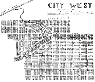
City West was a village in Porter County, Indiana, US, located on the shore of Lake Michigan approximately 10 miles west of Michigan City, Indiana. It was situated near the mouth of Fort Creek, now known as Dunes Creek, which empties into Lake Michigan near the Indiana Dunes State Park swimming beach. It was located near the former site of Petit Fort.
Indiana City was a notional community in northern Lake County, Indiana, at the mouth of the Grand Calumet River. It was located in present-day Marquette Park in Miller Beach, near the southern tip of Lake Michigan. Indiana City was one of a handful of early contenders to be a port city on southern Lake Michigan, alongside Chicago, City West, and Michigan City.

