Eldorado at Santa Fe, locally known as Eldorado, is a census-designated place (CDP) in Santa Fe County, New Mexico, United States. It is part of the Santa Fe, New Mexico Metropolitan Statistical Area. The population was 6,130 at the 2010 census.

Lamy is a census-designated place (CDP) in Santa Fe County, New Mexico, United States. Its population was 218 at the 2010 census. It is located approximately 18 miles (29 km) south of the city of Santa Fe.

The New Mexico Rail Runner Express is a commuter rail system serving the metropolitan areas of Albuquerque and Santa Fe, New Mexico. It is administered by the New Mexico Department of Transportation (NMDOT) and the Rio Metro Regional Transit District, a regional transportation agency, while Herzog Transit Services currently holds the contract for the operation and maintenance of the line & equipment. Phase I of the system, operating on an existing right-of-way from Belen to Bernalillo that NMDOT purchased from BNSF Railway, opened in July 2006. Phase II, the extension of the line to Santa Fe, opened in December 2008. Daily ridership, as of February 2019, was 2,200 trips per day. In 2023, the system had a ridership of 584,400, or about 1,900 per weekday as of the fourth quarter of 2023.

Santa Fe Depot in San Diego, California, is a union station built by the Atchison, Topeka and Santa Fe Railway to replace the small Victorian-style structure erected in 1887 for the California Southern Railroad Company. The Spanish Colonial Revival style station is listed on the National Register of Historic Places and is a San Diego Historic Landmark. Its architecture, particularly the signature twin domes, is often echoed in the design of modern buildings in Downtown San Diego.
Lamy station is an Amtrak station at Santa Fe County Road 33, 152 Old Lamy Trail in Lamy, New Mexico, United States. It is served by the Southwest Chief. It is also the southern terminus for the Sky Railway. The station was built in 1909 by the Atchison, Topeka and Santa Fe Railway.
Prairie Spirit Trail State Park is a rail trail that is a Kansas State Park.
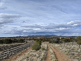
The Santa Fe Southern Railway is a short line railroad in New Mexico, United States. In addition to carrying freight on occasion, it also operates as a tourist railroad called Sky Railway that carries passengers between Lamy and Santa Fe: a distance of 18.1 miles (29.1 km). The Santa Fe Rail Trail, a multi-use trail, parallels its route.

The Rio Grande Trail is a proposed long distance trail along the Rio Grande in the U.S. state of New Mexico. The river extends over 1,800 total miles, some 700 miles (1,100 km) of which pass through the heart of New Mexico. It is the state's primary drainage feature and most valuable natural and cultural resource. The river and its bosque provide a wide variety of recreation, including hunting and fishing, birdwatching, river rafting, hiking, biking, and horseback riding. The river also flows through or beside numerous spectacular and geologically interesting landforms, the result of extensive volcanism and erosion of the valley within the Rio Grande Rift. Although some trail advocates would like to see the trail extended the full distance through New Mexico, from the Colorado border to the United States–Mexico border, the portion proposed for initial development extends 300 miles (480 km), from Bernalillo south to Las Cruces.

Santa Fe is the capital of the U.S. state of New Mexico. With a population of 87,505 at the 2020 census, it is the fourth-most populous city in the state. It is also the county seat of Santa Fe County. Its metropolitan area is part of the Albuquerque–Santa Fe–Las Vegas combined statistical area, which had a population of 1,162,523 in 2020. Human settlement dates back thousands of years in the region. The city was founded in 1610 as the capital of Nuevo México, replacing previous capitals at San Juan de los Caballeros and San Gabriel de Yunque; this makes it the oldest state capital in the United States.

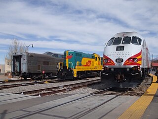
Santa Fe Depot is the northern terminus of the New Mexico Rail Runner Express commuter rail line. The station was originally built by the Atchison, Topeka and Santa Fe, and until 2014 served as the northern terminus, offices, and gift shop of the Santa Fe Southern Railway, a tourist and freight carrying short line railroad. It is located in Santa Fe, New Mexico at 410 Guadalupe Street, within an area of urban renewal referred to as the "Railyard". Rail Runner service to the station began on December 17, 2008.

South Capitol is a station on the New Mexico Rail Runner Express commuter rail line, located in Santa Fe, New Mexico at 1301 Alta Vista, between St. Francis Drive and Cerrillos Road, near the South Capitol Governmental Complex. It opened to service on December 17, 2008.

Zia Road is a station on the New Mexico Rail Runner Express commuter rail line, located in Santa Fe, New Mexico. The station is the first Rail Runner stop to be constructed on private land. Officials had scheduled it to open in August 2011, following an agreement from the city's finance committee that the stop will open if the owners construct parking and transit facilities for the station and the station opened in April 2017.
Santa Fe County/NM 599 is a station on the New Mexico Rail Runner Express commuter rail line, located southwest of Santa Fe, New Mexico, in Santa Fe County. It opened August 1, 2009.

NMDOT Park and Ride is the name given to a network of intercity buses in New Mexico and Texas, operated by the New Mexico Department of Transportation. The network is composed of eleven routes, including eight intercity routes and three local shuttle routes in Santa Fe, New Mexico. It is the fifth largest public bus transit operation in New Mexico based on ridership, with a yearly ridership of 315,738 for 2014. Service is provided in the morning and evening peak hours, with no service during midday, and buses operate on weekdays only.

The North Central Regional Transit District operates a network of several local and intercity bus routes in northern New Mexico, serving Santa Fe, Española, Taos, and many smaller communities along a network of 25 fixed routes and one demand-response route, one dial-a-ride and complementary Paratransit service in the Taos area. Routes operate Monday through Friday only, with the exceptions of the "Taos Express," which operates only on weekends, the Mountain Trail route to the Santa Fe National Forest and Ski Santa Fe, which operates daily, and seasonal daily service from the Town of Taos to Taos Ski Valley. All routes are fare-free, with the exception of the Taos Express and Mountain Trail route which are premium fare-based routes. The service is supported primarily by transit gross receipt taxes, which provides approximately 70% of the RTD's revenues. In 2023, the system had a ridership of 119,700, or about 300 per weekday as of the fourth quarter of 2023.

The Friendship Trail is a recreation trail in northeastern Wisconsin. The trail is used by walkers, hikers, bikers, horseback riders, and snowmobilers during the winter months. Two sections of the trail are complete: ~14 miles from Winchester east to Fox Crossing and ~4.4 miles from Forest Junction southeast to Brillion. The route consists of asphalt, crushed stone, and wood surfaces. The entire route is located in Winnebago County and Calumet County.

The Spurline Trail is a multi-use urban rail with trail which connects the cities of Waterloo and Kitchener, Ontario, Canada. Its northern trailhead is at the point where the CN Waterloo Spur crosses Laurel Creek; it connects to the Laurel Trail there, and is close to Uptown Waterloo. Its southern trailhead is at Ahrens Street West near its intersection with Breithaupt Street, close to Kitchener station and downtown Kitchener. The trail is 2.4 kilometres (1.5 mi) long, the entirety of which is paved. For its whole length, the trail runs parallel and to the north of the CN Waterloo Spur, stopping just short of where the Waterloo Spur joins the GO Transit Guelph Subdivision mainline at a junction just east of Kitchener station.

The Dale Ball Trail system is located at the foothills of the Sangre de Cristo Mountains, outside Santa Fe, New Mexico. A popular destination for hiking, trail running, and mountain biking, these trails vary in difficulty. Sections can be challenging for users not acclimatized to the altitude or climate. The trail system is well marked, junctions include section maps and arrows to nearby junctions.
Arroyo de los Chamisos Trail a trail in Santa Fe, New Mexico, connecting parks, schools, shopping and a community center. The trail is asphalted, approximately 3 miles long, and an important part of the Santa Fe urban trails system. It connects to the Santa Fe Rail Trail at its Northeast end near Siringo Road. At the Southwest end it branches into smaller local neighborhood trails, Villa Linda Park, and a local Mall.

The Beach Cities Greenway in Manhattan Beach and Hermosa Beach, California is a 3.9-mile (6.3 km) rail trail. The greenway is a linear park on the median between Valley Drive running along the west side and Ardmore Avenue on the east.
 Santa Fe Depot, with a Rail Runner Express train (right), alongside a diesel locomotive and ex-Santa Fe Pleasure Dome operated by the SFSR
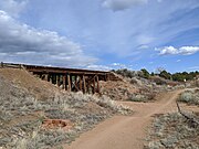 One of many trestle bridges along the trail. Here the trail has improved natural surface
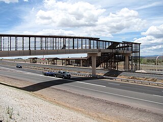
 Asphalted section near I-25