Related Research Articles
Canadian federalism involves the current nature and historical development of the federal system in Canada.
The Dominion Land Survey (DLS) is the method used to divide most of Western Canada into one-square-mile (2.6 km2) sections for agricultural and other purposes. It is based on the layout of the Public Land Survey System used in the United States, but has several differences. The DLS is the dominant survey method in the Prairie provinces, and it is also used in British Columbia along the Railway Belt, and in the Peace River Block in the northeast of the province.

Crowsnest Pass is a low mountain pass across the Continental Divide of the Canadian Rockies on the Alberta–British Columbia border.
The Saskatchewan Act, S. C. 1905, c. 42. is an Act of the Parliament of Canada which established the new province of Saskatchewan, effective September 1, 1905. Its long title is An Act to establish and provide for the government of the Province of Saskatchewan. The Act received royal assent on July 20, 1905. The Saskatchewan Act is part of the Constitution of Canada.

The Dominion Lands Act was an 1872 Canadian law that aimed to encourage the settlement of the Canadian Prairies and to help prevent the area being claimed by the United States. The Act was closely based on the United States Homestead Act of 1862, setting conditions in which the western lands could be settled and their natural resources developed.
Assiniboia District refers to two historical districts of Canada's North-West Territories. The name is taken from the Assiniboine First Nation.
The Canadian Northern Railway (CNoR) was a historic Canadian transcontinental railway. At its 1923 merger into the Canadian National Railway, the CNoR owned a main line between Quebec City and Vancouver via Ottawa, Winnipeg, and Edmonton.
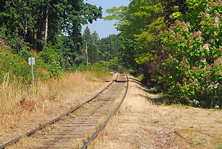
The Southern Railway of Vancouver Island is 234 kilometres (145 mi) in length, and is the only remaining railway on Vancouver Island, after the formal closure of the Englewood Railway in November 2017. The Southern Railway's railroad runs from Victoria to Courtenay, with a branch line from Parksville to Port Alberni. In 2006, the Island Corridor Foundation acquired the railway's ownership from the Canadian Pacific Railway and RailAmerica.
Northern Alberta Railways was a Canadian railway which served northern Alberta and northeastern British Columbia. Jointly owned by both Canadian National Railway and Canadian Pacific Railway, NAR existed as a separate company from 1929 until 1981.

The Peace River Country is an aspen parkland region centring on the Peace River in Canada. It extends from northwestern Alberta to the Rocky Mountains in northeastern British Columbia, where a certain portion of the region is also referred to as the Peace River Block.
The Peace River Block is an 3,500,000-acre (14,000 km2) area of land located in northeastern British Columbia, in the Peace River Country. In exchange for building a rail line across Canada to British Columbia the Canadian Pacific Railway was given the Railway Belt, 20 miles (32 km) on each side of the rail, of land. To compensate the CPR for alienated or non-arable land in the 40-mile (64 km) wide strip, the Province allowed the Dominion government to take control of 3,500,000 acres (14,000 km2) within B.C., northeast of the Rocky Mountains. This arrangement passed the provincial legislature on December 19, 1883, and passed the Dominion house on March 21, 1884, as the "Settlement Act". As all the land northeast of the Rocky Mountains became a provincial reserve pending the Dominion government's decision on what land to select prevented homesteading and land claims. After several surveys of the land the Dominion government took possession in 1907. The land the Dominion government chose was an approximately square-shaped block of land 72.4 miles (116.5 km) north-south and 75.7 miles (121.8 km) east-west. The south boundary begins at the intersection of the Alberta-British Columbia border and the Twentieth Baseline of the Dominion Land Survey and the north boundary begins at the Twenty-third Baseline, however both boundaries are run at right angles to the Alberta-British Columbia Border without accounting for meridian convergence and thus deviate south of each baseline. Land within the block was initially surveyed using the 3rd and 4th Systems of the Dominion Land Survey however much of the south and west parts of the block were eventually surveyed into district lots similar to other parts of British Columbia.

Alexander Duncan McRae, C.B., was a successful businessman, a Major General in the Canadian Army in First World War, a Member of Parliament, a Canadian Senator and a farmer.
The Natural Resources Acts were a series of Acts passed by the Parliament of Canada and the provinces of Alberta, British Columbia, Manitoba and Saskatchewan in 1930 to transfer control over crown lands and natural resources within these provinces from the federal government to the provincial governments. Alberta, Manitoba and Saskatchewan had not been given control over their natural resources when they entered Confederation, unlike the other Canadian provinces. British Columbia had surrendered certain portions of its natural resources and Crown lands to the federal government, the Railway Belt and the Peace River Block, when it entered Confederation in 1871, as part of the agreement for the building of the transcontinental railway.
The Canadian Pacific Railway is a Canadian Class I railway that stretches from Montreal, Quebec, to Vancouver, British Columbia. The British Columbia (BC) portion of the railway was constructed between 1881 and 1885, fulfilling a promise extended to BC when it entered Confederation in 1871. For decades, it was the only practical means of long–distance passenger transport in Canada.
The Pearce Estate Wetland is a city park located in Calgary, Alberta. The park occupies 21 hectares along the Bow River to the east of downtown Calgary. It is described as "constructed wetlands filled with native plants and animals". The land was donated to the city around 1929 by then prominent Calgarian William Pearce.
Land ownership in Canada is held by governments, Indigenous groups, corporations, and individuals. Canada is the second-largest country in the world by area; at 9,093,507 km² or 3,511,085 mi² of land it occupies more than 6% of the Earth's surface. Since Canada uses primarily English-derived common law, the holders of the land actually have land tenure rather than absolute ownership.
The Suffield Block is an area located within Cypress County, southern Alberta, Canada approximately bounded by Highway 884 on the west, Highway 555 on the north, the South Saskatchewan River on the east and the Trans-Canada Highway on the south. The Suffield Block is managed by CFB Suffield.
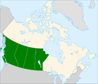
Western Canada, also referred to as the Western provinces and more commonly known as the West, is a region of Canada that includes the four provinces of Alberta, British Columbia, Manitoba, and Saskatchewan. British Columbia is culturally, economically, geographically, and politically distinct from the other parts of Western Canada and is often referred to as the "west coast" or "Pacific Canada", while Alberta, Saskatchewan, and Manitoba are sometimes grouped together as the Prairie Provinces and most commonly known as "The Prairies".
William Pearce (1848–1930), was a "surveyor, statistician, planner, and administrator in western Canada. He served in the federal government from 1874 to 1904 as federal surveyor and administrator, as federal advisor for western development and as Western consultant for the Canadian Pacific Railway Company. As Inspector of Dominion Lands Agencies, he oversaw the "development and allocation of all land, forests, mineral and water resources" from "Winnipeg to the eastern foothills of the Rockies"—representing 400,000 square miles of land, earning his nickname—"Czar of the West". He was known for his work on the Bow River watershed irrigation systems that transformed lands in southern Alberta into fertile land.
References
| This article about a location in the Interior of British Columbia, Canada is a stub. You can help Wikipedia by expanding it. |