Related Research Articles
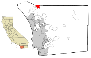
Rainbow is a census designated place (CDP) in northern San Diego County in the U.S. state of California. The population was 1,832 at the 2010 census, down from 2,026 at the 2000 census.

North County is a region in the northern area of San Diego County, California. It is the second-most populous region in the county, with an estimated population of 869,322. North County is well known for its affluence, especially in Encinitas, Carlsbad, Del Mar, Rancho Santa Fe, and Solana Beach, where house prices range, on average, above $1,000,000. Cities along the 78 freeway, which runs through the area, have more mixed incomes.

Sorrento Valley is a neighborhood of San Diego, California. It is located about 17 mi (27 km) north of Downtown San Diego and its main airport, Lindbergh Field. It is roughly bounded by Interstate 5 and Interstate 805, Camino Santa Fe to the east, the Los Peñasquitos Canyon Preserve to the north and Miramar Road to the south, as shown on the San Diego Police Department's neighborhood map. It encompasses Sorrento Mesa and is part of the San Diego Unified School District.
California's 48th congressional district is a congressional district in the U.S. state of California based in San Diego County in Southern California. It is currently represented by Republican Darrell Issa.
California's 40th congressional district is a congressional district in the U.S. state of California, encompassing Orange, San Bernardino, and Riverside counties. The district is currently represented by Republican Young Kim. It was one of 18 districts that would have voted for Joe Biden in the 2020 presidential election had they existed in their current configuration while being won or held by a Republican in 2022.

California's 53rd congressional district was a congressional district in the U.S. state of California. It was last represented by Sara Jacobs, who succeeded Susan Davis following the 2020 election. It was eliminated following the 2020 United States redistricting cycle.
KTMQ is an active rock radio station that serves the Temecula Valley and Inland Empire areas. The station is owned by iHeartMedia, Inc.

The Escondido Public Library is a public library system serving the city of Escondido, which is situated in San Diego County, California. The collection of the library contains 166,629 volumes, circulates 514,792 items per year and serves a population of 151,613 residents.

The Batiquitos Lagoon is a coastal wetland and estuary located between southern Carlsbad and Encinitas, in the North County region of San Diego County, California. The lagoon itself consists of 610 acres with a drainage basin of about 55,000 acres. Its primary freshwater tributaries being San Marcos Creek from the east and Encinitas Creek which flows north along Green Valley, entering the lagoon under El Camino Real and La Costa Avenue, respectively. It is one of the few remaining tidal wetlands on the southern California coast.
Pinacate, was a small settlement east of the Pinacate Mining District in Riverside County, California. It was established when the California Southern Railroad line was built between Colton and San Diego in 1882. Due to a land title dispute the town was moved to the north to become Perris, California, in 1885.
Serrano Creek is a roughly 7.5-mile (12.1 km) tributary of San Diego Creek in the U.S. state of California. The creek starts in the Santa Ana Mountains in a canyon in Whiting Ranch Wilderness Park, near the boundary of the Cleveland National Forest. It then flows southwest into the city of Lake Forest, running in a channelized course roughly parallel to Aliso Creek. It abruptly turns northwest then southwest at 90-degree angles as it enters a large storm drain that takes it the rest of the way to the confluence with the La Cañada Channel, creating the main stem of San Diego Creek.
Rancho Little Temecula was a 2,233-acre (9.04 km2) Mexican land grant in present-day Riverside County, California given in 1845 by Governor Pío Pico to Pablo Apis. The grant was one of the few held by indigenous people. The grant is south of present-day Temecula and is bordered on the north by Temecula Creek. At the time of the US patent, Rancho Little Temecula was a part of San Diego County. Riverside County was created by the California Legislature in 1893 by taking land from both San Bernardino and San Diego Counties.
Leon is a ghost town in northern San Diego County, California. A former gold mining town from the 1880s, it was named for the Leon Mine that lay on a hill to the northwest of the town. Leon became part of southwestern Riverside County in 1893. Leon had its own post office from May 4, 1888, until July 31, 1911, when its post office was moved to Perris, California.
Temescal Mountains, also known as the Sierra Temescal, are one of the northernmost mountain ranges of the Peninsular Ranges in western Riverside County, in Southern California in the United States. They extend for approximately 25 mi (40 km) southeast of the Santa Ana River east of the Elsinore Fault Zone to the Temecula Basin and form the western edge of the Perris Block.
Temescal Valley in California is a graben rift valley in western Riverside County, California, a part of the Elsinore Trough. The Elsinore Trough is a graben between the Santa Ana Mountain Block to the southwest and the Perris Block on the northeast. It is a complex graben, divided lengthwise into several smaller sections by transverse faults. The Temescal Valley is one of these graben, at the northern end of the trough. The Temescal Valley graben is bounded northeast side by the Lee Lake longitudinal fault and similarly on the southeast by the Glen Ivy Fault.
Radec is a small unincorporated community in Riverside County, California, United States. Located roughly 15 miles east by southeast of the city of Temecula, the community of Radec is located along Highway 79. Having bought land in the area in 1883, early settler Samuel Tripp set up a post office there. As of 1893–4, a local directory listed the area as growing honey, hay and stock, but also as having "no commercial interest of any kind." A total of 14 people, mainly farmers and beekeepers, plus a laborer and Tripp, are listed in the directory. The County of Riverside owns a small, non-operational cemetery in Radec.
The Carrizo Creek and Carrizo Wash in California are a stream and an arroyo that the stream flows into, in San Diego County, California, and Imperial County, California.
San Felipe Creek is a stream in Imperial and San Diego Counties of California. It arises in the Volcan Mountains of San Diego County 33°11′57″N116°37′35″W, and runs eastward, gathering the waters of most of the eastern slope of the mountains and desert of the county in the San Sebastian Marsh before it empties into the Salton Sea. It is probably the last remaining perennial natural desert stream in the Colorado Desert region. In 1974, the San Felipe Creek Area was designated as a National Natural Landmark by the National Park Service.
Bonita Creek is a stream in the city of Newport Beach, Orange County, California. It flows for about 3 miles (4.8 km) northwest from the San Joaquin Reservoir to its confluence with the San Diego Creek near Upper Newport Bay.
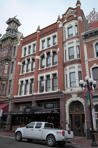
The Nesmith–Greely Building is a four-story historic structure located at 825 5th Avenue in San Diego's Gaslamp Quarter, in the U.S. state of California. It was built in 1888. It is located next to the Louis Bank of Commerce.
References
- ↑ U.S. Geological Survey Geographic Names Information System: Rainbow Valley
- ↑ A Man Called Rainbow by Vincent Nicholas Rossi, San Diego History Seeker; Exploring San Diego History, January 11, 2016 from sandiegohistoryseeker.com accessed April 15, 2016.
33°24′58″N117°08′53″W / 33.416°N 117.148°W
| | This Riverside County, California-related article is a stub. You can help Wikipedia by expanding it. |
| | This San Diego County, California–related article is a stub. You can help Wikipedia by expanding it. |