
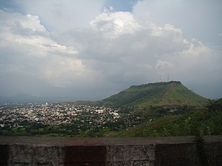
Lonavala-Khandala is a hill station and a Municipal Council in the Pune district, Maharashtra, India. It is about 64 km west of Pune and 96 km to the east of Mumbai. It is known for its production of the hard candy chikki and is also a major stop on the railway line connecting Mumbai and Pune. From the Pune suburbs, local trains are available from Pune Junction. Both the Mumbai-Pune Expressway as well as the Mumbai-Bengaluru highway pass through Lonavala.
Satara is a city located in the Satara District of Maharashtra state of India, near the confluence of the river Krishna and its tributary, the Venna. The city was established in the 16th century and was the seat of the Chhatrapati of Maratha Empire, Shahu I.

Osmanabad District officially known as Dharashiv District, is an administrative district in the Marathwada region in the Indian state of Maharashtra. The district headquarter is located at Osmanabad. The District of Osmanabad derives its name from the last ruler of Hyderabad, the 7th Nizam, Mir Osman Ali Khan, of which the region was a part till 1947. This region was earlier part of The Hyderabad State until Independence.This primarily rural district occupies an area of 7,569 km2 (2,922 sq mi) of which 241.4 km2 (93.2 sq mi) is urban and has a population of 1,657,576 of which 16.96% were urban.

Jijabai Bhonsle (or Bhonsale, Bhosale, Bhosle) or Jadhav, referred to as Rajmata, Rastramata, Jijabai, Jijamata or Jijau, was the mother of Chattrapati Shivaji, founder of the Maratha Empire. She was a daughter of Lakhujirao Jadhav of Sindkhed Raja.

Pune district is a district in Western Maharashtra with Administrative Headquarters in Pune city. Pune district is the most populous district in the Indian state of Maharashtra. It is one of the most industrialised districts in India.

Mahad ( [məɦaːɖ]) is a city in Raigad district situated in the North Konkan region of Maharashtra state, India. It is located 108.5 km (67.4 mi) from District Headquarters Alibag, and 167 km (104 mi) from Mumbai. Mahad is known for Raigad Fort, the capital of the Maratha Empire in Shivaji's era and the revolutionary Mahad Satyagraha launched by at Chavdar Tale in the wake of modern India.
Indapur is a town and a municipal council in Pune district in the Indian state of Maharashtra. Indapur is known for Jahagir of Chhatrapati Shivaji Maharaj's father and grandfather. Chhatrapati Shivaji Maharaj's grandfather Malojiraje died in battle in Indapur.
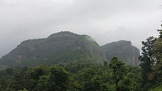
Sudhagad / Bhorapgad is a hill fort situated in Maharashtra, India. It lies about 53 kilometres (33 mi) west of Pune, 26 kilometres (16 mi) south of Lonavla and 11 kilometres (6.8 mi) east of Pali in Raigad District. The summit is 620 metres (2,030 ft) above sea level. The entire area around the fort is declared a Sudhagad wildlife sanctuary.
Mandangad is the headquarters of Mandangad taluka the northmost taluka in Ratnagiri district of Maharashtra, India.

Ramchandra Neelkanth Bawadekar (1650–1716), also known as Ramchandra Pant Amatya, served on the Council of 8 as the Finance Minister (Amatya) to Emperor (Chhatrapati) Shivaji, dating from 1674 to 1680. He then served as the Imperial Regent to four later emperors, namely Sambhaji, Rajaram, Shivaji II and Sambhaji II. He authored the Adnyapatra, a famous code of civil and military administration, and is renowned as one of the greatest civil administrators, diplomats and military strategists of the Maratha Empire.
Tulapur is a village in Pune district, Maharashtra, India, associated with the last moments of Sambhaji Maharaj, second Chatrapati of Hindavi Swarajya and son of Chatrapati Shivaji Maharaj.

Jedhe Karina or Jedhe Statement is a record of family events of Jedhe Deshmukh of village Kari located near Bhor in modern Pune district. It covers a period of about 65 years starting from 1626 and ending to 1689. While main objective of the Karina is to state how the family of Jedhes went on prospering day by day, it also throws light on the formative period of Maratha Empire.
Saswad is a municipal council located on South-Eastern corridor of Pune district of the Indian state of Maharashtra. Saswad is situated on the banks of the Karha River. Saswad is about 31 km from Pune-Central Station.

Shiv Jayanti, also known as Shivaji festival, is a festival and public holiday of the Indian state of Maharashtra. This festival is celebrated on February 19, celebrating the birth anniversary of Shivaji I, the first Chhatrapati of the Marathas. He established Hindavi Swarajya. Some people celebrate this day as per Hindu Calendar in Maharashtra.
Hindavi Swarajya is a term attributed to Shivaji, the founder of the Maratha Empire. After Shivaji's death, the term swarajya came into widespread use, without "Hindavi" but rather associated with "Maratha". According to André Wink, the term Maratha Swarajya meant a form of zamindari sovereignty, not necessarily attached to any particular territory.

Rohida fort / Vichitragad Fort is a fort located 10 km from Bhor, Pune district, of Maharashtra. This fort is an important fort in Pune district. The fort restoration is done by the Shree Shivdurga Samvardhan committee with the help of forest dept. and local villagers.

Kenjalgad Fort in Wai, Maharashtra is a fort eleven miles (18 km) north-west of Wai. It is located on the Mandhardev spur of the Mahadev hill range. The fort is visible from quite a long distance as a stone scarp 30–40 feet high rising as a cap on the irregular hill. The fort is rhomboid in shape with 388m long axis and 175m short axis.
Baghtos Kay Mujra Kar is a 2017 Indian Marathi-language political comedy-drama film which is directed by Hemant Dhome. It stars Jitendra Joshi, Aniket Vishwasrao and Akshay Tanksale in lead roles. The film was released on 3 February 2017.

Lalgun is a village in Khatav taluka of Satara district in the Indian state of Maharashtra. It is located on Pusegaon-Phaltan State Highway (SH-147) and comes under Koregaon Assembly constituency and Satara Lok Sabha constituency. Lalgun has a population of about 2930.


