
Himachal Pradesh is a state in the northern part of India. Situated in the Western Himalayas, it is one of the thirteen mountain states and is characterized by an extreme landscape featuring several peaks and extensive river systems. Himachal Pradesh is the northernmost state of India and shares borders with the union territories of Jammu and Kashmir and Ladakh to the north, and the states of Punjab to the west, Haryana to the southwest, Uttarakhand to the southeast and a very narrow border with Uttar Pradesh to the south. The state also shares an international border to the east with the Tibet Autonomous Region in China. Himachal Pradesh is also known as Dev Bhoomi, meaning 'Land of Gods' and Veer Bhoomi which means 'Land of the Brave'.

The Lahaul and Spiti district in the Indian state of Himachal Pradesh consists of the two formerly separate districts of Lahaul and Spiti. The present administrative center is Kyelang in Lahaul. Before the two districts were merged, Kardang was the capital of Lahaul, and Dhankar the capital of Spiti. The district was formed in 1960 and is the fourth least populous district in India. It is the least densely populated district of India, according to the Census of India 2011.

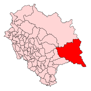
Kinnauri, also known as Kanauri, Kanor, Koonawur, Kanawari or Kunawar, is a Sino-Tibetan dialect cluster centered on the Kinnaur district of the Indian state of Himachal Pradesh.
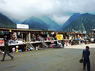
Reckong Peo, also spelled Rekong Peo or simply known as Peo by the local inhabitants, is headquarters of Kinnaur district, one of the twelve administrative districts of the Indian state of Himachal Pradesh.

Shimla district is one of the twelve districts of the state of Himachal Pradesh in northern India. Its headquarters is the state capital of Shimla. Neighbouring districts are Mandi and Kullu in the north, Kinnaur in the east, Uttarakhand in the southeast, Solan to the southwest and Sirmaur in the south. The elevation of the district ranges from 987 metres (3,238 ft) to 4,500 metres (14,764 ft).
The North Indian state of Himachal Pradesh is a state that has remained largely uninfluenced by Western culture. Himachal Pradesh is a multi-religion practising, multicultural and multilingual state. Some of the most commonly spoken languages are Hindi and the various Pahari languages. The Hindu communities residing in Himachal include the Brahmins, Rajputs, Kannets, Rathis and Kolis. There are also tribal population in the state which mainly comprise Gaddis, Kinnarms, Gujjars, Pangawals and Lahaulis.
Sangla is a town in the Baspa Valley, also referred to as the Sangla valley, in the Kinnaur District of Himachal Pradesh, India, close to the Tibetan border.

Baspa Valley is a river valley that is said to be named after the Baspa River. It lies in the Kinnaur District of Himachal Pradesh, India. Sangla is a major town in the Baspa Valley, and the valley is also known as the Sangla Valley or Tukpa Valley. The villages inside the valley is Chitkul, Rakchham, Batseri, Sangla, Kamru; the old capital of Bushahr State and Chansu.

Spiti is a high-altitude region of the Himalayas, located in the north-eastern part of the northern Indian state of Himachal Pradesh. The name "Spiti" means "The middle land", i.e. the land between Tibet and India. Spiti incorporates mainly the valley of the Spiti River, and the valleys of several rivers that feed into the Spiti River. Some of the prominent side-valleys in Spiti are the Pin valley and the Lingti valley. Spiti is bordered on the east by Tibet, on the north by Ladakh, on the west and southwest by Lahaul, on the south by Kullu, and on the southeast by Kinnaur. Spiti has a cold desert environment. The valley and its surrounding regions are among the least populated regions of India. The Bhoti-speaking local population follows Tibetan Buddhism.
The development of tribal areas in Himachal Pradesh is one of the major steps taken by the state government for its economic development. The border districts of Kinnaur, Lahaul, Spiti and the Pangi and Bharmour tehsils of Chamba districts are the major tribal areas of the state. They are located near the borders of Tibet and Indian States of Jammu and Kashmir. Other backward areas include Shillai in Sirmaur district, and deep cut-off valleys in the Kullu and upper stretches of Kangra districts. Due to poor accessibility, life in these areas had grown in isolation.

Chhitkul is a village in Kinnaur district of Himachal Pradesh. During winters, the place mostly remains covered with the snow and the inhabitants move to lower regions of Himachal.

Nako is a village in the Himalayas of northern India, located near the Indo-China border in the Trans-Himalayan region of Kinnaur district in Himachal Pradesh. Nako Lake is a prominent feature here where it borders the village. Nako Monastery, dated to 1025, is located in the village as well as several other Buddhist chortens.
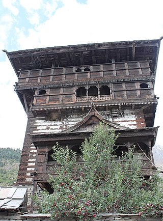
Kamru is a village located in the Sangla Valley of Kinnaur district, Himachal Pradesh, India. It sits c. 2,900 m above sea level and is about 2 km from the tourist town of Sangla, on the foot of Kinner-Kailash.
Tourism in Himachal Pradesh relates to tourism in the Indian state of Himachal Pradesh. This is popularly renowned for its Himalayan landscapes and popular hill-stations. Many outdoor activities such as rock climbing, mountain biking, paragliding, ice-skating, trekking, rafting, and heli-skiing are popular tourist attractions in Himachal Pradesh.
The Lamkhaga Pass is one of the toughest pass which connects Kinnaur district of Himachal Pradesh with Harshil in Uttarakhand. Harsil-Kharcham Highway will have a Lamkhaga Pass tunnel, and the highway route will also connect to Char Dham Highway and Pooh-Chumar-Hanle Highway.
Kinnaur Assembly constituency is one of the 68 assembly constituencies of Himachal Pradesh a northern Indian state. Kinnaur is also part of Mandi Lok Sabha constituency.
Batseri is a village in Sangla Valley in the Kinnaur district of Himachal Pradesh state of India.

Mud is a small village in the cold desert region of Spiti in Himachal Pradesh, India. Located at an altitude of 3,810 m (12,500 ft) on the left bank of the Pin River, a right bank tributary of the Spiti River, the village nestles at the base of the Parbati range that towers almost vertically 1,600 m (5,200 ft) above. Mud is near the boundary of the Pin Valley National Park and is a convenient base for treks in the park, and to the neighbouring districts of Kullu and Kinnaur. It is the last village on the Spiti side of the Pin Parbati trek to Kullu and the Pin Bhaba trek to Kinnaur.

Leo is a small village in Kinnaur district, Himachal Pradesh, India. The village is situated on a mountain ridge on the right bank of the Spiti River. It is located 116 kilometres (72 mi) from Kaza on NH 505.

