Related Research Articles
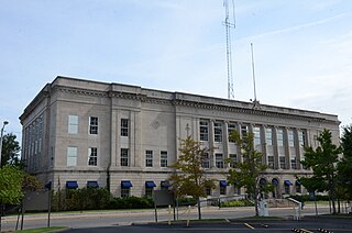
Muskogee County is a county located in the U.S. state of Oklahoma. As of the 2020 census, the population was 66,339. The county seat is Muskogee. The county and city were named for the Muscogee (Creek) Nation. The official spelling of the name was changed to Muskogee by the post office in 1900. Muskogee County is part of the Muskogee, OK micropolitan statistical area, which is included in the Tulsa-Muskogee-Bartlesville combined statistical area.

Washington County is a regional economic, educational, and cultural hub in the Northwest Arkansas region. Created as Arkansas's 17th county on November 30, 1848, Washington County has 13 incorporated municipalities, including Fayetteville, the county seat, and Springdale. The county is also the site of small towns, bedroom communities, and unincorporated places. The county is named for George Washington, the first President of the United States. Located within the Ozark Mountains, the county is roughly divided into two halves: the rolling Springfield Plateau in the more populous north of the county and the steeper, forested Boston Mountains in the much less populated south. It contains three segments of the Ozark National Forest, two state parks, two Wildlife Management Areas, the Garrett Hollow Natural Area, and dozens of city parks. Other historical features such as Civil War battlefields, log cabins, one-room school houses, community centers, and museums describe the history and culture of Washington County. Washington County occupies 951.72 square miles and contained a population of 245,871 people in 89,249 households as of the 2020 Census, ranking it 4th in size and 3rd in population among the state's 75 counties. The economy is largely based on the business/management, education, sales, office/administration, and poultry production industries. Poverty rates, median household income, and unemployment rates best state averages, but lag national trends. Washington County has long had a reputation for education in the state. The University of Arkansas, the largest four-year college in the state, was established in Fayetteville in 1871. A Washington County campus of the Northwest Arkansas Community College was opened in 2019 in Springdale. Today, Washington County contains eight public school districts, including two of the largest districts in the state and two private schools. It is included in the Fayetteville–Springdale–Rogers Metropolitan Statistical Area.

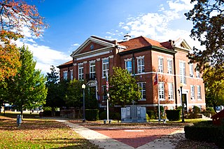
Prairie County is in the Central Arkansas region of the U.S. state of Arkansas. The county is named for the Grand Prairie, a subregion of the Arkansas Delta known for rice cultivation and aquaculture that runs through the county. Created as Arkansas's 54th county in 1846, Prairie County is home to four incorporated towns, including DeValls Bluff, the southern district county seat, and two incorporated cities, including Des Arc, the northern district county seat. The county is also the site of numerous unincorporated communities and ghost towns. Occupying 676 square miles (175,000 ha), Prairie County is the median-sized county in Arkansas. As of the 2020 Census, the county's population was 8,282. Based on population, the county is the ninth-smallest county of the 75 in Arkansas.
Boone County is a county located in the U.S. state of Arkansas, along the Missouri border. As of the 2020 census, the population was 37,373. The county seat is Harrison. It is Arkansas's 62nd county, formed on April 9, 1869.

DeWitt is the second largest city in Arkansas County, Arkansas, United States, which also serves as the county seat of the southern district of Arkansas County. Population was 3,292 at the time of the 2010 census. The city is located on the Arkansas Grand Prairie, known for rice farming and duck hunting. DeWitt is home to the DeWitt School District and the DeWitt Municipal Airport.

Zinc is a town near the east-central edge of Boone County, Arkansas, United States. The population was 92 at the 2020 census. It is part of the Harrison Micropolitan Statistical Area. A chapter of the Ku Klux Klan operates in Zinc.
Plumerville is a city in Conway County, Arkansas, United States. The population was 734 at the 2020 census.

Muskogee is the 13th-largest city in Oklahoma and is the county seat of Muskogee County. Home to Bacone College, it lies approximately 48 miles (77 km) southeast of Tulsa. The population of the city was 36,878 as of the 2020 census, a 6.0% decrease from 39,223 in 2010.

The Boston Mountains is a Level III ecoregion designated by the Environmental Protection Agency (EPA) in the U.S. states of Arkansas and Oklahoma. Part of the Ozarks, the Boston Mountains are a deeply dissected plateau. The ecoregion is steeper than the adjacent Springfield Plateau to the north, and bordered on the south by the Arkansas Valley. The Oklahoma portion of the range is locally referred to as the Cookson Hills. There are several theories of how the mountains were named, though apparently none are related to the Massachusetts city.

Green Country, sometimes referred to as Northeast Oklahoma, is the northeastern portion of the U.S. state of Oklahoma, which lies west of the northern half of Arkansas, the southwestern corner the way of Missouri, and south of Kansas.

The Verdigris River is a tributary of the Arkansas River in southeastern Kansas and northeastern Oklahoma in the United States. It is about 310 miles (500 km) long. Via the Arkansas, it is part of the Mississippi River watershed.

Stephen Wheeler Downey was a lawyer and politician in Wyoming. A Union Army veteran of the American Civil War, he was an early white settler of Wyoming, and served as its treasurer, auditor, and delegate to Congress. After statehood, Downey continued to serve in local and state office, including Speaker of the Wyoming House of Representatives.
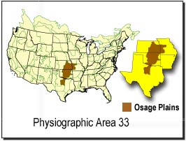
The Osage Plains are a physiographic section of the larger Central Lowland province, which in turn is part of the larger Interior Plains physiographic division. The area is sometimes called the Lower Plains, North Central Plains,or Rolling Plains. The Osage Plains, covering west-central Missouri, the southeastern third of Kansas, most of central Oklahoma, and extending into north-central Texas, is the southernmost of three tallgrass prairie physiographic areas. It grades into savanna and woodland to the east and south, and into shorter, mixed-grass prairie to the west. The Osage Plains consist of three subregions. The Osage Plains proper occupy the northeast segment. Although sharply demarcated from the Ozark uplift, the plains are nonetheless a transitional area across which the boundary between prairie and woodland has shifted over time. In the central portion of the physiographic area lies the second subregion, the Flint Hills, commonly called "the Osage" in Oklahoma. This large remnant core of native tallgrass prairie is a rocky rolling terrain that runs from north to south across Kansas and extends into Oklahoma. To the west and south of these hills are the Blackland Prairies and Cross Timbers. This vegetatively complex region of intermixed prairie and scrubby juniper-mesquite woodland extends into north-central Texas. Bluestem prairies and oak-dominated savannas and woodlands characterize the natural vegetation in the Cross Timbers. Much of the area has been converted to agriculture, although expanses of oak forest and woodland are still scattered throughout the eastern portion of the subregion.
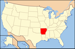
The following is an alphabetical list of articles related to the U.S. State of Arkansas.
Robert Thomas Hill was a significant figure in the development of American geology during the late 19th and early 20th centuries. As a pioneer Texas geologist, Hill discovered and named the Comanche series of the Lower Cretaceous, and was a lifelong student of the structure and stratigraphy of the Cretaceous deposits of Central Texas and neighboring regions.
The Watchung Outliers include six areas of isolated low hills and rock outcrops of volcanic and sedimentary origin in the U.S. states of New York, New Jersey, and Pennsylvania. These geologic outliers are primarily diminutive and detached remnants of the Triassic/Jurassic age Watchung Mountain basalt flows with intervening layers of sedimentary rock. All six of the outliers are found along the western edge of the Newark Basin, occupying small synclines adjacent to the Ramapo fault system. The outliers, from north to south, are known as: Ladentown, Union Hill, New Germantown/Oldwick, Prospect Hill, Sand Brook, and Jacksonwald.
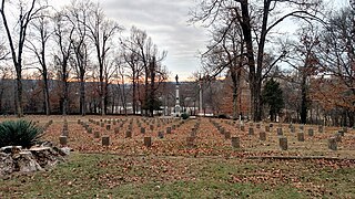
Fayetteville Confederate Cemetery is a cemetery for soldiers of the Confederate States located on the eastern side of Fayetteville in Washington County, Arkansas. Added to the National Register of Historic Places (NRHP) in 1993, the cemetery encompasses 3.5 acres (1.4 ha).

The Hale Formation is a geologic formation in northern Arkansas that dates to the Morrowan Series of the early Pennsylvanian. The Hale Formation has two named members: the Cane Hill and the Prairie Grove Members. The lower member is the Cane Hill, a primarily sandstone and shale interval that unconformably overlies the Mississippian-age Pitkin Formation. The upper member, the Prairie Grove Member, is predominately limestone and conformably underlies the Bloyd Formation.
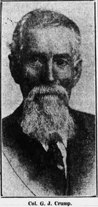
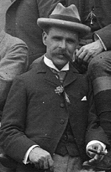
George James Crump was an officer in Confederate Army during the American Civil War, a lawyer, a state legislator for one term in the Arkansas House of Representatives and a public official. He also went by the name G. J. Crump.

Ripley "Rip" B. Weaver was a soldier, raiser of stock animals, state legislator, and government official from Arkansas. He served in the Arkansas House of Representatives and the Arkansas Senate, including as President of the Arkansas Senate. He was a Democrat.
References
- ↑ "Rally Hill". Geographic Names Information System . United States Geological Survey, United States Department of the Interior . Retrieved February 7, 2024.
- ↑ Benedict, John Downing (January 5, 1922). "Muskogee and Northeastern Oklahoma: Including the Counties of Muskogee, McIntosh, Wagoner, Cherokee, Sequoyah, Adair, Delaware, Mayes, Rogers, Washington, Nowata, Craig, and Ottawa". S.J. Clarke Publishing Company – via Google Books.
- ↑ Boone Co, AR. Turner Publishing Company. 1998. ISBN 978-1-56311-423-6.
- 1 2 "Skirmish at Rolling Prairie Historical Marker". www.hmdb.org.
- 1 2 Senate, Arkansas General Assembly (January 5, 1885). "Journal of the Senate of Arkansas" – via Google Books.
- ↑ Representatives, Arkansas General Assembly House of (January 5, 1885). "Journal ..." – via Google Books.
- ↑ "Southwestern Journal of Education". Wheeler & Osborn. January 5, 1889 – via Google Books.
- ↑ Hempstead, Fay (January 5, 1890). A Pictorial History of Arkansas: From Earliest Times to the Year 1890 ... Southern Historical Press. ISBN 978-0-89308-074-7 – via Google Books.
- ↑ Adams, George Irving (January 5, 1904). "Zinc and Lead Deposits of Northern Arkansas". U.S. Government Printing Office – via Google Books.
- ↑ Official Register of the United States: Containing a List of Officers and Employees in the Civil, Military, and Naval Service. U.S. Government Printing Office. 1872.
- ↑ Survey, 1887-1893, Arkansas Geological; Arkansas, Geological Survey of (January 5, 1894). "Report of the Geological Survey of Arkansas". Press Printing Company – via Google Books.
{{cite web}}: CS1 maint: numeric names: authors list (link) - ↑ "The Lead and Zinc News". 1901.
- ↑ Photo via https://sites.rootsweb.com/~arboone2/rallyhillacademyschool.html