
Ramona was the second generation Czechoslovak electronic support measures (ESM) system that uses measurements of time difference of arrival (TDOA) of pulses at three or four sites to accurately detect and track airborne emitters by multilateration.
Ramona was the second generation Czechoslovak electronic support measures (ESM) system that uses measurements of time difference of arrival (TDOA) of pulses at three or four sites to accurately detect and track airborne emitters by multilateration.
Ramona's designation was KRTP-81 and it carried the NATO reporting name of Soft Ball. The serial number was derived from the Czech phrase "Komplet radiotechnického průzkumu" meaning "Radiotechnical Reconnaissance Set". A later upgraded version was designated KRTP-81M. Ramona was deployed in 1979 and could semi-automatically track 20 targets simultaneously. It superseded Kopáč.
Each receiver comprised a large spherical radome mounted on the top of a 25 m fixed mast. This radome, made of identical segments of polyurethane foam, contained the radio antennas and the microwave components, intermediate frequency preamplifiers and the two-way communications equipment for communicating between central and side sites. At first glance the system bore a striking resemblance to typical Eastern European water towers.
The deployed system typically comprises a central site (containing the signal processing equipment and an ESM receiver) and two or three side sites containing only an ESM receiver. The side sites relay the signals received to the central site over a point-to-point microwave link. The central site uses the known propagation delay from the side sites to estimate the TDOA of the pulses at each site. The TDOA of a pulse between one side site and the central site locates the target on a hyperboloid. A second side site provides a second TDOA and hence a second hyperboloid. The intersection of these two hyperboloids places the target on a line, providing a 2D measurement of the target's location (no height).
Ramona operated over the frequency range of 0.8-18 GHz and provided surveillance over a sector of approximately 100 degrees. System deployment was complex and took between 4 and 12 hours. The system was transportable using thirteen Tatra T138 trucks.
17 Ramona systems and 14 upgraded Ramona-M systems were built. Of these, 14 Ramona and 10 upgraded systems were exported to the Soviet Union. Of these, the system with serial number 104 was deployed by the Soviet Union in North Korea. Other systems were exported to the German Democratic Republic. Syria received four (three Ramona-M) between 1981-94. One of these systems was deployed to Djebel Baruk in Lebanon. This site was first attacked by Israeli Air Force and then occupied by IDF during June 1982.
This article includes a list of references, related reading, or external links, but its sources remain unclear because it lacks inline citations .(December 2014) |

Signals intelligence (SIGINT) is the act and field of intelligence-gathering by interception of signals, whether communications between people or from electronic signals not directly used in communication. As classified and sensitive information is usually encrypted, signals intelligence may necessarily involve cryptanalysis. Traffic analysis—the study of who is signaling to whom and in what quantity—is also used to integrate information, and it may complement cryptanalysis.
In military telecommunications, electronic support (ES) or electronic support measures (ESM) gather intelligence through passive "listening" to electromagnetic radiations of military interest. They are an aspect of electronic warfare involving actions taken under direct control of an operational commander to detect, intercept, identify, locate, record, and/or analyze sources of radiated electromagnetic energy for the purposes of immediate threat recognition or longer-term operational planning. Thus, electronic support provides a source of information required for decisions involving electronic protection (EP), electronic attack (EA), avoidance, targeting, and other tactical employment of forces. Electronic support data can be used to produce signals intelligence (SIGINT), communications intelligence (COMINT) and electronics intelligence (ELINT).

PAVE PAWS is a complex Cold War early warning radar and computer system developed in 1980 to "detect and characterize a sea-launched ballistic missile attack against the United States". The first solid-state phased array deployed used a pair of Raytheon AN/FPS-115 phased array radar sets at each site to cover an azimuth angle of 240 degrees. Two sites were deployed in 1980 at the periphery of the contiguous United States, then two more in 1987–95 as part of the United States Space Surveillance Network. One system was sold to Taiwan and is still in service.
An active electronically scanned array (AESA) is a type of phased array antenna, which is a computer-controlled antenna array in which the beam of radio waves can be electronically steered to point in different directions without moving the antenna. In the AESA, each antenna element is connected to a small solid-state transmit/receive module (TRM) under the control of a computer, which performs the functions of a transmitter and/or receiver for the antenna. This contrasts with a passive electronically scanned array (PESA), in which all the antenna elements are connected to a single transmitter and/or receiver through phase shifters under the control of the computer. AESA's main use is in radar, and these are known as active phased array radar (APAR).

The Kolchuga passive sensor is an electronic-warfare support measures (ESM) system developed in the Soviet Union and manufactured in Ukraine. Its detection range is limited by line-of-sight but may be up to 800 km (500 mi) for very high altitude, very powerful emitters. Frequently referred to as Kolchuga Radar, the system is not really a radar, but an ESM system comprising three or four receivers, deployed tens of kilometres apart, which detect and track aircraft by triangulation and multilateration of their RF emissions.
Passive radar is a class of radar systems that detect and track objects by processing reflections from non-cooperative sources of illumination in the environment, such as commercial broadcast and communications signals. It is a specific case of bistatic radar – passive bistatic radar (PBR) – which is a broad type also including the exploitation of cooperative and non-cooperative radar transmitters.

The Erieye radar system is an Airborne Early Warning and Control System (AEW&C) developed by Saab Electronic Defence Systems, formerly Ericsson Microwave Systems, of Sweden. It uses active electronically scanned array (AESA) technology. The Erieye is used on a variety of aircraft platforms, such as the Saab 340 and Embraer R-99. It has recently been implemented on the Bombardier Global 6000 aircraft as the GlobalEye.

The VERA passive surveillance ESM system is an electronic support measures (ESM) system that uses measurements of time difference of arrival (TDOA) of pulses at three or four sites to accurately detect and track airborne emitters. The manufacturer is ERA a.s., based in Pardubice.
Kopáč was an early electronic warfare support measures (ESM) system developed in Czechoslovakia in the early 1960s that used measurements of time difference of arrival (TDOA) of pulses at three sites to accurately detect and track airborne emitters. The system used the principle of multilateration and was capable of simultaneously manually tracking up to six targets. It was first deployed in 1963 and was also known by its serial number, PRP-1. The initials PRP come from the Czech "Přesný radiotechnický pátrač", meaning "Accurate Radiotechnical Locator", the name comes from "Korelační pátrač", meaning "Correlation Locator".
Tamara was the third generation Czechoslovak electronic support measures (ESM) system that used measurements of time difference of arrival (TDOA) of pulses at three or four sites to accurately detect and track airborne emitters by multilateration. Tamara's designations were KRTP-86 and KRTP-91 and it carried the NATO reporting name of Trash Can. The designation was derived from the Czech phrase "Komplet Radiotechnického Průzkumu" meaning "Radiotechnical Reconnaissance Set". It was claimed to be the only one in the world able to detect military "invisible aircraft".
Pseudo-range multilateration, often simply multilateration (MLAT) when in context, is a technique for determining the position of an unknown point, such as a vehicle, based on measurement of the times of arrival (TOAs) of energy waves traveling between the unknown point and multiple stations at known locations. When the waves are transmitted by the vehicle, MLAT is used for surveillance; when the waves are transmitted by the stations, MLAT is used for navigation. In either case, the stations' clocks are assumed synchronized but the vehicle's clock is not.

An early-warning radar is any radar system used primarily for the long-range detection of its targets, i.e., allowing defences to be alerted as early as possible before the intruder reaches its target, giving the air defences the maximum time in which to operate. This contrasts with systems used primarily for tracking or gun laying, which tend to offer shorter ranges but offer much higher accuracy.
Berkeley Nucleonics Corporation (BNC) of San Rafael, California, United States, is an electronics company whose products range from pulse generators and digital delay generators to specialized handheld instruments and portal monitors capable of radiation detection and isotope identification.
Radar MASINT is a subdiscipline of measurement and signature intelligence (MASINT) and refers to intelligence gathering activities that bring together disparate elements that do not fit within the definitions of signals intelligence (SIGINT), imagery intelligence (IMINT), or human intelligence (HUMINT).

Wave radar is a type of radar for measuring wind waves. Several instruments based on a variety of different concepts and techniques are available, and these are all often called. This article, gives a brief description of the most common ground-based radar remote sensing techniques.

The PJT-531 Battle Field Surveillance Radar – Short Range(BFSR-SR) is a man portable 2D short-range battlefield and perimeter surveillance radar developed by the Indian Defence Research and Development Organisation (DRDO). The BFSR has been designed by DRDO's Bengaluru-based laboratory, the Electronics and Radar Development Establishment (LRDE) and is being manufactured by Bharat Electronics Limited (BEL).

The AN/FPS-20 was a widely used L band early warning and ground-controlled interception radar system employed by the United States Air Force Air Defense Command, the NORAD Pinetree Line in Canada, the USAF CONAD in the continental United States, and a variety of other users. The design started life as the Bendix AN/FPS-3 in 1950, was upgraded to the FPS-20, then spawned over a dozen different variants as additional upgrades were applied. The FPS-20 formed the backbone of the US air defense network through the early Cold War with over 200 units deployed. Most FPS-20 sites were replaced by modern equipment in the late 1960s, although a number were turned over to the FAA, modified for air traffic control use, and became ARSR-60s.
The Synchronous Impulse Reconstruction (SIRE) radar is a multiple-input, multiple-output (MIMO) radar system designed to detect landmines and improvised explosive devices (IEDs). It consists of a low frequency, impulse-based ultra-wideband (UWB) radar that uses 16 receivers with 2 transmitters at the ends of the 2 meter-wide receive array that send alternating, orthogonal waveforms into the ground and return signals reflected from targets in a given area. The SIRE radar system comes mounted on top of a vehicle and receives signals that form images that uncover up to 33 meters in the direction that the transmitters are facing. It is able to collect and process data as part of an affordable and lightweight package due to slow (40 MHz) yet inexpensive analog-to-digital (A/D) converters that sample the wide bandwidth of radar signals. It uses a GPS and Augmented Reality (AR) technology in conjunction with camera to create a live video stream with a more comprehensive visual display of the targets.
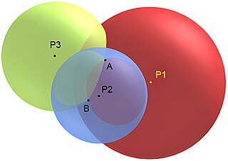
Trilateration is the use of distances for determining the unknown position coordinates of a point of interest, often around Earth (geopositioning). When more than three distances are involved, it may be called multilateration, for emphasis.
The AR-320 is a 3D early warning radar developed by the UK's Plessey in partnership with US-based ITT-Gilfillan. The system combined the receiver electronics, computer systems and displays of the earlier Plessey AR-3D with a Gilfillan-developed transmitter and planar array antenna from their S320 series. The main advantage over the AR-3D was the ability to shift frequencies to provide a level of frequency agility and thus improve its resistance to jamming.