Ranaghan Ranaghan | |
|---|---|
Town | |
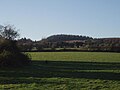
 Hills of Ranaghan | |
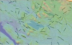
 Ranaghan Location in Ireland | |
| Coordinates: 53°38′50″N7°13′48″W / 53.64722°N 7.2301°W | |
| Country | Ireland |
| Province | Leinster |
| County | County Westmeath |
| Elevation | 128 m (420 ft) |
| merged with Castlepollard | |
| Time zone | UTC+0 (WET) |
| • Summer (DST) | UTC-1 (IST (WEST)) |
| Irish Grid Reference | N463640 |
Ranaghan is a townland and archaeological site in County Westmeath, Ireland.