
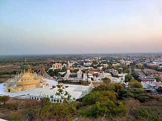
Porbandar is a city in the Indian state of Gujarat, perhaps best known for being the birthplace of Mahatma Gandhi and Sudama. It is the administrative center of the Porbandar District and it was the former capital of the Porbandar princely state.

Navsari is an administrative district in the state of Gujarat in India, with its headquarters at the city of Navsari. The district covers an area of 2,211 square kilometres and was formed in 1997 after Valsad district was split into Valsad and Navsari districts. It is the largest producer of chikoos in India.

Jamnagar District is a district of Gujarat in Western India. Its headquarters are located in the eponymous city of Jamnagar. It hosts the production facilities of large Indian companies such as Reliance. Among its attractions are several palaces, a Marine National Park and a Bird Sanctuary, known as Khijadiya Bird Sanctuary. In 2013, Devbhoomi Dwarka district was carved out of the western part of the district.
Bhavnagar District is a district of southeastern Gujarat, India, on the Saurashtra peninsula. The administrative headquarters is in the town of Bhavnagar.
Porbandar district is one of the 33 districts of Gujarat state in western India. The district covers an area of 2,316 km2. It had a population of 5.85,449 of which 48.77% were urban as of the 2011 census. This district was carved out of Junagadh district. It lies on the Kathiawar peninsula. Porbandar city is the administrative headquarters of this district. This district is surrounded by Jamnagar district and Devboomi Dwarka to the north, Junagadh district and Rajkot district to the east and the Arabian Sea to the west and south.

Rajkot district is one of the 33 districts of the Indian state of Gujarat. Located in Saurashtra peninsula, Rajkot city is the administrative headquarters of the district. It is the third-most advanced district in Gujarat and the fourth most populus.

Valsad district is one of the 33 districts in the Western Indian state of Gujarat. It is bound by Navsari district to the north, Nashik district of Maharashtra state to the east, and Dadra and Nagar Haveli district of the Dadra and Nagar Haveli and Daman and Diu (DNHDD) union territory and the Palghar district of Maharashtra to the south. The Arabian Sea lies west of the district. The coastal Damaon enclave of DNHDD is bounded by Valsad district on the north, east, and south. The district's administrative capital is Valsad. The district's largest city is Vapi.
Dhrangadhra is a town, taluka headquarters and a municipality in Surendranagar district in the state of Gujarat, India. During the period of the British Raj, the city was the capital of Dhrangadhra State, one of the eight first-class princely states of the Kathiawar Agency in the Bombay Presidency.

Veraval is a city and the headquarters of Gir Somnath district in the Indian state of Gujarat. Somnath temple, a place of pilgrimage due to its importance as Jyotirlinga site dedicated to Lord Shiva, is located here. It is also known for the hub of fishing industries in India.
Kutiyana is a city and a municipality in Porbandar district in the Indian state of Gujarat. It is situated on the banks of Bhadar River.
Adityana is a census town in Porbandar district in the India in state of Gujarat. It is located near Barda hills.
Chhaya is a city and a municipality in Porbandar district and Porbandar Taluka in the state of Gujarat, India.
Kodinar is a town and municipality in Gir Somnath district, in the Indian state of Gujarat, 37 kilometres (23 mi) west of Una. Kodinar is close to the Gir Forest National Park. The main transport connections for Kodinar are Diu Airport, Veraval Junction railway station, and Veraval Port.
Visavadar is a town and a municipality in Junagadh district in the Indian state of Gujarat.

Mer, Maher or Mehar is a caste from the Saurashtra region of Gujarat in India. They are largely based in the Porbandar district, comprising the low-lying, wetland Ghēḍ and highland Barḍā areas, and they speak a dialect of the Gujarati language. The Mers of the Ghēḍ and Barḍā form two groups of the jāti and together they are the main cultivators in the Porbandar District. Historically, the men served the Porbandar State as a feudal militia, led by Mer leaders. In the 1881 Gazette of the Bombay Presidency, the Mers were recorded numbering at 23,850. The 1951 Indian Census recorded 50,000 Mers. As of 1980 there were estimated to be around 250,000 Mers.
Patanvav is a large village 23 km from Dhoraji Town, 13 km from Upleta, 21 km from Manavadar, and 115 km from Rajkot by good motorable roads. It is in Dhoraji taluka of Rajkot district in Gujarat. Patanvav is at an elevation of 68 meters above mean sea level. Postal code is 360430. Dhoraji and Upleta towns are connected by railways on Rajkot-Jetalsar-Porbandar line. Village is situated in the foothills of the Osam Hills.
Kutiyana is one of the 182 Legislative Assembly constituencies of Gujarat state in India. It is part of Porbandar district.

Devda is a village in Porbandar district, Gujarat, India. It is on the bank of the Minsar river. The population of the village is around 4000 and most of people are doing farming. And major resources of farming water is wells and tube wells and major crops are cotton, groundnut, onion, and jira. Devda was also famous for its papaya and chilli but farmers no longer grow these crops.
Ashiyapat is a village in Ranavav Taluka of Porbandar district, Gujarat, India. It is about twenty miles north east of Porbandar.
Bhilleshwar is a village in Ranavav Taluka of Porbandar district in Gujarat, India.

