Related Research Articles
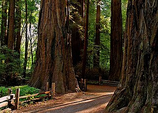
Henry Cowell Redwoods State Park is a state park of California, United States, preserving mainly forest and riparian areas in the watershed of the San Lorenzo River, including a grove of old-growth coast redwood. It is located in Santa Cruz County, primarily in the area between the cities of Santa Cruz and Scotts Valley, near the community of Felton and the University of California at Santa Cruz. The park includes a non-contiguous extension in the Fall Creek area north of Felton. The 4,623-acre (1,871 ha) park was established in 1953.

Rancho Rincón de los Esteros was a 6,353-acre (25.71 km2) Mexican land grant in present-day Santa Clara County, California.

The Redwood Grove of Henry Cowell Redwoods State Park, which is located in Santa Cruz County in Northern California, is a grove of Coast Redwoods with trees extending into the 1400- to 1800-year-old range. This grove allows for the use of self-guided tours of the flat, 0.8-mile (1.3 km) loop trail which is easily accessible. Dozens of large, Redwood trees are located within a few feet of the walking trail.
El Rancho Rinconada de los Gatos was a 6,631-acre (26.83 km2) Mexican land grant in present-day Santa Clara County, California made in 1840 by Governor Juan Alvarado to Jose Maria Hernandez and Sebastian Fabian Peralta. Located in the southern San Francisco Bay Area, the grant included present-day Los Gatos and Monte Sereno, along with about a third of Campbell. It also included small sections of present-day San Jose, Saratoga and unincorporated Santa Clara County. Los Gatos Creek flowed through the center of the rancho. The name means "corner of the cats" and is derived from the cougars that are still present in the nearby hills, as well as the "corner" formed by the narrowing gap between El Sereno and El Sombroso mountains.

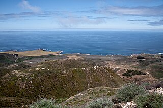
Wilder Ranch State Park is a California State Park on the Pacific Ocean coast north of Santa Cruz, California. The park was formerly a dairy ranch, and many of the ranch buildings have been restored for use as a museum. There are no campgrounds; a day-use parking lot provides access to the museum. Dogs are prohibited on the trails, but many trails allow bikes and/or horses. The long trails and ocean views make the area a favorite of hikers, equestrians and mountain bikers. Public beaches continue to the north in Coast Dairies State Park.

Rancho Rincón de los Bueyes was a 3,127-acre (12.65 km2) land grant in present-day Los Angeles County, California, given in 1821 to Bernardo Higuera and Cornelio Lopez by Pablo Vicente de Sola, the Spanish Governor of Alta California. In 1843, this Spanish grant was confirmed by Mexican Governor Manuel Micheltorena. Rincón, translated from Spanish, means corner or nook, and Bueyes are oxen or steer.

Thomas Benton Bishop was a well-known and successful San Francisco attorney.
Rancho El Rincón was a 4,431-acre (17.93 km2) Mexican land grant in present-day San Bernardino County and Riverside County, California given in 1839 to Juan Bandini by Governor Juan Alvarado. El rincón means "the corner" in Spanish. The grant, located south of present-day Chino, was bounded on the east by Rancho Jurupa, on the south by the Santa Ana River, on the west by Rancho Cañón de Santa Ana, and extending northerly from the river one league. The rancho lands include Prado Regional Park.
Rancho Santa Paula y Saticoy was a 17,773-acre (71.92 km2) Mexican land grant in the Santa Clara River Valley, in present-day Ventura County, California, and granted in 1843 by Governor Manuel Micheltorena to Manuel Jimeno Casarin. The rancho lands include the modern communities of Saticoy and Santa Paula along the Santa Clara River.
Rancho Primer Cañon o Rio de Los Berrendos was a 26,637-acre (107.80 km2) Mexican land grant in present day Tehama County, California given in 1844 by Governor Manuel Micheltorena to Job Francis Dye. Rio de Los Berrendos means River of the Antelopes. The grant was on the east side of the Sacramento River and was bounded by Antelope Creek on the north and Rancho Rio de los Molinos and Dye Creek on the south.
Rancho Rio de Jesus Maria was a 26,637-acre (107.80 km2) Mexican land grant in present-day Yolo County, California given in 1843 by Governor Manuel Micheltorena to Thomas M. Hardy. The name refers to Rio de Jesús María, now known as Cache Creek. The grant, north of Woodland, extended along Cache Creek, from Rancho Quesesosi on the east to the Sacramento River.
Rancho Los Coches was a 2,219-acre (8.98 km2) Mexican land grant in present-day Santa Clara County, California given in 1844 by Governor Manuel Micheltorena to Roberto Balemino, an Indian. The name means Ranch of the Pigs. The grant was located on the west bank of Los Gatos Creek, south of San Jose, near the present-day Burbank. The historic Roberto Adobe & Suñol House is located within the former rancho.

Rancho el Corte de Madera was a 13,316-acre (53.89 km2) Mexican land grant in present day Santa Clara County, California given in 1844 by Governor Manuel Micheltorena to Máximo Martínez. The name translates as "the place where lumber is cut". The roughly triangular shaped grant was west of today's I-280, and bounded on the north by Alambique Creek and San Francisquito Creek, on the south by Los Trancos Creek and Matadero Creek, and on the west by what is now Skyline Boulevard. The grant surrounded Rancho Cañada del Corte de Madera which extended along the Portola Valley. The land grant included parts of present day Woodside, Ladera and Stanford University.

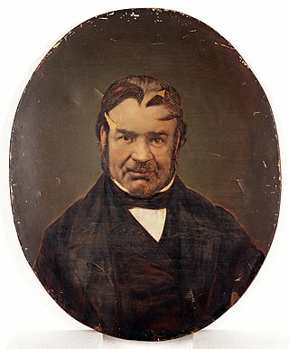
Don Pedro Sainsevain was a French-born Californian vintner, ranchero, and a signer of the Californian Constitution in 1849. He is best known for his role in Californian winemaking, as one of the first producers of sparkling wine in California. He also was an early participant in the California Gold Rush.

Rancho Omochumnes, also known as "Rancho Río de los Cosumnes al Norte", was a 18,662-acre (75.52 km2) Mexican land grant in present day Sacramento County, California.
Rancho Cañada de los Osos y Pecho y Islay was a 32,431-acre (131.24 km2) Mexican land grant in Los Osos Valley and the southern Estero Bay headlands, in present-day San Luis Obispo County, California.
Rancho Carbonera was a 2,225-acre (9.00 km2) Mexican land grant in present-day Santa Cruz County, California given in 1838 by Governor Juan B. Alvarado to William Buckle (Bocle). The grant was north of present-day Santa Cruz between the San Lorenzo River and Branciforte Creek. The southern section of Henry Cowell Redwoods State Park is within the Rancho.
Rancho Lomas de la Purificacion was a 13,341-acre (53.99 km2) Mexican land grant in present-day Santa Barbara County, California given in 1844 by Governor Manuel Micheltorena to Agustín Janssens. The name refers to the hills of Mission La Purísima Concepción. The grant extended between the Santa Ynez Mountains and the south bank of the Santa Ynez River opposite Rancho Cañada de los Pinos, and south east of Mission Santa Inés and present day Santa Ynez, in the Santa Ynez Valley.
Rancho Tres Ojos de Agua was a 176-acre (0.71 km2) Mexican land grant in present day Santa Cruz County, California given in 1844 by Governor Manuel Micheltorena to Nicolás Dodero. The name translates literally as "three eyes of water" (springs). The grant was located on both sides of present-day High Street around its intersection with Spring Street, in Santa Cruz.

Rancho Potrero Y Rincon de San Pedro Regalado was one of the smallest Mexican land grants in Alta California. Unlike the huge ranchos comprising tens of thousands of acres, this one was only 500 varas by 600 varas of the pasture land (potrero) originally belonging to Mission Santa Cruz.
References
- ↑ Ogden Hoffman, 1862, Reports of Land Cases Determined in the United States District Court for the Northern District of California, Numa Hubert, San Francisco
- ↑ Diseño del Rancho Cañada del Rincon en el Rio San Lorenzo
- ↑ Eugene T Sawyer, 1922, History of Santa Clara County California
- ↑ United States. District Court (California : Northern District) Land Case 90 ND
- ↑ United States. District Court (California : Southern District) Land Case 391 SD
- ↑ Finding Aid to the Documents Pertaining to the Adjudication of Private Land Claims in California, circa 1852-1892
- ↑ Report of the Surveyor General 1844 - 1886 Archived 2013-03-20 at the Wayback Machine
- ↑ Pinney, Thomas. 1989 A History of Wine in America: From the Beginnings to Prohibition. Berkeley: University of California Press, c1989
- ↑ Charles L. Sullivan , 1998, A Companion to California Wine: An Encyclopedia of Wine and Winemaking from the Mission Period to the Present , University of California Press, ISBN 978-0-520-21351-7
- ↑ Who was Henry Cowell?
- ↑ Davis v. California Powder Works, 1890, Reports of Cases determined in the Supreme Court of the State of California, 84 Cal. 617, Volume 84, pp.617-634 , Bancroft-Whitney Company
- ↑ California Powder Works v. Davis, U.S. Supreme Court, 151 U.S. 389 (1894)