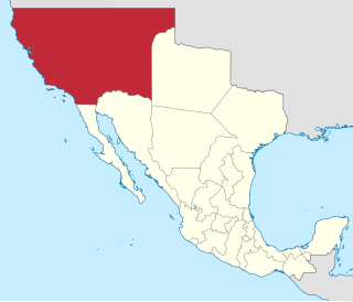
Alta California, also known as Nueva California among other names, was a province of New Spain formally established in 1804. Along with the Baja California peninsula, it had previously comprised the province of Las Californias, but was made a separate province in 1804. Following the Mexican War of Independence, it became a territory of Mexico in April 1822 and was renamed Alta California in 1824.

Tijuana is the most populous city in the state of Baja California, located on the northwestern Pacific Coast of Mexico. Tijuana is the municipal seat of the Tijuana Municipality and the hub of the Tijuana metropolitan area. It has a close proximity to the Mexico–United States border, which is part of the San Diego–Tijuana metro area.

Rosarito is a coastal city in Playas de Rosarito Municipality, Baja California, on the Pacific Coast of Mexico. As of 2010, the city had a population of 65,278. Located 10 miles (16 km) south of the US–Mexico border, Rosarito is a part of the greater San Diego–Tijuana region and one of the westernmost cities in Mexico. Rosarito is a major tourist destination, known for its beaches, resorts, and events like Baja Beach Fest.
Tecate is a city in Tecate Municipality, Baja California. It is across the Mexico–US border from Tecate, California. As of 2019, the city had a population of 108,860 inhabitants, while the metropolitan area has a population of 132,406 inhabitants. Tecate is part of the San Diego-Tijuana metropolitan region and the largest city between Tijuana and Mexicali. Tecate is a regional economic hub and popular tourist destination, known as home to the Tecate Port of Entry and to Tecate beer.
Juan María Marrón was an early settler of San Diego, California.
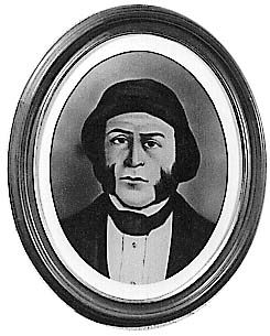
José María de Echeandía (?–1871) was the Mexican governor of Alta California from 1825 to 1831 and again from 1832 to 1833. He was the only governor of California that lived in San Diego.

José Antonio Castro was a Californio politician, statesman, and general who served as interim Governor of Alta California and later Governor of Baja California. During the Bear Flag Revolt and the American Conquest of California, Castro led Mexican forces as the Commandante General of Northern California.

In Alta California and Baja California, ranchos were concessions and land grants made by the Spanish and Mexican governments from 1775 to 1846. The Spanish Concessions of land were made to retired soldiers as an inducement for them to settle in the frontier. These Concessions reverted to the Spanish crown upon the death of the recipient.
The California Land Act of 1851, enacted following the Treaty of Guadalupe Hidalgo and the admission of California as a state in 1850, established a three-member Public Land Commission to determine the validity of prior Spanish and Mexican land grants. It required landowners who claimed title under the Mexican government to file their claim with a commission within two years. Contrary to the Treaty of Guadalupe Hidalgo, which guaranteed full protection of all property rights for Mexican citizens, it placed the burden on landholders to prove their title.
Rancho Ex-Mission San Diego was a 58,875-acre (238.26 km2) Mexican land grant in present-day San Diego County, California given in 1846 by Governor Pio Pico to Santiago Argüello. The rancho derives its name from the secularized Mission San Diego, and was called ex-Mission because of a division made of the lands held in the name of the Mission—the church retaining the grounds immediately around, and all of the lands outside of this are called ex-Mission lands. The grant extended eastward from the Pueblo San Diego to Rancho El Cajon, and encompassed present day east San Diego, Normal Heights, La Mesa, Lemon Grove, and Encanto.
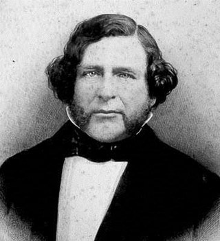
Santiago Argüello (1791–1862) was a Californio, a soldier in the Spanish army of the Viceroyalty of New Spain in Las Californias, a major Mexican land grant ranchos owner, and part of an influential family in Mexican Alta California and post-statehood California.
The following is a timeline of the history of the city of Tijuana, Baja California, Mexico.
Rancho Tía Juana, or Ti Juan was a land grant made to Santiago Arguello on March 4, 1829, by Governor José María de Echeandía. It covered 26,019.53 acres in what is now Tijuana in the Tijuana Municipality of Baja California, Mexico and parts of San Ysidro and the Tijuana River Valley, San Diego in South San Diego in San Diego County, California.
Rancho El Rosario, subsequently renamed Rancho Rosarito, was a land grant made to José Manuel Machado, one of the first soldiers stationed at the Presidio of San Diego. The grant was made in 1827, by Governor José María de Echeandía. It covered 11 leagues or 19,311 hectares in what is now Rosarito Beach Municipality of Baja California, Mexico, including the city of Rosarito Beach and other towns and localities in the municipality.
Rancho Tecate, or Rancho Cañada de Tecate was a land grant made to Juan Bandini in 1829, by the Mexican governor of Alta California, José María de Echeandía. He granted 4,439 acres of land in the valley of Tecate. A grant to Juan Bandini is recorded as being completed for Rancho Cañada de Tecate on July 12, 1834, under governor José Figueroa.
Rancho San Antonio Abad, a land grant in what is now the western part of Tijuana in the Tijuana Municipality of Baja California, Mexico. The name of the rancho derives from Saint Anthony the Abbot.
Santiago Emigdio Argüello (1813–1857), a Californio ranchero, civil servant, and military officer.
Rancho San Juan de Las Secuas also known as Rancho Secuan or Rancho Sequan was unusual in that it was originally a Mission land grant to Apolinaria Lorenzana and its next owner Juan Bautista Lopez failed in an attempt establish it as a Mexican land grant rancho of Alta California and abandoned it.
Rancho San Isidro Ajajolojol, also known as Rancho San Isidro Ajolojol, Rancho Joljol or Toljol or Rancho Jesus Maria or San Ysidro Ajajolojol, was a land grant made to José López in 1836 by interim Governor Nicolas Gutierrez.
