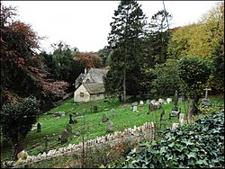
Randwick, Gloucestershire

Last updated
Randwick
Randwick, Gloucestershire. Churchyard.jpg
Randwick's Parish Church and Churchyard
Gloucestershire UK location map.svg
Red pog.svg
Randwick
Location within Gloucestershire
Population1,423 (2011 Census)
District
Shire county
Region
Country England
Sovereign state United Kingdom
Post town Stroud
Postcode district GL6
Police Gloucestershire
Fire Gloucestershire
Ambulance South Western
UK Parliament
List of places
UK
England
Gloucestershire
51°46′N2°15′W / 51.767°N 2.250°W / 51.767; -2.250

Randwick is a village bordering the market town of Stroud in Gloucestershire, England, the United Kingdom. It is known locally for its folk traditions such as the Randwick Wap, a celebration of May Day, and its annual pantomime.

Contents

The population at the 2011 census was 1,423. [1]

Governance

The village falls part of the 'Randwick, Whiteshill and Ruscombe' electoral ward. This ward stretches from Randwick north easterly to Whiteshill. The total ward population at the 2011 census was 1,747. [2]

The civil parish was renamed from Randwick to Randwick and Westrip on 1 August 2015. Westrip is an outer suburb of Stroud, south of Randwick, which may have been within the parish beforehand. [3]

Randwick Wap

The Wap is an annual series of events during spring which culminates in a traditional procession and festival dating back to the Middle Ages. Various theories exist on how it began, although most villagers believe it was a celebration that followed the completion of building Randwick's parish church.

The Wap was traditionally held on Low Sunday and Monday, the first Sunday and Monday after Easter. On the Sunday, the bells of the village church would be rung, a special service was held and a collection taken. On the Mon evening, a 'Mayor' was elected and he would be carried by chair to an ancient pool where he was immersed. Hordes would gather from far and wide including fiddle-playing and fortune-telling gipsies. [4] By the late 19th century, however, the Wap was becoming better known for its drunken revelry rather than as an ancient spectacle and it was evident that something had to be done. [5] In 1892, the church officials refused to ring the bells or hold a special collection to mark 'Wap Sunday' and although a mayor was elected, the Wap in its then form had run its course. [6]

The Randwick Wap was eventually revived in 1971 by the vicar Rev Niall Morrison (son of William Morrison, 1st Viscount Dunrossil) and now the festivities take place in the month of May. [7]

Related Research Articles

<span class="mw-page-title-main">Tewkesbury</span> Town and civil parish in England

Tewkesbury is a market town and civil parish in the north of Gloucestershire, England. The town grew following the construction of Tewkesbury Abbey in the twelfth century and played a significant role in the Wars of the Roses. It stands at the confluence of the River Severn and the River Avon, and thus became an important trading point, which continued as railways and, later, the M5 and M50 motorway connections were established. The town gives its name to the Borough of Tewkesbury, a local government district of Gloucestershire. The town lies on the border with Worcestershire, marked largely by the Carrant Brook.

<span class="mw-page-title-main">Stroud</span> Town in Gloucestershire, England

Stroud is a market town and civil parish in Gloucestershire, England. It is the main town in Stroud District. The town's population was 13,500 in 2021.

<span class="mw-page-title-main">Painswick</span> Human settlement in England

Painswick is a town and civil parish in the Stroud District in Gloucestershire, England. Originally the town grew from the wool trade, but it is now best known for its parish church's yew trees and the local Rococo Garden. The village is mainly constructed of locally quarried Cotswold stone. Many of the buildings feature south-facing attic rooms once used as weavers' workshops.

<span class="mw-page-title-main">Stroud District</span> Non-metropolitan district in England

Stroud District is a local government district in Gloucestershire, England. The district is named after its largest town of Stroud. The council is based at Ebley Mill in Cainscross. The district also includes the towns of Berkeley, Dursley, Nailsworth, Stonehouse and Wotton-under-Edge, along with numerous villages and surrounding rural areas. Over half of the district lies within the Cotswolds Area of Outstanding Natural Beauty.

<span class="mw-page-title-main">Nailsworth</span> Town in Gloucestershire, England

Nailsworth is a town and civil parish in the Stroud District in Gloucestershire, England, lying in one of the Stroud Valleys in the Cotswolds, on the A46 road, 4 miles (6.4 km) south of Stroud and about 25 miles (40 km) north-east of Bristol and Bath. The parish had a population of 5,794 at the 2011 census.

<span class="mw-page-title-main">Brockworth</span> Human settlement in England

Brockworth is a village and parish in the Borough of Tewkesbury, Gloucestershire, England, situated on the old Roman road that connects the City of Gloucester with Barnwood. It is located 4 miles (6.4 km) southeast of central Gloucester, 6 miles (9.7 km) southwest of Cheltenham and 11.5 miles (18.5 km) north of Stroud. The population taken at the 2011 census was 7,387. The population increased to 9,422 at the 2021 Census.

<span class="mw-page-title-main">Woodchester</span> Human settlement in England

Woodchester is a Gloucestershire village in the Nailsworth Valley, a valley in the South Cotswolds in England, running southwards from Stroud along the A46 road to Nailsworth. The parish population taken at the 2011 census was 1,206.

<span class="mw-page-title-main">Chalford</span> Human settlement in England

Chalford is a large village in the Frome Valley of the Cotswolds in Gloucestershire, England. It is to the southeast of Stroud about four miles upstream. It gives its name to Chalford parish, which covers the villages of Chalford, Chalford Hill, France Lynch, Bussage and Brownshill, spread over two square miles of the Cotswold countryside. At this point the valley is also called the Golden Valley.

<span class="mw-page-title-main">Stroud (UK Parliament constituency)</span> Parliamentary constituency in the United Kingdom, 1955 onwards

Stroud is a constituency represented in the House of Commons of the UK Parliament. It is held by Simon Opher of the Labour Party, who won the seat from Siobhan Baillie of the Conservatives in 2024. Formerly a safe Conservative seat, Stroud has been a marginal seat since 1997, changing hands five times in eight elections.

<span class="mw-page-title-main">Northleach</span> Market town in England

Northleach is a market town and former civil parish, now in parish Northleach with Eastington, in the Cotswold district, in Gloucestershire, England. The town is in the valley of the River Leach in the Cotswolds, about 10 miles (16 km) northeast of Cirencester and 11 miles (18 km) east-southeast of Cheltenham. The 2011 Census recorded the parish's population as 1,854, the same as Northleach built-up-area.

<span class="mw-page-title-main">Frampton on Severn</span> Human settlement in England

Frampton on Severn is a village and civil parish in Gloucestershire, England. The population is 1,432.

<span class="mw-page-title-main">Stone, Gloucestershire</span> Human settlement in England

Stone is a small village in the parish of Ham and Stone, Gloucestershire, England. It stands on the A38 road, just south-west of its crossing of the Little Avon River, roughly halfway between Bristol and Gloucester at grid reference ST684953. It is adjacent to the county boundary with South Gloucestershire. The part of the community just north-east of the river is called Woodford. In 2019 it had an estimated population of 527.

<span class="mw-page-title-main">Whiteshill, Stroud</span> Village in Gloucestershire, England

Whiteshill is a village in the Cotswolds, situated between Stroud and Gloucester, in Gloucestershire, England and forms part of the Stroud urban area. The parish of Whiteshill and Ruscombe has a population of 1,175.

<span class="mw-page-title-main">Hardwicke, Stroud</span> Human settlement in England

Hardwicke is a large village on the A38 road 7 km south of the city of Gloucester, Gloucestershire, England. Despite its proximity to Gloucester, the village comes under Stroud Council. The population of the village taken at the United Kingdom Census 2011 was 3,901.

<span class="mw-page-title-main">Martley</span> Human settlement in England

Martley is a village and civil parish in the Malvern Hills district of the English county of Worcestershire. It is approximately nine miles north-west of Worcester. The population of the village is approximately 1,200 people. The mixed farming of the area includes arable, formerly cherry, apple, damson orchards and hopyards.

Rodborough is a large village and civil parish in the district of Stroud, Gloucestershire, in South West England. It is directly south of the town of Stroud, north of the town of Nailsworth and north-west of the town of Minchinhampton. The parish includes the settlements of Bagpath, Butterrow, Kingscourt, Lightpill and Rooksmoor, and is adjacent to the Stroud suburb of Dudbridge. The population taken at the 2011 census was 5,334.

<span class="mw-page-title-main">Cainscross</span> Human settlement in England

Cainscross is a suburban town and civil parish in Gloucestershire, England, bordering the town of Stroud and forming part of the Stroud urban area. The parish includes the communities of Ebley, Cashes Green and Cainscross, and part of Dudbridge.

<span class="mw-page-title-main">Standish, Gloucestershire</span> Human settlement in England

Standish is a small village and civil parish in the Stroud local government district in Gloucestershire, England.

<span class="mw-page-title-main">Leonard Stanley</span> Human settlement in England

Leonard Stanley, or Stanley St.Leonard, is a village and parish in Gloucestershire, England, 95 miles (150 km) west of London and 3.5 miles (5.5 km) southwest of the town of Stroud. Situated beneath the Cotswold escarpment overlooking the Severn Vale, the surrounding land is mainly given over to agricultural use. The village is made up of some 600 houses and has an estimated population of 1,545 as of 2019. The hamlet of Stanley Downton lies less than a mile to the north and lies within the parish. In 1970, the village was twinned with the commune of Dozulé in the Calvados region of Normandy, northern France.

<span class="mw-page-title-main">Upton St Leonards</span> Human settlement in England

Upton St Leonards is a village in the English county of Gloucestershire. Forming part of the district of Stroud, it is a mile or so north of the A46 road between Stroud and Cheltenham.

References

  1. "Parish population 2011" . Retrieved 29 March 2015.
  2. "Randwick,Whiteshill and Randwick ward 2011" . Retrieved 30 March 2015.
  3. Gloucestershire Registration District, date of parish renaming
  4. "A Respected Randwickian Writes". Stroud News & Gloucestershire Advertiser. 11 April 1890. p. 4.
  5. "Wap". Stroud News & Gloucestershire Advertiser. 2 May 1868. p. 2.
  6. "Randwick". Stroud News & Gloucestershire Advertiser. 29 April 1892. p. 6.
  7. "It's Roll Out the Cheeses". Western Daily Press. 5 May 1975. p. 1.

51°46′N2°15′W / 51.767°N 2.250°W / 51.767; -2.250