
Thornborough is a village and also a civil parish within Aylesbury Vale district in Buckinghamshire, England. It is located about two miles east of Buckingham.

O'Brien's Bridge or O'Briensbridge is a village in east County Clare, Ireland, on the west bank of the River Shannon, in a civil parish of the same name. It is named for the bridge across the Shannon at that point, built by Turlough O'Brien in 1506.
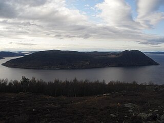
Ombo is the largest island in the Ryfylke region on the southwestern coast of Norway, and is the second largest island in Rogaland county. The 57.5-square-kilometre (22.2 sq mi) island of Ombo is divided between the municipalities Hjelmeland and Finnøy. There are several villages on the island including Jørstadvåg, Atlatveit, and Eidssund in the western part of the island which belongs to Finnøy municipality. The villages of Tuftene, Skipavik, Skår, and Vestersjø are located on the southeastern part of the island which belongs to Hjelmeland municipality. Jørstad Church is located in the village of Jørstadvåg.

Ballintoy is a small village, townland and civil parish in County Antrim, Northern Ireland. It is alongside the B15 coast road, 28 km (17 mi) north-east of Coleraine, 8 km (5.0 mi) west of Ballycastle and between it and Bushmills. It is in the historic barony of Cary. The village lies about one kilometre from Ballintoy Harbour, a small fishing harbour at the end of a very small, narrow, steep road down Knocksaughey hill which passes by the entrance to Larrybane and Carrick-a-Rede Rope Bridge. The harbour is host to a dawn service on Easter Sunday each year.

Whorlton is a small village in County Durham, in England. It is situated near the River Tees and to the east of Barnard Castle.

Dowra is a village in northwest County Cavan, Ireland. Nested to a valley on Lough Allen, it is the first village on, and marks the most uppermost navigable point of, the River Shannon. On one side of its bridge is County Cavan; on the other is County Leitrim. The nucleus of the village is situated in the Cavan side. It is located on the junction of the R200 and R207 regional roads.

Buildings, sites, districts, and objects in California listed on the National Register of Historic Places:
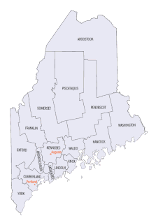
There are approximately 1,600 properties and districts listed on the National Register of Historic Places in the U.S. State of Maine. Each of the state's 16 counties has more than forty listings on the National Register.

This is a list of properties and districts listed on the National Register of Historic Places in New Jersey. There are more than 1,700 listed sites in New Jersey. All 21 counties in New Jersey have listings on the National Register.

This is a list of properties and districts listed on the National Register of Historic Places in Rhode Island. As of May 29, 2015, there are more than 750 listed sites in Rhode Island. All 5 of the counties in Rhode Island have listings on the National Register.

Entwistle is a hamlet in Alberta, Canada within Parkland County. It is located at the Yellowhead Highway's intersection with Highway 22/Highway 16A, approximately 95 kilometres (59 mi) west of Edmonton on the Yellowhead Highway. Entwistle sits on the east banks of the Pembina River near the halfway point between Edmonton and Edson.

Aughrim is a small town in County Wicklow, Ireland. It lies in a scenic valley in the east of Ireland where the Ow and Derry rivers meet to form the Aughrim river. Aughrim is on the R747 regional road which runs between Arklow and Baltinglass.

The Carrabassett River, a tributary of the Kennebec River, is located in Franklin County and Somerset County, Maine, in the United States. It rises near Sugarloaf Mountain, east of Rangeley Lake, and runs for 33.8 miles (54.4 km), flowing southeast past Kingfield and joining the Kennebec River in the town of Anson.
The R683 road is a regional road in Ireland. Located in the south of Ireland at Waterford, it connects the city to the village of Passage East, County Waterford and to County Wexford via a car ferry connection, which operates across the Waterford estuary between Passage East and the village of Ballyhack, County Wexford.
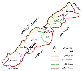
Khoda Afarin County is a county in East Azerbaijan Province in Iran. The capital of the county is Khomarlu. At the 2006 census, the county's population was 34,461, in 7,492 families. The county is subdivided into three districts: the Central District, Minjavan District, and Garamduz District. The county has one city: Khomarlu. Until 2011, The county was a district of Kaleybar county. Before the Islamic Revolution, Khomarlu was merely a village which was distinguished from other villages for housing the headquarters of Royal Gendarmery. The notary office was located in Abbasabad village and operated by a cleric, who also acted as the spiritual authority of the whole district.

Llanfrynach is a village and community in the county of Powys, Wales, and the historic county of Brecknockshire. The population of the community as taken at the 2011 census was 571. It lies just to the southeast of Brecon in the Brecon Beacons National Park. The village sits astride the Nant Menasgin, a right bank tributary of the River Usk. The B4558 passes just to its north and the Monmouthshire and Brecon Canal also passes around the village. The Welsh name signifies the 'church of Brynach'.
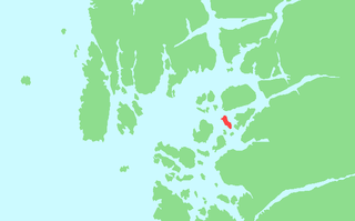
Halsnøya is an island in Finnøy municipality in Rogaland county, Norway. The 4.9-square-kilometre (1.9 sq mi) island is the largest island in of the Fisterøyene archipelago. Halsnøya is located south of the island of Ombo, southeast of the Sjernarøyane islands, east of the island of Finnøy, northeast of the island of Fogn, and west of the island of Randøy. The island is only accessible by boat, with regular ferry service from the nearby islands and to the mainland.

Fister is a former municipality in Rogaland county, Norway. The 47-square-kilometre (18 sq mi) municipality existed from 1884 until 1965. It was located in the present-day municipalities of Finnøy and Hjelmeland. The administrative centre of the municipality was the village of Fister, where the Fister Church is located. The municipality encompassed the western coast of mainland along the Fisterfjorden plus the islands to the west of the mainland, including the western part of Randøy and Halsnøya.


