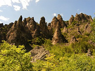
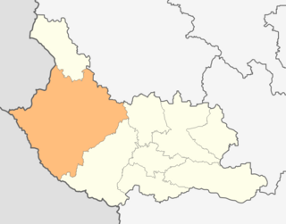
Kyustendil Province is a province in southwestern Bulgaria, extending over an area of 3,084.3 km2 (1,190.9 sq mi), and with a population of 107,673. It borders the provinces of Sofia, Pernik, and Blagoevgrad; to the west, its limits coincide with the state borders between Bulgaria and North Macedonia, and between Bulgaria and the Republic of Serbia. The administrative center of the Province is Kyustendil.

Bobov Dol is a town in Bobov Dol Municipality, Kyustendil Province, southwestern Bulgaria. Bobov Dol lies near the geographic centre of the Balkan Peninsula and is known for its coal mines and thermal power plant. The third-largest town in the province, it is the administrative centre of Bobov Dol municipality.

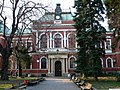
Kyustendil is a town in the far west of Bulgaria, the capital of the Kyustendil Province, a former bishopric and present Latin Catholic titular see.

Velbazhd Kyustendil is a Bulgarian professional association football club based in Kyustendil. The club currently competes in the A RFG Kyustendil, the fourth tier of Bulgarian football.
The 1998–99 A Group was the 51st season of the A Football Group, the top Bulgarian professional league for association football clubs, since its establishment in 1948.

Zemen is a town in Pernik Province, western Bulgaria. Located near the Pchelina Reservoir on the banks of the Struma River, it is the administrative centre of Zemen Municipality.

Kocherinovo is a town in southwestern Bulgaria, part of Kyustendil Province. It is the administrative centre of Kocherinovo Municipality, which lies in the southern part of Kyustendil Province. As of 2013 it had 2,255 inhabitants.

Rila is a town in southwestern Bulgaria, the administrative centre of Rila Municipality, in the southeastern part of Kyustendil Province.

Granitsa is a village in southwestern Bulgaria, part of Kyustendil Municipality, Kyustendil Province.

Žeravino or Zheravino is a divided village in easternmost Serbia and westernmost Bulgaria. The Bulgarian half of the village is part of Kyustendil municipality, Kyustendil Province, whereas the Serbian part belongs to Bosilegrad municipality, Pčinja District.

The Church of St George is a medieval Eastern Orthodox church in the city of Kyustendil, which lies in southwestern Bulgaria and is the administrative capital of Kyustendil Province. The church is located in the Kolusha neighbourhood, which was historically separate from the city. The church was constructed in the 10th–11th century and its frescoes are somewhat later, as the earliest layers were painted in the 11th–12th century.

E 871 is a European B class road in Bulgaria and North Macedonia, connecting the Kazanluk in Bulgaria and the city of Kumanovo in North Macedonia.
Kyustendil Municipality is a municipality in Kyustendil Province, Bulgaria. The administrative centre is Kyustendil.
Blatets is a village in Kyustendil Municipality, Kyustendil Province, south-western Bulgaria.
Garbino is a village in Kyustendil Municipality, Kyustendil Province, south-western Bulgaria.
Ivanovtsi is a village in Kyustendil Municipality, Kyustendil Province, south-western Bulgaria.
Lisets is a village in Kyustendil Municipality, Kyustendil Province, south-western Bulgaria.
Rasovo is a village in Kyustendil Municipality, Kyustendil Province, south-western Bulgaria.
Shishkovtsi is a village in Kyustendil Municipality, Kyustendil Province, south-western Bulgaria.
The 2000–01 Bulgarian Cup was the 61st season of the Bulgarian Cup. Litex Lovech won the competition, beating Velbazhd Kyustendil 1–0 in the final at the Stadion Lokomotiv in Sofia.