Ranomafana, Ifanadiana

Last updated
Ranomafana
Ranomafana 2015 02.JPG
Ranomafana
Madagascar location map.svg
Red pog.svg
Ranomafana
Location in Madagascar
Coordinates: 21°15′S47°27′E / 21.250°S 47.450°E / -21.250; 47.450
CountryFlag of Madagascar.svg  Madagascar
Region Vatovavy
District Ifanadiana
Area
[1]
  Total245 km2 (95 sq mi)
Elevation
[2]
400 −1,417 m (−4,249 ft)
Population
 (2018)
  Total9,705
Time zone UTC3 (EAT)
Postal code
312

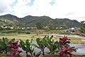
Ranomafana is a rural municipality in Madagascar. It belongs to the district of Ifanadiana, which is a part of the region of Vatovavy. The population of the commune was 9,705 in the 2018.

Contents

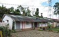
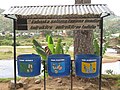
Primary and junior level secondary education are available in the town. 60% of the population of the commune are farmers; the most important crops are bananas and rice, while other important agricultural products are pineapple and cassava. Services provide employment for 40% of the population. [3]

Roads

The commune is situated at 62 km from Fianarantsoa and 138 km from Mananjary along the National Road 25.

Rivers

The municipality is crossed by the Namorona River. There are also the Andriamamovoka Falls, a waterfall on the Namorona near the fokontany of Vohiparara. [4]

Sights and Infrastructure

There is an outdoor swimming pool and bath filled by hot water springs. A well-kept park can be visited close to the outdoor pool. A number of hotels are found throughout the village, accommodating tourist that come to visit the nearby Ranomafana National Park. Ranomafana has a hospital. The Town Hall (Lapan'ny tanana) is on the main road. The Post Office and the Market are at Place de l'Indépendance where a memorial dedicated to the victims of the Malagasy Uprising of 1947 was erected. The Catholic Church was consecrated by bishop François Xavier Tabao Manjarimanana in 1988. [5] The Protestant Church is on a small hill offering a beautiful view of the town centre.

See also

Related Research Articles

<span class="mw-page-title-main">Glen Ellyn, Illinois</span> Village in Illinois, United States

Glen Ellyn is a village in DuPage County, Illinois, United States. A suburb located 24 miles (39 km) due west of downtown Chicago, the village has a population of 28,846 as of the 2020 Census.

<span class="mw-page-title-main">Arpajon</span> Commune in Île-de-France, France

Arpajon ( ) is a commune in the Essonne department in the Île-de-France region of northern France.

<span class="mw-page-title-main">Hvolsvöllur</span> Town in South Constituency, Iceland

Hvolsvöllur is a town in the south of Iceland about 106 km to the east of Reykjavík.

The Village of Nakusp is located south of the mouth of Kuskanax Creek, on the Upper Arrow Lake in the West Kootenay region of southeastern British Columbia. Lying between the Selkirk and Monashee ranges, the village is known for its nearby hot springs and picturesque mountain lakeside setting.

<span class="mw-page-title-main">Ergoldsbach</span> Municipality in Bavaria, Germany

Ergoldsbach is a municipality in Bavaria, about 20 km north of Landshut and 80 km northeast of Munich in Germany.

<span class="mw-page-title-main">Fianarantsoa</span> Place in Haute Matsiatra, Madagascar

Fianarantsoa is a city in south central Madagascar, and is the capital of Haute Matsiatra Region.

<span class="mw-page-title-main">Merzig</span> Town in Saarland, Germany

Merzig is a town in Saarland, Germany. It is the capital of the district Merzig-Wadern, with about 30,000 inhabitants in 17 municipalities on 108 km². It is situated on the river Saar, approx. 35 km south of Trier, and 35 km northwest of Saarbrücken.

<span class="mw-page-title-main">Maintirano</span> Place in Melaky, Madagascar

Maintirano is a coastal city, commune urbaine, and Catholic bishopric in western Madagascar approximately 325 kilometres west of the capital Antananarivo. It belongs to the district of Maintirano, which is a part of Melaky Region – and is capital of both.

<span class="mw-page-title-main">Ranomafana National Park</span> National park in Madagascar

Ranomafana National Park is a national park in southeastern Madagascar, in the Haute Matsiatra and Vatovavy regions. It was established as Madagascar's fourth national park in 1991 following the rediscovery of the greater bamboo lemur and the discovery of the golden bamboo lemur by the primatologist Dr. Patricia Wright.

<span class="mw-page-title-main">Kötschach-Mauthen</span> Place in Carinthia, Austria

Kötschach-Mauthen is a market town in the district of Hermagor in Carinthia in Austria.

<span class="mw-page-title-main">Vauvert</span> Commune in Occitania, France

Vauvert is a commune in the far south of the Gard department in southern France. It was known as Posquières in the Middle Ages. The commune comprises the town of Vauvert and the villages of Gallician and Montcalm. Over a third of the population work in industry, which is largely the food industry, especially wine production. The original settlement was called Posquières and was first mentioned in a document of 810. Since then the town has increased in importance and has had a rich history. At its heyday in the mid-nineteenth century it had a population of 6,000 but this decreased by a third after disease struck the grape crop, the mainstay of the economy of the area. Today, the population has grown again to over 11,000.

The municipality of Boñar is located in the province of León, Castile and León, Spain. As per the 2010 census (INE), the municipality has a population of 2,085 inhabitants with almost all of the residents living in the main town of Boñar. In addition to Boñar, the municipality includes the villages of Adrados, Barrio de las Ollas, Las Bodas, Cerecedo, Colle, Llama, Felechas, Grandoso, Orones, Oville, Poblado del Pantano, Remellán, Rucayo, Valdecastillo, Valdehuesa, La Vega de Boñar, Veneros, Vozmediano, and Voznuevo. Most surrounding villages in the municipality of Boñar have between 10 and 30 permanent residents, but some of the larger villages have up to 250 villagers.

<span class="mw-page-title-main">Baltanás</span> Municipality in Castile and León, Spain

Baltanás is a municipality located in the province of Palencia, Castile and León, Spain. According to the 2021 census (INE), the municipality had a population of 1,219 inhabitants.

<span class="mw-page-title-main">Baldenheim</span> Commune in Grand Est, France

Baldenheim is a commune in the Bas-Rhin department in the Alsace region of north-eastern France.

<span class="mw-page-title-main">Mousseaux-sur-Seine</span> Commune in Île-de-France, France

Mousseaux-sur-Seine is a commune in the Yvelines department in the Île-de-France region in north-central France.

<span class="mw-page-title-main">Ranohira</span> Place in Ihorombe, Madagascar

Ranohira is a town and commune in Madagascar. It belongs to the district of Ihosy, which is a part of Ihorombe Region. The population of the commune was 16,041 in 2018. The nearest towns are Ilakaka at 26 km and Ihosy 93 km distance.

Androrangavola is a rural municipality in Madagascar. It belongs to the district of Ifanadiana, which is a part of Vatovavy. The population of this municipality was 14,709 inhabitants in 2018.

Kelilalina is a town and commune in Madagascar. It belongs to the district of Ifanadiana, which is a part of Vatovavy. This municipality has a population of 10,747 inhabitants in 2018.

Ranomafana is a rural municipality in Madagascar. It belongs to the district of Taolanaro, which is a part of Anosy Region. The population of the commune was estimated to be approximately 11,000 in 2001 commune census.

Fandriana is an urban commune in Central Highlands of Madagascar. It belongs to the district of Fandriana, which is a part of Amoron'i Mania Region. It has a population of 29,232 inhabitants (2018).

References

  1. RAMAMONJISOA, 2014. ARBORETUM COMMUNAL ET INTEGRATION AU DEVELOPPEMENT DURABLE - COMMUNE RURALE DE RANOMAFANA
  2. Estimated based on DEM data from Shuttle Radar Topography Mission
  3. "ILO census data". Cornell University. 2002. Retrieved 2008-05-03.
  4. L'Express.mg: Ranomafana: Un homme glisse dans une cascade
  5. Commemorative stone at the church, to be seen at Wikipedia Commons

21°15′S47°27′E / 21.250°S 47.450°E / -21.250; 47.450