Related Research Articles

Missouri generally has a variety of seasonal humid subtropical climate, with cool winters and long, hot summers. In the southern part of the state, particularly in the Bootheel, the climate borders on a more mild-type humid subtropical climate, and in the northern third, the state transitions into a humid continental climate. Because of its location in the interior United States, Missouri often experiences extremes in temperatures. Lacking either large mountains or oceans nearby to moderate its temperature, its climate is alternately influenced by air from the cold Arctic and the hot and humid Gulf of Mexico.

Port Sudan is a port city on the Red Sea in eastern Sudan, and the capital of Red Sea State. Port Sudan is Sudan's main seaport and the source of 90% of the country's international trade. The population of Port Sudan was estimated in the 2008 Census of Sudan to be 394,561 people.

Bandar Lengeh is a city in the Central District of Bandar Lengeh County, Hormozgan province, Iran, serving as capital of both the county and the district.

Atbara is a city located in River Nile State in northeastern Sudan.

Iranshahr is a city in the Central District of Iranshahr County, Sistan and Baluchestan province, Iran, serving as capital of the province, the county, and the district.

Kaduqli or Kadugli is the capital city of South Kordofan State, Sudan. It is located 240 kilometres (150 mi) south of El-Obeid, at the northern edge of the White Nile plain in the Nuba Mountains. It contains Hilal Stadium.

The East Sudanian savanna is a hot, seasonally dry tropical savanna ecoregion of Central and East Africa.
En Nahud is a town in the desert of central Sudan. Formerly located within the Sudanese political division of West Kurdufan, it is now part of the country's North Kurdufan state.

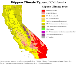
The climate of California varies widely from hot desert to alpine tundra, depending on latitude, elevation, and proximity to the Pacific Coast. California's coastal regions, the Sierra Nevada foothills, and much of the Central Valley have a Mediterranean climate, with warmer, drier weather in summer and cooler, wetter weather in winter. The influence of the ocean generally moderates temperature extremes, creating warmer winters and substantially cooler summers in coastal areas.

Antalaha is an urban municipality in northern Madagascar. It belongs to the district of Antalaha, which is a part of Sava Region. The population of Antalaha was 67.888 in 2018.

Sambava is a city and commune at the east coast of northern Madagascar. It is the capital of Sambava District and Sava Region. The population of the commune was 84,039 in as of the 2018 commune census.

The climate of Pennsylvania is diverse due to the multitude of geographic features found within the state. Straddling two major climate zones, the southeastern corner of Pennsylvania has the warmest climate. A portion of Greater Philadelphia lies at the southernmost tip of the humid continental climate zone, with the city proper being in the humid subtropical climate zone. Still, Philadelphia features colder, snowier winters than most locations with a humid subtropical climate. Moving west toward the mountainous interior of the state, the climate becomes markedly colder, the number of cloudy days increases, and winter snowfall amounts are greater.

The climate of Russia is formed under the influence of several determining factors. The enormous size of the country and the remoteness of many areas from the sea result in the dominance of the continental climate, which is prevalent in European and Asian Russia except for the tundra and the extreme southwest. Mountains in the south obstructing the flow of warm air masses from the Indian Ocean and the plain of the west and north makes the country open to Arctic and Atlantic influences. Russia's climate, despite its enormous geographical extent, is generally warm to hot in the summer and cold to very cold in the winter, with snow cover typically present over the vast majority of the country's territory in the winter months, with the exception of the country's southernmost territories, the North Caucasus. Russia's far northeast, subject to an extreme subarctic climate, experiences the coldest winters of any permanently settled region in the world, with Yakutsk, the capital of the Sakha Republic, being the world's coldest major city and Oymyakon, also in the Sakha Republic, being the world's coldest permanently inhabited settlement.

The climate of New Jersey classification of the U.S. state of New Jersey is humid subtropical in South Jersey with a humid continental climate in North Jersey, particularly in the northwestern area of the state. The northwest part of New Jersey is the snowiest due to the higher elevations that earn it a Dfb classification. During the winters, New Jersey can experience Nor'easters, which are snowstorms that affect the Northeastern United States, and Atlantic Canada. However, many would-be snow events in the state end up turning to rain due to warm ocean air being brought in by the storm. New Jersey's climate is shaped by its proximity to the Atlantic Ocean which provides moisture and moderates temperatures. According to climatology research by the U.S. National Oceanic and Atmospheric Administration, New Jersey has been the fastest-warming state by average air temperature over a 100-year period beginning in the early 20th century, related to global warming.
Babanusa is a town in western Sudan.

Abetifi is a small town in south Ghana and is the capital of Kwahu East district, a district in the Eastern Region of south Ghana.

The climate of New England varies greatly across its 500-mile (800 km) span from northern Maine to southern Connecticut.
References
- ↑ "Districts of Sudan". statoids. Retrieved 29 December 2018.
- ↑ "list of districts of Sudan" (PDF). Download Excel Files. Retrieved 29 December 2018.
- ↑ "Station Name: RASHAD" (TXT). National Oceanic and Atmospheric Administration. Retrieved 30 August 2024.
- ↑ "Rashad Climate Normals 1991–2020". World Meteorological Organization Climatological Standard Normals (1991–2020). National Oceanic and Atmospheric Administration. Archived from the original on 25 September 2023. Retrieved 25 September 2023.