
Geodesy is the Earth science of accurately measuring and understanding Earth's figure, orientation in space, and gravity. The field also incorporates studies of how these properties change over time and equivalent measurements for other planets. Geodynamical phenomena, including crustal motion, tides and polar motion, can be studied by designing global and national control networks, applying space geodesy and terrestrial geodetic techniques and relying on datums and coordinate systems. The job title is geodesist or geodetic surveyor.

Navigation is a field of study that focuses on the process of monitoring and controlling the movement of a craft or vehicle from one place to another. The field of navigation includes four general categories: land navigation, marine navigation, aeronautic navigation, and space navigation.

In mathematics, a spherical coordinate system is a coordinate system for three-dimensional space where the position of a point is specified by three numbers: the radial distance of that point from a fixed origin, its polar angle measured from a fixed zenith direction, and the azimuthal angle of its orthogonal projection on a reference plane that passes through the origin and is orthogonal to the zenith, measured from a fixed reference direction on that plane. It can be seen as the three-dimensional version of the polar coordinate system.

An azimuth is an angular measurement in a spherical coordinate system. The vector from an observer (origin) to a point of interest is projected perpendicularly onto a reference plane; the angle between the projected vector and a reference vector on the reference plane is called the azimuth.

The geographic coordinate system (GCS) is a spherical or ellipsoidal coordinate system for measuring and communicating positions directly on the Earth as latitude and longitude. It is the simplest, oldest and most widely used of the various of spatial reference systems that are in use, and forms the basis for most others. Although latitude and longitude form a coordinate tuple like a cartesian coordinate system, the geographic coordinate system is not cartesian because the measurements are angles and are not on a planar surface.
A projected coordinate system, also known as a projected coordinate reference system, a planar coordinate system, or grid reference system, is a type of spatial reference system that represents locations on the Earth using cartesian coordinates (x,y) on a planar surface created by a particular map projection. Each projected coordinate system, such as "Universal Transverse Mercator WGS 84 Zone 26N," is defined by a choice of map projection, a choice of geodetic datum to bind the coordinate system to real locations on the earth, an origin point, and a choice of unit of measure. Hundreds of projected coordinate systems have been specified for various purposes in various regions.
The Ordnance Survey National Grid reference system is a system of geographic grid references used in Great Britain, distinct from latitude and longitude.
ISO 6709, Standard representation of geographic point location by coordinates, is the international standard for representation of latitude, longitude and altitude for geographic point locations.
A geodetic datum or geodetic system is a global datum reference or reference frame for precisely representing the position of locations on Earth or other planetary bodies by means of geodetic coordinates. are crucial to any technology or technique based on spatial location, including geodesy, navigation, surveying, geographic information systems, remote sensing, and cartography. A horizontal datum is used to measure a location across the Earth's surface, in latitude and longitude or another coordinate system; a vertical datum is used to measure the elevation or depth relative to a standard origin, such as mean sea level (MSL). Since the rise of the global positioning system (GPS), the ellipsoid and datum WGS 84 it uses has supplanted most others in many applications. The WGS 84 is intended for global use, unlike most earlier datums.
The Swiss coordinate system is a geographic coordinate system used in Switzerland and Liechtenstein for maps and surveying by the Swiss Federal Office of Topography (Swisstopo).
Geodetic astronomy or astronomical geodesy (astro-geodesy) is the application of astronomical methods into geodetic networks and other technical projects of geodesy.
The Universal Transverse Mercator (UTM) is a map projection system for assigning coordinates to locations on the surface of the Earth. Like the traditional method of latitude and longitude, it is a horizontal position representation, which means it ignores altitude and treats the earth as a perfect ellipsoid. However, it differs from global latitude/longitude in that it divides earth into 60 zones and projects each to the plane as a basis for its coordinates. Specifying a location means specifying the zone and the x, y coordinate in that plane. The projection from spheroid to a UTM zone is some parameterization of the transverse Mercator projection. The parameters vary by nation or region or mapping system.
A spatial reference system (SRS) or coordinate reference system (CRS) is a framework used to precisely measure locations on the surface of the Earth as coordinates. It is thus the application of the abstract mathematics of coordinate systems and analytic geometry to geographic space. A particular SRS specification comprises a choice of Earth ellipsoid, horizontal datum, map projection, origin point, and unit of measure. Thousands of coordinate systems have been specified for use around the world or in specific regions and for various purposes, necessitating transformations between different SRS.

The North American Datum (NAD) is the horizontal datum now used to define the geodetic network in North America. A datum is a formal description of the shape of the Earth along with an "anchor" point for the coordinate system. In surveying, cartography, and land-use planning, two North American Datums are in use for making lateral or "horizontal" measurements: the North American Datum of 1927 (NAD 27) and the North American Datum of 1983 (NAD 83). Both are geodetic reference systems based on slightly different assumptions and measurements.
The Earth-centered, Earth-fixed coordinate system, also known as the Geocentric coordinate system, is a cartesian spatial reference system that represents locations in the vicinity of the Earth as X, Y, and Z measurements from its center of mass. Its most common use is in tracking the orbits of satellites and in satellite navigation systems for measuring locations on the surface of the Earth, but it is also used in applications such as tracking crustal motion.
In the context of a spatial index, a grid or mesh is a regular tessellation of a manifold or 2-D surface that divides it into a series of contiguous cells, which can then be assigned unique identifiers and used for spatial indexing purposes. A wide variety of such grids have been proposed or are currently in use, including grids based on "square" or "rectangular" cells, triangular grids or meshes, hexagonal grids, and grids based on diamond-shaped cells. A "global grid" is a kind of grid that covers the entire surface of the globe.
Geohash is a public domain geocode system invented in 2008 by Gustavo Niemeyer which encodes a geographic location into a short string of letters and digits. Similar ideas were introduced by G.M. Morton in 1966. It is a hierarchical spatial data structure which subdivides space into buckets of grid shape, which is one of the many applications of what is known as a Z-order curve, and generally space-filling curves.
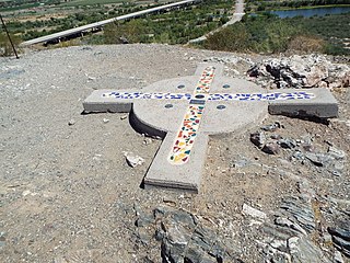
The Gila and Salt River Meridian intersects the initial point on the south side of the Gila River, opposite the mouth of Salt River, at latitude 33° 22′ 37.82733″ north, longitude 112° 18′ 21.99931″ west from Greenwich based on NAD 83, and governs the surveys in the territory of Arizona. The current declination for the initial point is 12° east. It is located on Monument Hill, an easily visible hill just south of the confluence of the Gila and Salt Rivers, in Avondale, Arizona, about 14 miles southwest of downtown Phoenix. The original marker was set in 1851 by John R. Bartlett. In 1934, the U.S. Coast and Geodetic Survey set triangulation station "INITIAL" approximately 15 feet from the initial point. Ty White, Associate Cadastral Engineer for the U.S. Bureau of Land Management (BLM), re-monumented the initial point on December 1, 1944. On April 24,1962, the monument was re-established by Leonard W. Murphy, based on the Ty White's field notes, because the previous monument had been vandalized. On April 26, 1984, Paul L. Reeves and John P. Bennet re-monumented the original corner. On February 19, 2006, the initial point was again re-monumented due to deterioration of the 1985 plaque. This re-monumentation was performed by staff from the BLM, members of the Arizona Professional Surveyors Society, and students at Phoenix College. The initial point was added to the National Register of Historic Places as of October 15, 2002. The plaque for that listing was installed as part of the 2006 re-monumenting.
The term fundamental station is used for special observatories which combine several space positioning techniques like VLBI, satellite laser ranging, GPS, Glonass, etc. They are the basis of plate tectonic analysis, allowing the monitoring of continental drift rates with millimetre accuracies. A fundamental point is the geometric origin of a geodetic network and defines the geodetic datum of a national survey.
A Discrete Global Grid (DGG) is a mosaic which covers the entire Earth's surface. Mathematically it is a space partitioning: it consists of a set of non-empty regions that form a partition of the Earth's surface. In a usual grid-modeling strategy, to simplify position calculations, each region is represented by a point, abstracting the grid as a set of region-points. Each region or region-point in the grid is called a cell.
