
The current population of Nepal is 29,164,578 as per the 2021 census. The population growth rate is 0.92% per year.

Nepal, officially the Federal Democratic Republic of Nepal, is a landlocked country in South Asia. It is mainly situated in the Himalayas, but also includes parts of the Indo-Gangetic Plain. It borders the Tibet Autonomous Region of China to the north, and India to the south, east, and west, while it is narrowly separated from Bangladesh by the Siliguri Corridor, and from Bhutan by the Indian state of Sikkim. Nepal has a diverse geography, including fertile plains, subalpine forested hills, and eight of the world's ten tallest mountains, including Mount Everest, the highest point on Earth. Kathmandu is the nation's capital and the largest city. Nepal is a multi-ethnic, multi-lingual, multi-religious and multi-cultural state, with Nepali as the official language.

Buddhism in Nepal started spreading since the reign of Ashoka through Indian and Tibetan missionaries. The Kiratas were the first people in Nepal who embraced the Buddha’s teachings, followed by the Licchavis and Newar people. Buddhism is Nepal's second-largest religion, with 8.2% of the country's population, or approximately 2.4 million people, identifying as adherents of Buddhism in a 2021 census.

Chhetri, historically called Kshettriya or Kshetriya or Khas are Nepali speaking Rajputs of Khas community, some of whom trace their origin to migration from medieval India. Chhetri was a caste of administrators, governor and military elites in the medieval Khas Kingdom and Gorkha Kingdom. The nobility of the Gorkha Kingdom mainly originated from Chhetri families. They also had a strong presence in civil administration affairs. The bulk of prime ministers of Nepal before the democratization of Nepal belonged to this caste as a result of the old Gorkhali aristocracy. Gorkha-based aristocratic Chhetri families included the Pande dynasty, the Basnyat dynasty, the Kunwar family, and the Thapa dynasty,.

Jhapa District is a district of Koshi Province in eastern Nepal named after a Rajbanshi Surjapuri language word "Jhapa", meaning "to cover" (verb). The 2021 Nepal Census, puts the total population of the district at 994,090. The total area of the district is 1,606 square kilometres.
Kailali District, a part of Sudurpashchim Province in Terai plain, is one of the 77 districts of Nepal. The district, with Dhangadhi as its district headquarters, covers an area of 3,235 square kilometres (1,249 sq mi) and has a population of 911,155 and, .
Islam is the third largest religion in Nepal. According to the 2021 Nepal census, approximately 1.483 million Muslims, comprising 5.09% of the population, live in Nepal.

Ethnic groups in Nepal are delineated using language, ethnic identity or the caste system in Nepal. They are categorized by common culture and endogamy. Endogamy carves out ethnic groups in Nepal.
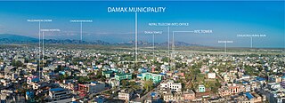
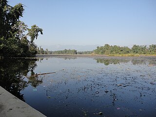
Damak, a city in eastern Nepal, is one of the oldest municipalities in Jhapa District in Koshi Province in eastern Nepal. It is situated between the Ratuwa River in the east and the Maawa River in the west. It has Sivalik Hills in its north and ends with the intersection of Ratuwa River and Maawa River in the south. Mahendra Highway, the longest highway of Nepal, bisects the municipality. It is the largest city in Jhapa District with a population of 107,410 in 2021.

Nepali are the citizens of Nepal under Nepali nationality law. The term Nepali usually refers to the nationality, that is, to people with citizenship of Nepal, while the people without Nepalese citizenship but with roots in Nepal such as Nepalese Americans and Indian Gorkhas are strictly referred to as Nepali Speaking Foreigners who are speakers of Nepali, Maithili or any of the other 128 Nepali languages but are now foreign citizens or of foreign nationality bearing passports and citizenship of the foreign nation. It is also not generally used to refer to non-citizen residents, dual citizens, and expatriates.

Languages of Nepal, referred to as Nepalese languages in the country's constitution, are the languages having at least an ancient history or origin inside the sovereign territory of Nepal spoken by Nepalis.

A village development committee in Nepal was the lower administrative part of its Ministry of Federal Affairs and Local Development. Each district had several VDCs, similar to municipalities but with greater public-government interaction and administration. There were 3,157 village development committees in Nepal. Each village development committee was further divided into several wards depending on the population of the district, the average being nine wards.
The 1991 Nepal census was a widespread national census conducted by the Nepal Central Bureau of Statistics.

The Tharu or Tharuhat languages are any of the Indo-Aryan languages spoken by the Tharu people of the Terai region in Nepal, and neighboring regions of Uttarakhand, Uttar Pradesh and Bihar in India.
Shivanagar is a town in Krishnanagar Municipality in Kapilvastu District in the Lumbini Zone of southern Nepal. The former VDC was merged to form the municipality established on 18 May 2014 Krishnanagar, Sirsihawa, Shivanagar VDCs. At the time of the 2011 Nepal census it had a population of 4,774 people living in 735 individual households.
Nepal Canadians or Nepali Canadians are Canadians with roots in Nepal.
Nepal conducted a widespread national census in 2011 by the Nepal Central Bureau of Statistics. Working with the 58 municipalities and the 3,915 Village Development Committees at a district level, they recorded data from all the municipalities and villages of each district. The data included statistics on population size, households, sex and age distribution, place of birth, residence characteristics, literacy, marital status, religion, language spoken, caste/ethnic group, economically active population, education, number of children, employment status, and occupation.
The 2001 Nepal census was conducted by the Nepal Central Bureau of Statistics. According to the census, the population of Nepal in 2001 was 23,151,423. Working with Nepal's Village Development Committees at a district level, they recorded data from all the main towns and villages of each district of Nepal. The data included statistics on population size, households, sex and age distribution, place of birth, residence characteristics, literacy, marital status, religion, language spoken, caste/ethnic group, economically active population, education, number of children, employment status, and occupation.

Nepali is an Indo-Aryan language native to the Himalayas region of South Asia. It is the official, and most widely spoken, language of Nepal, where it also serves as a lingua franca. Nepali has official status in the Indian state of Sikkim and in the Gorkhaland Territorial Administration of West Bengal. It is spoken by about a quarter of Bhutan's population. Nepali also has a significant number of speakers in the states of Arunachal Pradesh, Assam, Himachal Pradesh, Manipur, Meghalaya, Mizoram and Uttarakhand. In Myanmar it is spoken by the Burmese Gurkhas. The Nepali diaspora in the Middle East, Brunei, Australia and worldwide also use the language. Nepali is spoken by approximately 19 million native speakers and another 14 million as a second language.
Sundar Haraicha is a municipality in Morang District of Koshi Province in Nepal. It is centered around Biratchowk town which is the gateway to Biratnagar. It borders Itahari Sub- Metropolitan city to the west, Dharan Sub- Metropolitan city to the Northwest and Belbari municipality to the east and is connected by Mahendra Highway. It is one of the fastest growing cities in eastern Nepal and the second largest city of Morang district after Biratnagar, with 121,305 inhabitants living in 26,677 households. It consists of the town centres of Biratchowk and Gothgaun which are parts of the Greater Birat Development Area which incorporates the cities of Biratnagar-Itahari-Gothgau-Biratchowk-Dharan primarily located on the Koshi Highway in Eastern Nepal, with an estimated total urban agglomerated population of 804,300 people living in 159,332 households.

