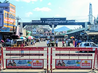
Puduvayal is a town in Karaikudi taluk, Sivaganga district in the Indian state of Tamil Nadu. It is a town located in the Chettinad region of the Sivagangai district. On road, it is 12 km away from Karaikudi and 21 km away from Aranthangi. This town is famous for its rice mills. Puduvayal is the 2nd largest rice producer in Tamil Nadu. Puduvayal is an important commercial centre for trade in the Sivaganga district and part of the suburban region of Karaikudi. The town is famous for its Veerasekara Umaiyambigai Temple. Nearby Kandanur is famous for Kandanur Sivan Kovil—which is a replica of the Madurai Meenakshi Temple—built by Nagarthars.
Andipatti is a Panchayat town in Theni district, Madurai Region, At the state of Tamil Nadu, India.
Elumalai is a Panchayat town in the district of Madurai, in the Indian state of Tamil Nadu. Originally named Aezhumalai, the town is located near Usilampatti (18 km), Madurai (58 km), Theni (56 km), Peraiyur (24 km) and Tirumangalam (40 km) in the Western ghats.
Iglas is a town and tehsil in Aligarh district in the Indian state of Uttar Pradesh.
Madathukulam is Border to Dindigul District in Tirupur district in the Indian state of Tamil Nadu.
Mulanur is a panchayat town under in Dharapuram taluk in Tirupur District in the Indian state of Tamil Nadu.
Othakadai is a panchayat town in Madurai district in the Indian state of Tamil Nadu.

Palani Chettipatti is a panchayat grama in Theni district in the Indian state of Tamil Nadu. It is located on the road between Theni and Cumbum. The Mullai river flows via this village from Uthamapalayam and goes down the valley pin code is 625531.
Peraiyur is a panchayat town in Madurai district in the Indian state of Tamil Nadu. It is one of the Revenue blocks of Madurai District. Peraiyur is the headquarters of the peraiyur taluk.
Thiruvaikuntam (திருவைகுண்டம்), also referred to as Srivaikuntam is a panchayat town in Thoothukudi district in the Indian state of Tamil Nadu. It is located on the banks of the river Thamirabarani.
Sundarapandiam is a panchayat town in Watrap taluk, Virudhunagar district in the Indian state of Tamil Nadu.
Thirunagar is a neighborhood within the Madurai district in the Indian state of Tamil Nadu.

Usilampatti is a town and a second grade municipality in the Indian state of Tamil Nadu. It is also a designated taluk and revenue division.
T. Vadipatti is a panchayat town in the Madurai district in the Indian state of Tamil Nadu.and also known as "west gateway of Madurai.
Vasudevanallur is a town panchayat located 37 km from Tenkasi District in the Indian state of Tamil Nadu. It is located under the Western Ghats
Vedasanthoor is a panchayat town in Dindigul district Located at Indian state of Tamil Nadu. Vedasanthoor town is 21 km (13 mi) from Dindigul city, 25 km (16 mi) from Oddanchatram town, and 82 km (51 mi) from Madurai.

Thiruppuvanam is a town in Manamadurai Constituency and also Manamadurai division in the Indian state of Tamil Nadu.
Eriyodu is a panchayat town located in Dindigul district of Madurai Region in the state of Tamil Nadu, India. It is a part of vedasandur legislative constituency and karur parliamentary constituency. Eriyodu is in the administrative district of Dindigul. Eriyodu is located in Dindigul next to Karur State Highway road.
Sukkangalpatti is a panchayat town in Theni district in the Indian state of Tamil Nadu.

Tiruppattur, also spelt Tiruppathur or Thiruppathur, is a Taluk, Town Panchayat in Sivaganga district in the India state of Tamil Nadu. It is in Sivaganga district, 27 km from Sivaganga and 22 km from Karaikudi. It is famous for Thiruthalinathar Temple, a Padal petra sthaalam, the sixth of 14 in the Pandyan region.


