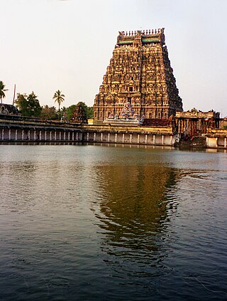
Chidambaram is a town and municipality in Cuddalore district in the Indian state of Tamil Nadu, on the banks of the Vellar River where it meets the Bay of Bengal. It is the headquarters of the Chidambaram taluk. The town is believed to be of significant antiquity and has been ruled, at different times, by the Pallavas until ninth century, Medieval Cholas, Later Cholas, Later Pandyas, Vijayanagara Empire, Thanjavur Nayakas, Marathas and the British. The town is known for the Thillai Nataraja Temple and Thillai Kali Temple, and the annual chariot festival held in the months of December–January and June to July. One of the Divya Desams Divya Sri Govindaraja Perumal Temple (Thiruchitrakoodam) is a part of Thillai Nataraja Temple complex. Thiruvetkalam Shiva Temple, Vadakiruppu, Thirunelvayil Shiva Temple, Sivapuri and Tirukkazhippalai Palvannanathar Temple are the other three ancient Shiva temples in the region.

Perambalur is one of the 38 districts in the state of Tamil Nadu, India. The district headquarters is located at Perambalur. The district occupies an area of 1,752 km2 and had a population of 565,223 with a sex-ratio of 1,003 females for every 1,000 males in 2011.
Panruti is a developing city, municipality and taluk headquarters of Cuddalore district, Tamil Nadu, India. Panruti is located between Cuddalore and Neyveli. Panruti is famous for jackfruits and cashew nuts. The jackfruit grown here is exported worldwide and is very sweet. It is a business capital of Cuddalore district. Kananchavadi one of the villages in panruti taluk, famous for palm juice. It has been a great commercial area for more than 200 years. The name Panruti came from the Tamil words "Pann" and "Urutti" meaning "composing song and music", as the place is where many saints and great religious singers such as nayanmars and vainavas sung. A 150-year-old government school was built here by the British East India Company and a more-than-1000-year-old temple Veerattaneswarar temple is nearby in Thiruvathigai. As of 2011, the town had a population of 60,323.
Devakottai is a first-grade municipality in the state of Tamil Nadu, India. Located in the Sivaganga district, the town is situated close to the Karaikudi, near Rameswaram National Highway Road (NH-210). It is one of the major cities comes under the Chettinad area with rich heritage of houses built with limestone called "Karai Veedu". This Region is one of the towns in Chettinad belt. The town is famous for its ancient temple Sri Meenakshi Sundareswarar temple also known as Nagara Sivan Kovil.

Vellore district is one of the 38 districts in the Tamil Nadu state of India. It is one of the eleven districts that form the north region of Tamil Nadu. Vellore city is the headquarters of this district. As of 2011, the district had a population of 1,614,242 with a sex ratio of 1,007 females for every 1,000 males. In 2017 Vellore district ranked eleventh in list of districts in Tamil Nadu by Human Development Index.
Puzhuthivakkam, commonly known as Ullagaram or Ullagaram–Puzhuthivakkam, is a southern neighbourhood of Chennai in Tamil Nadu, India. Puzhuthivakkam loosely translates to dust neighborhood. The neighbourhood is part of the Greater Chennai Corporation, following Chennai's expansion into Kanchipuram district. Puzhuthivakkam is located between the neighborhoods of Madipakkam, Adambakkam, Velachery, Pallikaranai, and Nanganallur. Puzhuthivakkam was initially developed in the late 1960s and early 1970s. Upon completion of the MRTS extension line, the neighborhood will be served by Puzhuthivakkam railway station. As of 2011, the town had a population of 53,322.

Cuddalore District is one of the 38 districts in the state of Tamil Nadu in India.
Ambasamudram is the principal town of the Ambasamudram taluk in Tirunelveli district in the state of Tamil Nadu, India. The entire taluk had a population of 392,226 as of 2001, with 42.5% classified as rural. The town of Ambasamudram had a population 35,645 as of 2011.
Anakaputhur is a neighbourhood in Tambaram, which is part of the Chennai Metropolitan Area in the Indian state of Tamil Nadu. It is located next to Pammal on the western side. Anakaputhur was once famous for its traditional weaving business, which has declined due to modern competition. As of 2011, the town had a population of 48,050.

Bodinayakanur is a Town and a municipality in Theni district in the state of Tamil Nadu, India.
Edappadi is a municipality in the Salem district in the state of Tamil Nadu, India. Edappadi was once known for its thriving power loom industry. The economy is diversified by agriculture, heavy truck transport, granite, entertainment and foundries.

Jayankondam is a First Grade Municipality in Ariyalur district of Tamil Nadu in India. As of 2022, the town had a population of 45,000.

Kattumannarkoil is a panchayat town and taluk headquarters in Cuddalore district in the Indian state of Tamil Nadu. Kattumannarkoil Town Panchayat constituted in 1892. The town is coming under the administrative territory of Cuddalore District. The town extends over an area of 19.425 km2. The town is situated along 25 km South West of Chidambaram and lies on the Chidambaram - Coimbatore Highway and 25 km East of Srimushnam and a similar distance north-east of Gangaikonda Cholapuram. The Place is considered as the birth place of one of the great Vaishnavate Acharya Nathamuni and Yamunacharya. As Lord Vishnu came here as King ‘Mannan’ to hold the hand of Mahalakshmi; and later asked Nathamunigal to share the Divya Prabandham and the Vaishnava Sampradayam to the world at large, he was referred to as ‘ Kattum – Mannan – Aanaar’ and the town later became Kattu Mannar. The place historic name was Veeranarayanapuram.
Lalpet is a Panchayat town in Cuddalore district, Tamil Nadu. Lalpet is situated in lush green surrounding with water bodies. Lalpet was named after Lal Khan who held an administrative position under the ruling Prince Nawab of Arcot. Under the command of the prince, Lal Khan developed this town in 1775 for Arab traders, Muslims, international visitors and people of other faiths to dwell together peacefully. Arabic college named "Jamia Manba'ul Anwar" was established here in 1862. Lalpet was established before in 1775 by Lal Khan. Lalpet is a commune. Lalpet Commune consists of one census town and 8 panchayat villages. The town extends over an area of 16.425 km2.

Madurantakam is the southernmost suburb of Chennai city and a municipality in Chengalpattu district in the Indian state of Tamil Nadu. The town is known for the artificial and second largest lake in Tamil Nadu, the Maduranthakam lake. It is said to have been built by the Chola King Uttama Chola, also called as Maduranthaka, during his reign. It is also home to the Eri-Katha Ramar Temple. As of 2011, the town had a population of 30,796.
Nellikuppam is a town and a municipality in Cuddalore city Corporation in the Indian state of Tamil Nadu. As of 2011, the town had a population of 46,678.
Tindivanam is a town and a municipality in Viluppuram district in the Indian state of Tamil Nadu. It is the second largest town in Villupuram District after the headquarters town Villupuram. Important roads from north to south Tamil Nadu pass through Tindivanam and similarly from west to east.
Valasaravakkam is a neighbourhood in the Chennai district of the Indian state of Tamil Nadu and a residential suburb of the city of Chennai. It is located in the Poonamallee Taluk at a distance of approximately 15 kilometres from the Kilometer Zero stone. Valasaravakkam lies on the Arcot Road, one of Chennai's arterial roads. It is under the Maduravoyal election constituency. In October, 2011 Valasaravakkam Municipality ceased to exist and the area became part of Chennai Corporation as Ward Nos 149 and 152, Southern Region, Corporation of Chennai. As of 2011, the town had a population of 47,378. Famous Sivan temple is in Kesavardhini.

Virudhachalam or Vriddhachalam is a Town and taluk headquarters in Cuddalore district in the Indian state of Tamil Nadu. The ancient name of this town is Thirumudhukundram. As per the 2011 census, the town had a population of 73,585 of which 37,066 are males while 36,519 are females. Population of children in the ages of 0-6 is 7735 which is 10.51 % of the total population. The old Lord Siva temple is located in the heart of town. This is the 41st Devaram Padal Petra Siva Thiruthalam and 9th Thiruthalam in Nadu Naadu(நடுனாடு). Moovar has sung hymns in praise of Lord Siva of this temple. The temple was constructed by one of the Chola Emperors. The famous Kolanjiappar Temple is located 3 km away from the town. Both of them are situated near Cuddalore - Salem highway in Virudhachalam.
Vadakkumangudi is a village in Kattumannarkoil taluk, Cuddalore District, in India. It is situated in between Sirkazhi and Chidambaram and 16 km from KattumannarkoilAccording to Census 2011 information the location code or village code of Vadakkumangudi village is 636977. Vadakkumangudi village is located in Kattumannarkoil taluka of Cuddalore district in Tamil Nadu, India. It is situated 30km away from sub-district headquarter Kattumannarkoil and 55km away from district headquarter Cuddalore. As per 2009 stats, Vadakkumangudi village is also a gram panchayat.

