Related Research Articles

Thurston Island is a largely ice-covered, glacially dissected island, 135 nautical miles long and 55 nautical miles wide, lying between Amundsen Sea and Bellingshausen Sea a short way off the northwest end of Ellsworth Land, Antarctica. The island is separated from the mainland by Peacock Sound, which is occupied by the west portion of Abbot Ice Shelf.
The Wisconsin Range is a major mountain range of the Horlick Mountains in Antarctica, comprising the Wisconsin Plateau and numerous glaciers, ridges and peaks bounded by the Reedy Glacier, Shimizu Ice Stream, Horlick Ice Stream and the interior ice plateau.
Hope Bay is a bay 3 nautical miles long and 2 nautical miles wide, indenting the tip of the Antarctic Peninsula and opening on Antarctic Sound.
The Deep Freeze Range is a rugged mountain range, over 80 nautical miles long and about 10 nautical miles wide, rising between Priestley and Campbell Glaciers in Victoria Land, Antarctica, and extending from the edge of the polar plateau to Terra Nova Bay. It is southwest of the Southern Cross Mountains, south of the Mesa Range and northeast of the Eisenhower Range of the Prince Albert Mountains.
Lillie Glacier is a large glacier in Antarctica, about 100 nautical miles long and 10 nautical miles wide. It lies between the Bowers Mountains on the west and the Concord Mountains and Anare Mountains on the east, flowing to Ob' Bay on the coast and forming the Lillie Glacier Tongue.
The Possession Islands are a group of small islands and rocks extending over an area of about 7 nautical miles, lying in the western part of the Ross Sea, lying 5 nautical miles south-east of Cape McCormick, in Victoria Land, Antarctica. The Possession Islands were named by Captain James Clark Ross, Royal Navy, in commemoration of the planting of the British flag here on January 12, 1841.

The Prince Charles Mountains are a major group of mountains in Mac. Robertson Land in Antarctica, including the Athos Range, the Porthos Range, and the Aramis Range. The highest peak is Mount Menzies, with a height of 3,228 m (10,591 ft). Other prominent peaks are Mount Izabelle and Mount Stinear. These mountains, together with other scattered peaks, form an arc about 420 km (260 mi) long, extending from the vicinity of Mount Starlight in the north to Goodspeed Nunataks in the south.

The Quartermain Mountains are a group of exposed mountains in Antarctica, about 20 nautical miles long, typical of ice-free features of the McMurdo Dry Valleys, Victoria Land. They are east of the Lashly Mountains, south of the Asgard Range, west of the Kukri Hills and Royal Society Range, and some distance north of the Worcester Range.

The Outback Nunataks are a series of bare rock nunataks and mountains which are distributed over an area about 40 nautical miles long by 20 nautical miles wide. The group lies south of Emlen Peaks of the Usarp Mountains and west of Monument Nunataks and upper Rennick Glacier, adjacent to the featureless interior plateau.
Mount Bird is a 1,765 metres (5,791 ft) high shield volcano standing about 7 nautical miles south of Cape Bird, the northern extremity of Ross Island. It was mapped by the British National Antarctic Expedition, 1901–04, under Robert Falcon Scott, and apparently named by them after Cape Bird.
Southern Cross Mountains is the name applied to the group of ranges lying between the Mariner Glacier and Priestley Glacier in Victoria Land, Antarctica. It is southwest of the Mountaineer Range, southeast of the Mesa Range and northeast of the Deep Freeze Range.
The Mountaineer Range is the range of mountains lying between the Mariner Glacier and Aviator Glacier in Victoria Land, Antarctica. It lies to the south of the Victory Mountains and northeast of the Southern Cross Mountains.
The Doggers Nunataks are a group of peaks 30 nautical miles (60 km) southwest of Rayner Peak, to the southwest of Edward VIII Bay. They were photographed in October 1956 by Australian National Antarctic Research Expeditions (ANARE) aircraft and surveyed in December 1958 by G.A. Knuckey during a dog-sledge journey from Amundsen Bay to Mawson Station. The group was named by the Antarctic Names Committee of Australia for the members of the 1958 ANARE dog sledging party who were always referred to as the "Doggers."
The Latady Mountains are a group of mountains rising west of Gardner Inlet and between Wetmore Glacier and Ketchum Glacier, in southeastern Palmer Land, Antarctica.
Mount Oydeholmen, also Mount Kernot is a mostly ice-covered mountain standing 4 nautical miles (7 km) west of Rayner Peak, southward of Edward VIII Bay in Enderby Land. It was mapped by Norwegian cartographers from air photos taken by the Lars Christensen Expedition of 1936–37 and was named Oydeholmen. The name means "the desolate island" in Norwegian.
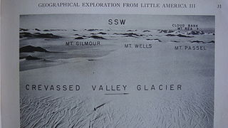
The Denfeld Mountains are a group of scattered mountains between Crevasse Valley Glacier and Arthur Glacier in the Ford Ranges of Marie Byrd Land, Antarctica.
Edward Ridge is a gently rising, snow-covered ridge standing 13 nautical miles (24 km) northwest of Rayner Peak in Enderby Land, Antarctica. It was plotted from air photos taken from Australian National Antarctic Research Expeditions (ANARE) aircraft in 1959, and was named by the Antarctic Names Committee of Australia for Edward Nash, an aircraft mechanic with ANARE, under Phillip Law in 1965.
The Marshall Mountains are a group of mountains overlooking Beardmore Glacier in the Queen Alexandra Range, Antarctica. They are bounded on the north by Berwick Glacier, and on the south by Swinford Glacier.
Hobbs Ridge is a prominent arc-shaped ridge which circumscribes Hobbs Glacier to the north and northwest and forms the divide with the lower part of Blue Glacier, on the Scott Coast of Victoria Land, Antarctica. It was named in association with Hobbs Glacier. It forms the northernmost part of the Denton Hills.

Mackay Glacier is a large glacier in Victoria Land, descending eastward from the Antarctic Plateau, between the Convoy Range and Clare Range, into the southern part of Granite Harbour. It was discovered by the South magnetic pole party of the British Antarctic Expedition, 1907–09, and named for Alistair Mackay, a member of the party. The glacier's tongue is called Mackay Glacier Tongue. First mapped by the British Antarctic Expedition, 1910–13 and named for Alistair F. Mackay, a member of the party. Its mouth is south of the Evans Piedmont Glacier and the Mawson Glacier. It is north of the Wilson Piedmont Glacier and the Ferrar Glacier.
References
![]() This article incorporates public domain material from "Rayner Peak". Geographic Names Information System . United States Geological Survey.
This article incorporates public domain material from "Rayner Peak". Geographic Names Information System . United States Geological Survey.
| | This Enderby Land location article is a stub. You can help Wikipedia by expanding it. |