Related Research Articles
A personal digital assistant (PDA), also known as a handheld PC, is a variety mobile device which functions as a personal information manager. PDAs have been mostly displaced by the widespread adoption of highly capable smartphones, in particular those based on iOS and Android.
Wireless communication is the transfer of information between two or more points that do not use an electrical conductor as a medium by which to perform the transfer. The most common wireless technologies use radio waves. With radio waves, intended distances can be short, such as a few meters for Bluetooth or as far as millions of kilometers for deep-space radio communications. It encompasses various types of fixed, mobile, and portable applications, including two-way radios, cellular telephones, personal digital assistants (PDAs), and wireless networking. Other examples of applications of radio wireless technology include GPS units, garage door openers, wireless computer mouse, keyboards and headsets, headphones, radio receivers, satellite television, broadcast television and cordless telephones. Somewhat less common methods of achieving wireless communications include the use of other electromagnetic wireless technologies, such as light, magnetic, or electric fields or the use of sound.

Wardriving is the act of searching for Wi-Fi wireless networks, usually from a moving vehicle, using a laptop or smartphone. Software for wardriving is freely available on the internet.

A mobile device is a computer small enough to hold and operate in the hand. Typically, any handheld computer device will have an LCD or OLED flatscreen interface, providing a touchscreen interface with digital buttons and keyboard or physical buttons along with a physical keyboard. Many such devices can connect to the Internet and interconnect with other devices such as car entertainment systems or headsets via Wi-Fi, Bluetooth, cellular networks or near field communication (NFC). Integrated cameras, the ability to place and receive voice and video telephone calls, video games, and Global Positioning System (GPS) capabilities are common. Power is typically provided by a lithium-ion battery. Mobile devices may run mobile operating systems that allow third-party apps specialized for said capabilities to be installed and run.

A geotagged photograph is a photograph which is associated with a geographic position by geotagging. Usually this is done by assigning at least a latitude and longitude to the image, and optionally altitude, compass bearing and other fields may also be included.
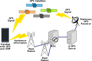
Assisted GNSS (A-GNSS) is a GNSS augmentation system that often significantly improves the startup performance—i.e., time-to-first-fix (TTFF)—of a global navigation satellite system (GNSS). A-GNSS works by providing the necessary data to the device via a radio network instead of the slow satellite link, essentially "warming up" the receiver for a fix. When applied to GPS, it is known as assisted GPS or augmented GPS. Other local names include A-GANSS for Galileo and A-Beidou for BeiDou.

Mobile phone tracking is a process for identifying the location of a mobile phone, whether stationary or moving. Localization may be effected by a number of technologies, such as using multilateration of radio signals between (several) cell towers of the network and the phone, or simply using GPS. To locate a mobile phone using multilateration of mobile radio signals, it must emit at least the idle signal to contact nearby antenna towers, but the process does not require an active call. The Global System for Mobile Communications (GSM) is based on the phone's signal strength to nearby antenna masts.
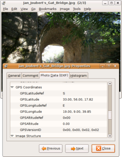
Geotagging, or GeoTagging, is the process of adding geographical identification metadata to various media such as a geotagged photograph or video, websites, SMS messages, QR Codes or RSS feeds and is a form of geospatial metadata. This data usually consists of latitude and longitude coordinates, though they can also include altitude, bearing, distance, accuracy data, and place names, and perhaps a time stamp.

The BlackBerry Pearl was a series of smartphones developed by Research In Motion, and was the first BlackBerry device with a camera and media player. It was originally released on September 12, 2006. T-Mobile was the first US carrier to release the phone as a carrier device. The last BlackBerry Pearl released was the 9100 series on May 13, 2010. After this model was cleared out, RIM discontinued the Pearl series.
Global Navigation Satellite System (GNSS) receivers, using the GPS, GLONASS, Galileo or BeiDou system, are used in many applications. The first systems were developed in the 20th century, mainly to help military personnel find their way, but location awareness soon found many civilian applications.

The HTC TyTN II is an Internet-enabled Windows Mobile Pocket PC smartphone designed and marketed by HTC Corporation of Taiwan. It has a tilting touchscreen with a right-side slide-out QWERTY keyboard. The TyTN II's functions include those of a camera phone and a portable media player in addition to text messaging and multimedia messaging. It also offers Internet services including e-mail, instant messaging, web browsing, and local Wi-Fi connectivity. It is a quad-band GSM phone with GPRS, EDGE, UMTS, HSDPA, and HSUPA.
An indoor positioning system (IPS) is a network of devices used to locate people or objects where GPS and other satellite technologies lack precision or fail entirely, such as inside multistory buildings, airports, alleys, parking garages, and underground locations.
Wi-Fi positioning system is a geolocation system that uses the characteristics of nearby Wi-Fi hotspots and other wireless access points to discover where a device is located. It is used where satellite navigation such as GPS is inadequate due to various causes including multipath and signal blockage indoors, or where acquiring a satellite fix would take too long. Such systems include assisted GPS, urban positioning services through hotspot databases, and indoor positioning systems. Wi-Fi positioning takes advantage of the rapid growth in the early 21st century of wireless access points in urban areas.
Social photography is a subcategory of photography focusing upon the technology, interaction and activities of individuals who take photographs. Digital cameras, photo sharing websites and the Internet have enabled new tools and methods of social networking while consumer trends such as flashpacking and adventure travel have led to a worldwide increase in socially connected photographers.
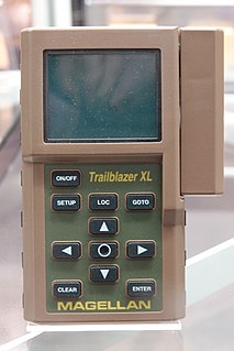
A satellite navigation device, colloquially called a GPS receiver, or simply a GPS, is a device that is capable of receiving information from GNSS satellites and then calculate the device's geographical position. Using suitable software, the device may display the position on a map, and it may offer routing directions. The Global Positioning System (GPS) is one of a handful of global navigation satellite systems (GNSS) made up of a network of a minimum of 24, but currently 30, satellites placed into orbit by the U.S. Department of Defense.

Navizon, Inc. is a provider of location-based services and products. Navizon was an early developer of technology that makes it possible to determine the geographic position of a mobile device using as reference the location of cell phone towers and Wi-Fi-based wireless access points instead of GPS. Navizon also developed technology for locating mobile devices indoors with room and floor-level accuracy.
The Ricoh 500SE digital compact camera is suitable for outdoor photography and networkability. Capability includes external information such as GPS position or barcode numbers within the image headers. External vendors sell hardware and software for workflows involving GPS positioning or barcode scanning. Most NMEA compliant bluetooth GPS receivers can be used with this camera through its built in bluetooth communication capability. The body is resistant to dust and water, making it robust for many environments.

Samsung GT-i8910 Omnia HD is a smartphone manufactured by Samsung Electronics, first announced at MWC 2009 on February 18, 2009. The device was the first phone capable of playing and recording 720p HD video. It runs on the S60 5th Edition (Symbian^1) platform, the only Samsung device to do so.
Mobile technology is the technology used for cellular communication. Mobile technology has evolved rapidly over the past few years. Since the start of this millennium, a standard mobile device has gone from being no more than a simple two-way pager to being a mobile phone, GPS navigation device, an embedded web browser and instant messaging client, and a handheld gaming console. Many experts believe that the future of computer technology rests in mobile computing with wireless networking. Mobile computing by way of tablet computers is becoming more popular. Tablets are available on the 3G and 4G networks. Mobile technology has different meanings in different aspects, mainly mobile technology in information technology and mobile technology in basketball technology, mainly based on the wireless technology of wireless devices equipment information technology integration.
A mobile broadband modem is a type of modem that allows a personal computer or a router to receive Internet access via a mobile broadband connection instead of using telephone or cable television lines. A mobile Internet user can connect using a wireless modem to a wireless Internet Service Provider (ISP) to get Internet access.
References
- ↑ Shankland, Stephen (2008-02-12). "Cameras with built-in geotagging on horizon". cnet .
- ↑ "Google Earth surpasses 500 million". Google Earth Blog. 2009-08-04.
- ↑ Smartphone shipments Mobithinking.com
- ↑ Kevin J. O'Brien, New York Times, 2010 Nov 15 Smartphone Sales Taking Toll on G.P.S. Devices