
Red Bluff (colloquially known as Mississippi's Little Grand Canyon) is a natural geologic feature, located in Marion County, Mississippi, [1] located about 1.5 miles northwest of the community of Morgantown. [2]
Red Bluff (colloquially known as Mississippi's Little Grand Canyon) is a natural geologic feature, located in Marion County, Mississippi, [1] located about 1.5 miles northwest of the community of Morgantown. [2]
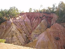
Red Bluff is a geological formation created by the natural erosion of the west bank of the Pearl River. The bluff is an exposure red clay, soil, sand, and other colorful sediments [3] and rises to an elevation of approximately 371 feet above sea level. [1] The bluff slopes sharply (200 feet) [3] into the Pearl River floodplain. [2] The natural erosion process continues and has forced the movement of nearby Mississippi Highway 587 at least two times. [3] [4]
The view from the bluff encompasses a significant portion of the Pearl River Basin in Marion County, as well as the eastern portion of the nearby city of Columbia, Mississippi. The land where the bluff is located is privately owned, so hiking is prohibited, but the bluff can be viewed from roadside parking areas along Mississippi Highway 587. [3] [5]
Pearl River County is a county located in the U.S. state of Mississippi. The population was 56,145 at the 2020 census. Its county seat is Poplarville.

Marion County is a county located in the U.S. state of Mississippi. As of the 2020 census, the population was 24,441. Its county seat is Columbia. Marion County is named for American Revolutionary War guerrilla leader Francis Marion also known as The Swamp Fox.

Lamar County is a county located in the U.S. state of Mississippi. As of the 2020 census, the population was 64,222. Its county seat is Purvis. Named for Confederate Lucius Quintus Cincinnatus Lamar, the county was carved out of Marion County to the west in 1904.

Hokah is a city in Houston County, Minnesota, United States. The population was 580 at the 2010 census. Hokah is located near the confluence of the Root and Mississippi rivers, opposite La Crosse, Wisconsin, and is part of the La Crosse metropolitan area.

Palo Duro Canyon is a canyon system of the Caprock Escarpment located in the Texas Panhandle near the cities of Amarillo and Canyon. As the second-largest canyon in the United States, it is roughly 120 mi (190 km) long and has an average width of 6 mi (9.7 km), but reaches a width of 20 mi (32 km) at places. Its depth is around 800 ft (240 m), but in some locations, it increases to 1,000 ft (300 m). Palo Duro Canyon has been named "The Grand Canyon of Texas" both for its size and for its dramatic geological features, including the multicolored layers of rock and steep mesa walls, which are similar to those in the Grand Canyon. It is part of Palo Duro Canyon State Park.
The exposed geology of the Bryce Canyon area in Utah shows a record of deposition that covers the last part of the Cretaceous Period and the first half of the Cenozoic era in that part of North America. The ancient depositional environment of the region around what is now Bryce Canyon National Park varied from the warm shallow sea in which the Dakota Sandstone and the Tropic Shale were deposited to the cool streams and lakes that contributed sediment to the colorful Claron Formation that dominates the park's amphitheaters.

The Allegheny Front is the major southeast- or east-facing escarpment in the Allegheny Mountains in southern Pennsylvania, western Maryland, eastern West Virginia, and western Virginia, USA. The Allegheny Front forms the boundary between the Ridge-and-Valley Appalachians to its east and the Appalachian Plateau to its west. The Front is closely associated with the Appalachian Mountains' Eastern Continental Divide, which in this area divides the waters of the Ohio/Mississippi river system, flowing to the Gulf of Mexico, from rivers flowing into Chesapeake Bay and from there into the Atlantic Ocean.

The Driftless Area, also known as Bluff Country, the Blufflands, the Paleozoic Plateau, and the Coulee Region, is a topographical and cultural region in the Midwestern United States that comprises southwestern Wisconsin, southeastern Minnesota, northeastern Iowa, and the extreme northwestern corner of Illinois. The Driftless Area is a USDA Level III Ecoregion: Ecoregion 52. The Driftless Area takes up a large portion of the Upper Midwest forest–savanna transition.

Great River Bluffs State Park is a state park of Minnesota, United States, on the Mississippi River southeast of Winona. Originally known as O. L. Kipp State Park, it was renamed in the late 1990s to describe better its resources. The park preserves steep-sided bluffs rising 500 feet (150 m) above the river and the narrow valleys between them, which support rare and fragile plant communities. Two of the bluffs have received further protection under the Minnesota Scientific and Natural Areas program, which are known as King's and Queen's Bluff Scientific and Natural Area.

Horseshoe Bend is a horseshoe-shaped incised meander of the Colorado River located near the town of Page, Arizona, United States. It is also referred to as the "east rim of the Grand Canyon."

The Loess Hills are a formation of wind-deposited loess soil in the westernmost parts of Iowa and Missouri, and the easternmost parts of Nebraska and Kansas, along the Missouri River.

Providence Canyon State Outdoor Recreation Area is a 1,003-acre (405.90 ha) Georgia state park located in Stewart County in southwest Georgia, United States. The park contains Providence Canyon, which is sometimes called Georgia's "Little Grand Canyon". It is considered one of the Seven Natural Wonders of Georgia. It is also home to the very rare plumleaf azalea.
Paint Creek is a direct tributary of the Upper Mississippi River, rising in central Allamakee County, Iowa, in and about the city of Waukon. The catchment measures approximately 85.5 square miles (221 km2). It has some still-rural stretches past 9th Street Southwest in Waukon, but most of the actual Waukon portions have been culverted. It joins the Mississippi approximately 6 miles (9.7 km) above Marquette, Iowa in Pool 10, near river mile 641.
Apple River Canyon State Park is an Illinois state park on 297 acres (120 ha) in Jo Daviess County, Illinois, United States. The park was begun with land purchased by the state in 1932, as a result of a prolonged campaign led by botanist Herman Silas Pepoon; with additional acquisitions since, 1,907 acres (772 ha) of land have been preserved to protect much of an 8+1⁄2-mile (13.7 km) long canyon on the Apple River.

Randolph is a rural unincorporated community in Tipton County, Tennessee, United States, located on the banks of the Mississippi River. Randolph was founded in the 1820s and in 1827, the Randolph post office was established. In the 1830s, the town became an early center of river commerce in West Tennessee. Randolph shipped more cotton annually than Memphis until 1840. In 1834, the first pastor of the Methodist congregation was appointed. The fortunes of the community began to decline in the late 1840s due to failed railroad development, an unfavorable mail route and other factors. The first Confederate States Army fort in Tennessee was built at Randolph early in the Civil War in 1861, a second fortification at Randolph was constructed later that same year. During the Civil War, the town was burned down twice by Union Army forces.
Morgantown is an unincorporated community located on Mississippi Highway 587 in northwest Marion County, Mississippi, United States.

The Trail of the Ancients is a collection of National Scenic Byways located in the U.S. Four Corners states of Utah, Colorado, New Mexico, and Arizona. These byways comprise:
Ball Bluff is an unincorporated community in Ball Bluff Township, Aitkin County, Minnesota, United States. The community is located between Jacobson and McGregor along State Highway 65. The Mississippi River flows nearby.

Red Creek is a tributary of the Pascagoula River in the U.S. state of Mississippi. The creek derives its name from naturally occurring tannins that give the water a reddish appearance as it flows over the white sand bottom. A portion of Red Creek has been designated a State Scenic Stream by the Mississippi Legislature.

Mississippi Highway 44 (MS 44) is a 48.6-mile-long (78.2 km) disconnected state highway comprising three segments in south-central Mississippi.