
Sundarbans is a mangrove area in the delta formed by the confluence of the Ganges, Brahmaputra and Meghna Rivers in the Bay of Bengal. Spread across parts of India and Bangladesh, this forest is the largest Mangrove forest in the world. It spans the area from the Baleswar River in Bangladesh's division of Khulna to the Hooghly River in India's state of West Bengal. It comprises closed and open mangrove forests, land used for agricultural purpose, mudflats and barren land, and is intersected by multiple tidal streams and channels. Sundarbans is home to the world's largest area of mangrove forests. Four protected areas in the Sundarbans are enlisted as UNESCO World Heritage Sites, viz. Sundarbans West (Bangladesh), Sundarbans South (Bangladesh), Sundarbans East (Bangladesh) and Sundarbans National Park (India).
Marismas Nacionales–San Blas mangroves is a mangrove ecoregion of the Pacific coast of Mexico. The marismas nacionales stretches from Mazatlán, Sinaloa southwards to San Blas, Nayarit.
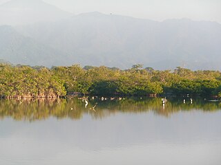
Cần Giờ Biosphere Reserve is a wetland located 40 km southeast coastal area of Ho Chi Minh City. This reserve has been listed as a biosphere reserve by UNESCO. The site is an important wildlife sanctuary in Vietnam as it is characterized by a wetland biosystem dominated by mangrove and many rare species.
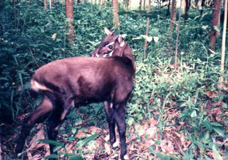
The wildlife of Vietnam is rich in flora and fauna as reflected by its unique biodiversity. Saola, rare and antelope-like animal categorized under the bovine subfamily, was found in 1992 in Vũ Quang National Park. In the 1990s, three other muntjac species, the deer-like Truong Son muntjac, giant muntjac and Pu Hoat muntjac, were also discovered. Conservation protection and scientific studies of the ecology of Vietnam, particularly in the protected forest areas, have been given priority attention by the Government of Vietnam. Laws were enacted to set up Xuân Thủy Wetland National Park, four UNESCO Biosphere Reserves, and Hạ Long Bay and Phong Nha-Kẻ Bàng National Parks; the last two are also designated as UNESCO World Heritage Sites.
Gornje Podunavlje Special Nature Reserve is a large protected area of wetland in the northwest of Serbia, on the Danube's left bank. It comprises two large marshes, Monoštorski Rit and Apatinski Rit and vast forests, meadows, ponds, swamps and the Danube's meanders, including 66 km (41 mi) of the Danube course. It is a part of the trans-boundary biosphere reserve "Mura-Drava-Danube", a five country project, dubbed the "Amazon of Europe".

Bundala National Park is an internationally important wintering ground for migratory water birds in Sri Lanka. Bundala harbors 197 species of birds, the highlight being the greater flamingo, which migrate in large flocks. Bundala was designated a wildlife sanctuary in 1969 and redesignated to a national park on 4 January 1993. In 1991 Bundala became the first wetland to be declared as a Ramsar site in Sri Lanka. In 2005 the national park was designated as a biosphere reserve by UNESCO, the fourth biosphere reserve in Sri Lanka. The national park is situated 245 kilometres (152 mi) southeast of Colombo.
Giao Xuân is a commune in Giao Thủy District, Nam Định, Vietnam approximately 150 km South-East of Hanoi. It has a population of 10,000 people.

Xuân Thủy National Park is a national park in Hong River Biosphere Reserve in Nam Định Province, Vietnam. The national park was established according to the Decision number 01/2003/QĐ-TTg dated 2 January 2003 signed by premier Nguyễn Tấn Dũng, this decision turned Xuân Thủy Wetland Nature Reserve into Xuân Thủy National Park. The park was the first wetland area to be announced a Ramsar site in south-east Asia and is internationally significant as a migratory bird habitat.

Cu Lao Cham Marine Park also known as Cham Islands Biosphere Reserve is part of the eight islets of the Chàm Islands, located in the South China Sea under the administration of Tân Hiệp Commune and Hội An town, in Quảng Nam Province, Vietnam. The terrestrial and coastal ecosystems of the islands have been recognized as a global Biosphere Reserve by UNESCO on 26 May 2009 under its 'Man and the Biosphere Programme' for its rich biodiversity value. The eco system also includes the ancient Hội An, which is 20 kilometres (12 mi) away from the islands, a UNESCO World Heritage Site.

The Messalo is a major river of northeastern Mozambique. It flows through Niassa Province and Cabo Delgado Province, passes near Chai, and flows into the Mozambique Channel of the Indian Ocean at Quiterajo beach at 11°40′25″S40°26′25″E. The Messalo River is 530 km (330 mi) in length while the Messalo River Basin is 24,000 km2 (9,300 sq mi) in size. The river flooded its banks in March 2000 during the 2000 Mozambique flood.
Many areas of Vietnam are under protection. While the national reserves cover small areas of scientific significance with restricted access, the national parks also cover wetlands of Ramsar designated areas and BirdLife International inscribed bird areas. The largest of the national parks initially covered were the Cúc Phương National Park, the Cát Tiên National Park, and the Côn Đảo National Park which to start with were forest areas cum reserves or prohibited areas. The objective for creating national parks was to allow access to the reserved areas as a part of ecotourism and cultural needs with full attention to the basic approach of conservation of natural environmental resources.
The Tana River Delta Ramsar Site is a wetland on the Tana River protected under the Ramsar Convention located in the Coast Province of Kenya. It was gazetted as Kenya's 6th Ramsar Site.

Alto Golfo de California Biosphere Reserve is a UNESCO Biosphere Reserve located in the state of Sonora in extreme northwestern Mexico. Thee 1,652,110 hectares (6,378.8 sq mi) reserve comprises the El Pinacate y Gran Desierto reserve and the Bahia Adair on the Gulf of California border. Geological volcanic formations with craters, dunes, oasis and beaches, and the diversity of plant associations determine its special landscape. The reserve was established in 1993 by the President of Mexico as Reserva de la Biosfera del Alto Golfo de California y Delta del Río Colorado and extended in 1995.

Waterton Biosphere Region is a UNESCO Biosphere Reserve encompassing Waterton Lakes National Park in the extreme southwest of the Province of Alberta, Canada. The region includes a section of the east slopes of the Rocky Mountains extending from the Continental Divide to the edge of the Canadian Great Plains to the east, including the Municipality of Pincher Creek and Cardston County. The Glacier Biosphere Reserve and National Park in Montana, USA is located to the south of the area.
The Brighton and Lewes Downs Biosphere Reserve is a UNESCO Biosphere Reserve located in Sussex on the southeast coast of England near the city of Brighton and Hove. Forming a central unit of the hills of the South Downs National Park, it is centred on the Brighton chalk block that lies between the River Adur in the west and the River Ouse in the east. Chalk downland makes up the principal terrestrial landscape of the area, bounded at each end by the two river valleys. The coastline is dominated by high chalk cliffs in the east and urbanized plains in the west, running to the estuary of the River Adur at Shoreham-by-Sea.

The Ciénaga de Zapata Biosphere Reserve is a UNESCO Biosphere Reserve situated on the southern coast of Cuba at Matanzas province. The 628,171 hectares (2,425.38 sq mi) reserve encompasses the Zapata Swamp and is one of the largest and most important wetlands in the Caribbean region with a marine southern borderline. Ciénaga de Zapata was designated a Ramsar site in 2001. This area is a cluster biosphere reserve with several core areas, highly valuable for conservation located in the Ciénaga de Zapata National Park.

Ría Lagartos Biosphere Reserve is a UNESCO Biosphere Reserve in the state of Yucatán, Mexico. The reserve is located at the eastern end of the coastal strip of the Yucatán Peninsula, with the Gulf of Mexico at its northern limit. The area encompasses coastal areas of the Gulf of Mexico and includes important wetlands designated under the Ramsar Wetlands Convention. The site presents a rich diversity of landscapes and ecosystems, such as mangroves, small estuaries, medium semi-evergreen forest, low deciduous forest, coastal dune vegetation, coastal lagoons, marshes (petenes) and savanna represented by tular vegetation, grasslands and reed beds that are the main nesting sites for marshland and sea birds.
La Encrucijada Biosphere Reserve is a UNESCO Biosphere Reserve situated in the Pacific Coastal Lowlands physiographic region of Mexico. It covers 144,848 hectares (559.26 sq mi) stretching over six municipalities in the Costa de Chiapas. It is composed of two large coastal lagoon systems that correspond to two core areas, and a wide variety of natural ecosystems including mangroves, zapotonales, tule swamps and marshes, as well as patches of tropical seasonal forest, coastal dunes and palm trees.

The Guianan mangroves (NT1411) is a coastal ecoregion of southeastern Venezuela, Guyana, Suriname, French Guiana and Brazil. The mangroves provide an important habitat for migrating birds that winter in the area. Large areas are intact, although they are threatened by destruction of the trees for timber and to make way for agriculture, and from upstream agricultural and industrial pollution.
The Sundarbans Biosphere Reserve is a biosphere reserve in the Indian state of West Bengal, based on the UNESCO Man and the Biosphere (MAB) Programme list. It is one of the 18 biosphere reserves in India and the third largest in terms of area. The Biosphere Reserve is constituted of the Sundarbans area spread across South 24 Parganas and North 24 Parganas district districts of West Bengal. The Indian Sundarbans as a Biosphere Reserve is bounded by the Muri Ganga River in the west and the Hariabhanga and Raimangal rivers in the east. Sundarbans has a very rich diversity of aquatic and terrestrial flora and fauna. In fact, the highly productive ecosystems of the Sundarbans act as natural fish nurseries. It provides habitat for the Royal Bengal Tiger.

