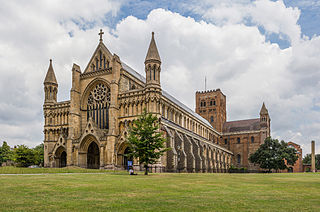
St Albans Cathedral, officially the Cathedral and Abbey Church of St Alban but often referred to locally as "the Abbey", is a Church of England cathedral in St Albans, England. Much of its architecture dates from Norman times. It ceased to be an abbey following its dissolution in the 16th century and became a cathedral in 1877. Although legally a cathedral church, it differs in certain particulars from most other cathedrals in England, being also used as a parish church, of which the dean is rector with the same powers, responsibilities and duties as that of any other parish. At 85 metres long, it has the longest nave of any cathedral in England.
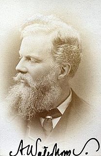
Alfred Waterhouse was an English architect, particularly associated with the Victorian Gothic Revival architecture, although he designed using other architectural styles as well. He is perhaps best known for his designs for Manchester Town Hall and the Natural History Museum in London, although he also built a wide variety of other buildings throughout the country. Besides his most famous public buildings he designed other town halls, the Manchester Assize buildings—bombed in World War II—and the adjacent Strangeways Prison. He also designed several hospitals, the most architecturally interesting being the Royal Infirmary Liverpool and University College Hospital London. He was particularly active in designing buildings for universities, including both Oxford and Cambridge but also what became Liverpool, Manchester and Leeds universities. He designed many country houses, the most important being Eaton Hall in Cheshire, largely demolished in 1961-63. He designed several bank buildings and offices for insurance companies, most notably the Prudential Assurance Company. Although not a major church designer he produced several notable churches and chapels. He was both a member of The Royal Institute of British Architects, of which he served a term as President, and a Royal Academician, acting as Treasurer for the Royal Academy.

The Worshipful Company of Tylers and Bricklayers is one of the livery companies of the City of London. The organisation of Tylers and Bricklayers existed in 1416; it was incorporated by a royal charter in 1568. Originally, the company possessed a monopoly over bricklaying within the City of London. However, after the Great Fire of London, the king decreed that brick or stone, instead of timber, should be used in the building of homes. There was too much rebuilding to be done by only the Tylers' and Bricklayers' Company; craftsmen from across England were summoned, and the monopoly was terminated. The company now exists, along with most livery companies, primarily as a charitable body. The company also supports various building schools.

The London Wall was a defensive wall first built by the Romans around the strategically important port town of Londinium in c. AD 200. It has origins as an initial mound wall and ditch from c. AD 100 and an initial fort, now called Cripplegate fort after the city gate (Cripplegate) that was positioned within its northern wall later on, built in 120-150 where it was then expanded upon by Roman builders into a city-wide defence. Over time, as Roman influence waned through the departure of the Roman army in c. 410, their withdrawal led to its disrepair, as political power on the island dispersed through the Heptarchy period of Anglo-Saxon England. From the conquest of William the Conqueror, successive medieval restorations and repairs to its use have been undertaken. This wall largely defined the boundaries of the City of London until the later Middle Ages, when population rises and the development of towns around the city blurred the perimeter.
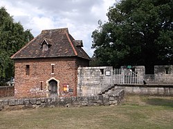
A postern is a secondary door or gate in a fortification such as a city wall or castle curtain wall. Posterns were often located in a concealed location which allowed the occupants to come and go inconspicuously. In the event of a siege, a postern could act as a sally port, allowing defenders to make a sortie on the besiegers. Placed in a less exposed, less visible location, they were usually relatively small, and therefore easily defensible.

Fishergate is a street and surrounding area of York, England.

York has, since Roman times, been defended by walls of one form or another. To this day, substantial portions of the walls remain, and York has more miles of intact wall than any other city in England. They are known variously as York City Walls, the Bar Walls and the Roman walls. The walls are generally 13 feet (4m) high and 6 feet (1.8m) wide.

The siege of York in 1644 was a prolonged contest for York during the First English Civil War, between the Scottish Covenanter army and the Parliamentarian armies of the Northern Association and Eastern Association, and the Royalist Army under the Marquess of Newcastle. It lasted from 22 April until 1 July when the city was relieved by Prince Rupert of the Rhine. Rupert and Newcastle were defeated the next day at the decisive Battle of Marston Moor, and the siege resumed until the city was surrendered on easy terms on 16 July.
York had around forty-five parish churches in 1300. Twenty survive, in whole or in part, a number surpassed in England only by Norwich, and twelve are currently used for worship. This article consists of, first, a list of medieval churches which still exist in whole or in part, and, second, a list of medieval churches which are known to have existed in the past but have been completely demolished.

Icknield Street School, near the Hockley Flyover, north of the Jewellery Quarter, Birmingham, England, is a good example of a Birmingham board school. It is owned by Birmingham City Council.

St Werburgh's Church is the name of two separate churches in the village of Warburton, Greater Manchester, England. The older church is located to the west of the village, and may date back as far as the middle of the 13th century. It is now a redundant church but services are held in the summer months. The church is recorded in the National Heritage List for England as a designated Grade I listed building. The authors of the Buildings of England series call this church "a lovable muddle".
Layerthorpe is a village in the unitary authority area of the City of York, North Yorkshire, England. It is outside the city walls of York. The road through Layerthorpe from the bridge over the River Foss to Heworth is also shares the same name.

St Denys' Church, York is a Grade I listed parish church in the Church of England on Walmgate in York.
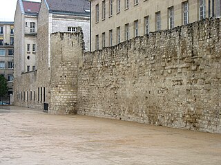
The Wall of Philip Augustus is the oldest city wall of Paris (France) whose plan is accurately known. Partially integrated into buildings, more traces of it remain than of the later fortifications.

St Anne's Church is an Anglican church in St Anne's-on-the-Sea, a town on the Fylde coastal plain in Lancashire, England. It is an active Church of England parish church in the Diocese of Blackburn and the archdeaconry of Lancaster. It is recorded in the National Heritage List for England as a designated Grade II listed building.

Lendal Tower is a medieval tower that formed part of the city defences of York, England. It is located on the east bank of the River Ouse at the point where the river enters the walled city from the north-west. The building was used as a waterworks from 1616 until 1846 after which it was converted into offices. It has since been turned into rental accommodation.

Piccadilly is a street in the city centre of York, in England.

Walmgate is a street in the city centre of York, in England. During the Medieval period, the street was the site of a seafissh and cattle market. Walmgate Bar, was involved in the Siege of York in 1644, during the First English Civil War. During the 20th century, many of the older buildings were cleared away and newer structures put up.
Lawrence Street is a road in York, in England, immediately south-east of the city centre.

Tower Street is a road in the city centre of York, in England.