Lee County is located in southwest Florida on the Gulf Coast. As of the 2010 census, the population was 618,754. The county seat is Fort Myers, and the largest city is Cape Coral with an estimated 2016 population of 179,804. Lee County comprises the Cape Coral–Fort Myers, FL Metropolitan Statistical Area.

Captiva is a census-designated place in Lee County, Florida, United States. It is located on Captiva Island. As of 2015 the CDP had a total year-round population of 379. It is part of the Cape Coral-Fort Myers, Florida Metropolitan Statistical Area.

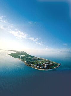
Sanibel is an island and city in Lee County, Florida, United States. The population was 6,469 at the 2010 census, with an estimated 2012 population of 6,741. It is part of the Cape Coral-Fort Myers, Florida Metropolitan Statistical Area. The island, also known as Sanibel Island, constitutes the entire city. It is a barrier island – a collection of sand on the leeward side of the more solid coral-rock of Pine Island.

Hurricane Charley was the first of four individual hurricanes to impact or strike Florida during 2004, along with Frances, Ivan and Jeanne, as well as one of the strongest hurricanes ever to strike the United States. It was the third named storm, the second hurricane, and the second major hurricane of the 2004 Atlantic hurricane season. Charley lasted from August 9 to 15, and at its peak intensity it attained 150 mph (240 km/h) winds, making it a strong Category 4 hurricane on the Saffir-Simpson Hurricane Scale. It made landfall in Southwest Florida at maximum strength, making it the strongest hurricane to hit the United States since Hurricane Andrew struck Florida in 1992 and the strongest hurricane to hit southwest Florida since Hurricane Donna in 1960.

Captiva Island is an island in Lee County, Florida, located just offshore in the Gulf of Mexico. Captiva Island is just north of Sanibel Island.
Pine Island is the largest island in the state of Florida in the United States. The island is located in Lee County, on the Gulf of Mexico coast of southwest Florida, it is also the 118th largest island in the United States. The Intracoastal Waterway passes through Pine Island Sound, to the west of the island. Matlacha Pass runs between Pine Island and the mainland. Pine Island lies west of Cape Coral. For many years Pine Island was a major commercial fishing community and many of its full-time residents still commercial fish today.

The Sanibel Causeway is a causeway in Southwest Florida that spans the San Carlos Bay, connecting Sanibel Island with the Florida mainland in Punta Rassa. The causeway consists of three separate two-lane bridge spans, and two man-made causeway islands between them. The entire causeway facility is owned by Lee County and operated by the Lee County Department of Transportation. The entire causeway is three miles long from end to end, and currently has a $6 toll in effect for island-bound vehicles only. The bridges are not individually named, and are simply referred to as bridges A, B, and C. The islands are also named A and B. Both series begin from the mainland side.
The red drum, also known as channel bass, redfish, puppy drum, spottail bass, or simply red, is a game fish found in the Atlantic Ocean from Massachusetts to Florida and in the Gulf of Mexico from Florida to northern Mexico. It is the only species in the genus Sciaenops. The red drum is related to the black drum, and the two species are often found in close proximity to each other; they can interbreed and form a robust hybrid, and younger fish are often indistinguishable in flavor.
Blind Pass is the strait that separates Captiva Island from Sanibel Island in Lee County, Florida.

The Bailey-Matthews National Shell Museum is a museum devoted to every aspect of seashells, conchology, and malacology, including the paleontological and archeological/anthropological aspects of the study of shells. The museum is located in the city of Sanibel on Sanibel Island on the Gulf of Mexico coast of Southwest Florida.
South Seas Island Resort is a 330-acre (1.3 km2) resort located on the shores of the Gulf of Mexico in the community of Captiva on Captiva Island, in Lee County, Florida. The original resort, South Seas Plantation, was opened in 1946 as a fishing resort by Clarence Chadwick, following a dry hurricane which ended commercial farming on the island. Chadwick owned much of Captiva and portions of nearby Sanibel, making his fortune inventing the Checkprinter in the 1920s. His heirs sold the property to Mariner Properties in 1966, which began the modern era of the resort. The original Plantation house, suffering from termites and wood rot, was demolished in the 1990s.

The Chassahowitzka River is a spring-fed river located in southwestern Citrus County, Florida. The 5-mile-long (8 km) river is home to hundreds of species of birds including the bald eagle, and is a common refuge for the West Indian manatee. In 1941, approximately 31,000 acres (13,000 ha) of its saltwater creeks, freshwater tributaries, and hardwood hammocks were recognized as Chassahowitzka National Wildlife Refuge. It is accessible by boat from a nearby public boat ramp that is located at the campground that also bears its Indian name which means "land of hanging pumpkins;" a reference to a wild variety that once grew along the banks.
North Captiva Island is an island in Lee County in Southwest Florida, located just offshore in the Gulf of Mexico. It lies just north of Captiva Island, separated by a channel called Redfish Pass which was created in a 1921 hurricane. It lies just south of Cayo Costa Island, separated by Captiva Pass.
Captiva Pass is the strait that separates North Captiva Island from La Costa Island in Lee County, Florida.
Little Gasparilla Island is a barrier island in southwest Florida, in Charlotte County. It is just north of Gasparilla Island, separated by Gasparilla Pass. It lies west of the town of Placida, separated by Placida Harbor. It is connected with Don Pedro Island to the north by a thin strip of beach and mangrove swamp. It borders the Gulf of Mexico to the west. Little Gasparilla Island can be reached by water taxi from Placida.
Gasparilla Pass is an inlet southwest of the town of Placida, Florida, United States. It connects Placida Harbor with the Gulf of Mexico separating Gasparilla Island on the south from Little Gasparilla Island on the north.

The fifth US Coast Guard cutter named Mohawk (WPG-78) was built by Pusey & Jones Corp., Wilmington, Delaware, and launched 1 October 1934. She was commissioned on 19 January 1935.

Redfish Bay is a southwestern extension of Aransas Bay in Texas, north of Corpus Christi Bay. It separates the cities of Aransas Pass and Ingleside from Port Aransas on Mustang Island.
Punta Gorda Fish Co. was a fishing company established in the late 19th century in Punta Gorda, Florida. At least ten of the fish shacks and icehouses built by the company have been listed on the National Register of Historic Places.


