Escambia Bay

Last updated
Escambia Bay (upper center) is east of Pensacola, Florida. Florida-Pensacola-map-legend-X-6-1756-FAA.gif
Escambia Bay (upper center) is east of Pensacola, Florida.

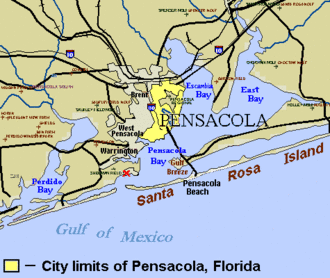
Escambia Bay is a bay located in Escambia and Santa Rosa counties, in the far western Florida Panhandle. The city of Pensacola is located on the western side, and the town of Milton is located on the northeastern end of the two-pronged bay. Both places are the county seats of the respective counties. Unusually, Escambia Bay is connected to open waters via Pensacola Bay to its southeast. It is fed primarily by the Escambia River [1] .

National Airlines Flight 193, a Boeing 727, crashed into Escambia Bay during a descent into Pensacola Regional Airport on May 8, 1978. There were 3 fatalities among the 58 people on board.

During Hurricane Ivan in September 2004, the storm surge from the Gulf of Mexico came into Escambia Bay, washing out the Interstate 10 Escambia Bay Bridge.

Coordinates: 30°32′29″N87°09′08″W / 30.54139°N 87.15222°W / 30.54139; -87.15222


  1. "Escambia Bay, Florida". guidesly.com. Retrieved 2022-12-10.

Related Research Articles

<span class="mw-page-title-main">Escambia County, Florida</span> County in Florida, United States

Escambia County is the westernmost and oldest county in the U.S. state of Florida. It is in the state's northwestern corner. At the 2020 census, the population was 321,905. Its county seat and largest city is Pensacola. Escambia County is included within the Pensacola-Ferry Pass-Brent, Florida, Metropolitan Statistical Area. The county population has continued to increase as the suburbs of Pensacola have developed.

<span class="mw-page-title-main">Santa Rosa County, Florida</span> County in Florida, United States

Santa Rosa County is a county located in the northwestern portion of the U.S. state of Florida. As of 2020, the population is 188,000. The county seat is Milton, which lies in the geographic center of the county. Other major communities within Santa Rosa County are Navarre, Pace, and Gulf Breeze. Navarre is the most populated community with a population of approximately 45,000 residents. Santa Rosa County is included in the Pensacola Metropolitan Statistical Area, which also includes Escambia County.

<span class="mw-page-title-main">Flomaton, Alabama</span> Town in Alabama, United States

Flomaton is a town in Escambia County, Alabama, United States. At the 2010 census the town's population was 1,440. It is located next to the Alabama / Florida state line.

<span class="mw-page-title-main">Brent, Florida</span> Census-designated place in Florida, United States

Brent is a census-designated place (CDP) in Escambia County, Florida, United States. The population was 21,804 at the 2010 census. It is a principal city of the Pensacola-Ferry Pass-Brent Metropolitan Statistical Area. The community is named after Francis Celestino Brent, who played an integral role in the development of Pensacola.

<span class="mw-page-title-main">Century, Florida</span> Town in Florida, United States

Century is a town in Escambia County, Florida, United States. Per the 2020 census, the population was 1,713. It is part of the Pensacola–Ferry Pass–Brent Metropolitan Statistical Area.

<span class="mw-page-title-main">Ferry Pass, Florida</span> Census-designated place in Florida, United States

Ferry Pass is a census-designated place (CDP) in Escambia County, Florida. It is a community in Pensacola, and is located north of Pensacola City Limits. As of the 2010 United States Census, the population was 28,921. The University of West Florida, located in Ferry Pass, is the only university located in the Pensacola Metropolitan Area.

<span class="mw-page-title-main">Pensacola, Florida</span> City in Florida, United States

Pensacola is the westernmost city in the Florida Panhandle, and the county seat and only incorporated city of Escambia County, Florida, United States. As of the 2020 United States census, the population was 54,312. Pensacola is the principal city of the Pensacola Metropolitan Area, which had an estimated 502,629 residents as of 2019.

<span class="mw-page-title-main">Warrington, Florida</span> CDP in Florida, United States

Warrington is a census-designated place (CDP) in Escambia County, Florida, United States. Warrington is located between downtown Pensacola and the state line with Alabama; it is 6 miles (10 km) away from both.

<span class="mw-page-title-main">Pensacola Beach, Florida</span> Unincorporated Community in Florida, United States

Pensacola Beach is an unincorporated community located on Santa Rosa Island, a barrier island, in Escambia County, Florida, United States. It is situated south of Pensacola in the Gulf of Mexico. As of the 2000 census, the community had a total population of 2,738. It has been described as "famous" for its ultra-white sand beaches.

<span class="mw-page-title-main">Florida Panhandle</span> Northwest region of Florida

The Florida Panhandle is the northwestern part of the U.S. state of Florida; it is a salient roughly 200 miles (320 km) long and 50 to 100 miles wide, lying between Alabama on the north and the west, Georgia on the north, and the Gulf of Mexico to the south. Its eastern boundary is arbitrarily defined. In terms of population, major communities include Tallahassee, Pensacola, and Panama City.

<span class="mw-page-title-main">Pensacola Bay Center</span> Arena in Florida, U.S.

Pensacola Bay Center is an indoor arena located in Pensacola, Florida. It is owned by Escambia County and operated by ASM Global. The Bay Center has a capacity of 8,049 for hockey games, and as much as 10,000 for non-hockey events. The arena contains 23,000 square feet (2,100 m2) of space and 10,000 square feet (1,000 m2) of meeting space.

<span class="mw-page-title-main">Pensacola Bay</span> A bay in the northwestern part of Florida, United States, known as the Florida Panhandle

Pensacola Bay is a bay located in the northwestern part of Florida, United States, known as the Florida Panhandle.

<span class="mw-page-title-main">Perdido Bay</span>

Perdido Bay is a bay at the mouth of and draining the Perdido River, a designated Outstanding Florida Waters river, in Baldwin County, Alabama and Escambia County, Florida, United States. It is essentially a coastal lagoon enclosed by barrier islands, with an inlet, Perdido Pass.

<span class="mw-page-title-main">Florida State Road 298</span>

State Road 298, known locally as Lillian Highway, is a mostly east–west thoroughfare in Pensacola, Florida. It runs from its intersection with U.S. Highway 98 and Dog Track Road, skirting Perdido Bay on its way east to its terminus at the West Pensacola spur of SR 295. SR 298 passes under the mainline of SR 295 without an interchange. It serves as a major route through the communities of Myrtle Grove and West Pensacola.

Barrineau Park is an unincorporated community in Escambia County, Florida, United States. It is approximately 5 miles (8.0 km) west of Molino and a few miles from the Perdido River. It is a rural community of low hills, farms, creeks and woods.

Innerarity Point is an unincorporated community in Escambia County, Florida, United States. It is part of the Pensacola–Ferry Pass–Brent Metropolitan Statistical Area. Innerarity Point is located north of Perdido Key.

<span class="mw-page-title-main">Pensacola Pass</span>

Pensacola Pass, separating mainland Florida from Santa Rosa Island, is the mouth of Pensacola Bay. Pensacola Pass forms a water passage that connects Pensacola Bay with the Gulf of Mexico to the south, in the U.S. state of Florida, east of the Alabama/Florida state line. The surrounding area is heavily developed, with high-rise condominiums. However, there are nearby beach-front parks, with Fort Pickens on the eastern side of Pensacola Pass.

McDavid is an unincorporated community in Escambia County, Florida, United States. The community is part of the Pensacola – Ferry Pass – Brent, Florida Metropolitan Statistical Area. The ZIP Code for McDavid is 32568.

Brownsville is an unincorporated community in Escambia County, Florida, United States. It is located within the census-designated place of West Pensacola. It was enumerated as a Census-Designated Place in 1960, when the population recorded was 38,417. The ZIP code for Brownsville is 32505.

<span class="mw-page-title-main">Millview, Florida</span> Unincorporated community in Florida, United States

Millview is an unincorporated community located along Perdido Bay in Escambia County, Florida, United States.