
Miami, officially the City of Miami, is a coastal metropolis and the county seat of Miami-Dade County in South Florida. With a population of 442,241 as of the 2020 census, it is the second-most populous city in Florida and 11th-most populous city in the Southeast. The Miami metropolitan area is the ninth-largest in the United States with a population of 6.138 million in 2020. The city has the third largest skyline in the U.S. with over 300 high-rises, 58 of which exceed 491 ft (150 m).

Cutler Bay is an incorporated town in Miami-Dade County, Florida, United States, established in 2005. With a population of 45,425 as of the 2020 census, Cutler Bay is the 9th most populous of the 34 municipalities that make up Miami's urban core, and the 33rd most populous of the 163 municipalities that make up the Miami-Fort Lauderdale-Pompano Beach Metropolitan Area.
Key Biscayne is an island town in Miami-Dade County, Florida, United States. The population was 14,809 at the 2020 census, up from 12,344 in 2010.
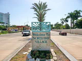
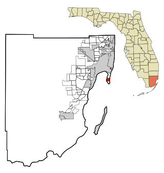
North Bay Village is a city located in Miami-Dade County, Florida. As of the 2020 census, the city had a total population of 8,159. North Bay Village is located at 25°50′44″N80°09′13″W.

North Miami is a suburban city located in northeast Miami-Dade County, Florida, United States, about 10 miles (16 km) north of Miami. The city lies on Biscayne Bay and hosts the Biscayne Bay Campus of Florida International University, and the North Miami campus of Johnson & Wales University. Originally the town of "Arch Creek", the area was incorporated as the "Town of Miami Shores", which was renamed the "Town of North Miami" in 1931. It was reincorporated as a city in 1953.

Biscayne National Park is an American national park located south of Miami, Florida in Miami-Dade County. The park preserves Biscayne Bay and its offshore barrier reefs. Ninety-five percent of the park is water, and the shore of the bay is the location of an extensive mangrove forest. The park covers 172,971 acres and includes Elliott Key, the park's largest island and northernmost of the true Florida Keys, formed from fossilized coral reef. The islands farther north in the park are transitional islands of coral and sand. The offshore portion of the park includes the northernmost region of the Florida Reef, one of the largest coral reefs in the world.

Florida International University (FIU) is a public research university with its main campus in Miami-Dade County. Founded in 1965, the school opened its doors to students in 1972. FIU has grown to become the third-largest university in Florida and the fifth-largest public university in the United States by enrollment. FIU is a constituent part of the State University System of Florida. In 2021, it was ranked #1 in the Florida Board of Governors performance funding, and had over $246 million in research expenditures.

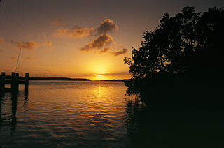
Biscayne Bay is a lagoon with characteristics of an estuary located on the Atlantic coast of South Florida. The northern end of the lagoon is surrounded by the densely developed heart of the Miami metropolitan area while the southern end is largely undeveloped with a large portion of the lagoon included in Biscayne National Park.
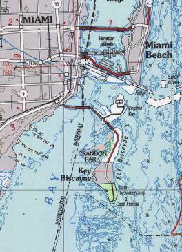
Key Biscayne is an island located in Miami-Dade County, Florida, located between the Atlantic Ocean and Biscayne Bay. It is the southernmost of the barrier islands along the Atlantic coast of Florida, and lies south of Miami Beach and southeast of Miami. The key is connected to Miami via the Rickenbacker Causeway, originally built in 1947.

Miami Modernist architecture, or MiMo, is a regional style of architecture that developed in South Florida during the post-war period. The style was internationally recognized as a regionalist response to the International Style. It can be seen in most of the larger Miami and Miami Beach resorts built after the Great Depression. Because MiMo styling was not just a response to international architectural movements but also to client demands, themes of glamour, fun, and material excess were added to otherwise stark, minimalist, and efficient styles of the era. The style can be most observed today in Middle and Upper Miami Beach along Collins Avenue, as well as along the Biscayne Boulevard corridor starting from around Midtown, through the Design District and into the Upper Eastside.

Julia DeForest Tuttle was an American businesswoman who owned the property upon which Miami, Florida, was built. For this reason, she is called the "Mother of Miami." She is the only woman to have founded what would become a major American city.

Card Sound Bridge is a high-rise toll causeway connecting southern Miami-Dade County and northern Monroe County. It is one of only two ways that motorists can leave or enter the Florida Keys. The toll for two-axle automobiles is USD $1.50 if paid via SunPass. The prior toll plaza was demolished during hurricane Matthew and has been replaced with a toll-by-plate plaza. The toll fee will be charged by plate automatically and sent via the mail to the address on the vehicle registration. The cashless all-electronic tolling system replaced the previous staffed toll booth on October 20, 2018. The toll fee is waived upon evacuating the Keys for hurricanes or in instances in which US 1 is impassable.

Elliott Key is the northernmost of the true Florida Keys, and the largest key north of Key Largo. It is located entirely within Biscayne National Park, in Miami-Dade County, Florida, east of Homestead, Florida. It is bordered by the Atlantic Ocean to the east, Biscayne Bay to the west, Sands Key to the north and Old Rhodes Key to the south. Adams Key is just west of the southern end of Elliott Key. Elliott Key is about seven miles (11 km) long. Its maximum width is about 2,500 feet (760 m) near the north end and its average width is less than 2,000 feet (610 m). The higher elevations on the island range from 6 to 8 feet above sea level and occur generally along an unimproved road that runs longitudinally through the center of the island. The average elevation is about 3 feet (0.91 m) above sea level. The key is accessible only by boat. Elliott Key has a National Park Service campground, but is otherwise uninhabited.

The Rickenbacker Causeway is a causeway that connects Miami, Florida to the barrier islands of Virginia Key and Key Biscayne across Biscayne Bay.

U.S. Highway 1 (US 1) in Florida runs 545 miles (877 km) along the state's east coast from Key West to its crossing of the St. Marys River into Georgia north of Boulogne and south of Folkston. US 1 was designated through Florida when the U.S. Numbered Highway System was established in 1926. The road is maintained by the Florida Department of Transportation (FDOT).
Adams Key is an island north of the upper Florida Keys in Biscayne National Park. It is in Miami-Dade County, Florida. It is located west of the southern tip of Elliott Key, on the north side of Caesar Creek in the lower part of Biscayne Bay. The key is only accessible by boat, and overnight docking is prohibited.
Soldier Key is an island in Biscayne National Park in Miami-Dade County, Florida. It is located between Biscayne Bay and the Atlantic Ocean, about three miles north of the Ragged Keys, five miles south of Cape Florida on Key Biscayne, seven-and-a-half miles east of the mainland and three miles west of Fowey Rocks. It lies on the Safety Valve, a sand bar that separates Biscayne Bay from the Atlantic Ocean and moderates storm surges into the bay.

The Florida Reef is the only living coral barrier reef in the continental United States. It is the third largest coral barrier reef system in the world. It lies a few miles seaward of the Florida Keys, is about 4 miles wide and extends 270 km (170 mi) from Fowey Rocks just east of Soldier Key to just south of the Marquesas Keys. The barrier reef tract forms a great arc, concentric with the Florida Keys, with the northern end, in Biscayne National Park, oriented north-south and the western end, south of the Marquesas Keys, oriented east-west. The rest of the reef outside Biscayne National Park lies within John Pennekamp Coral Reef State Park and the Florida Keys National Marine Sanctuary. Isolated coral patch reefs occur northward from Biscayne National Park as far north as Stuart, in Martin County. Coral reefs are also found in Dry Tortugas National Park west of the Marquesas Keys. There are more than 6,000 individual reefs in the system. The reefs are 5,000 to 7,000 years old, having developed since sea levels rose following the Wisconsinan glaciation.

Alice Wainwright Park is a 28-acre (11 ha) waterfront park and nature preserve located in northern Coconut Grove, Miami, Florida, U.S.A., on the southern border of Brickell. It is named for Alice C. Wainwright, who was the first woman elected to serve on the City of Miami Commission.

The Central Business District (CBD) of Miami is the historic central business district and city center of what has become Greater Downtown Miami in Miami, Florida. Over 92,000 people work in Miami's Central Business District.
