
Weymouth and Portland was a local government district and borough in Dorset, England. It consisted of the resort of Weymouth and the Isle of Portland, and includes the areas of Wyke Regis, Preston, Melcombe Regis, Upwey, Broadwey, Southill, Nottington, Westham, Radipole, Chiswell, Castletown, Fortuneswell, Weston, Southwell and Easton; the latter six being on the Isle of Portland.

West Dorset was a local government district in Dorset, England. Its council was based in Dorchester. The district was formed on 1 April 1974, under the Local Government Act 1972, and was a merger of the boroughs of Bridport, Dorchester and Lyme Regis, along with Sherborne urban district, and the rural districts of Beaminster, Bridport, Dorchester and Sherborne.
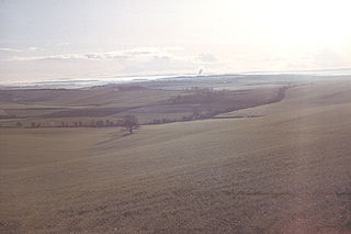
The Dorset Downs are an area of chalk downland in the centre of the county Dorset in south west England. The downs are the most western part of a larger chalk formation which also includes Cranborne Chase, Salisbury Plain, Hampshire Downs, Chiltern Hills, North Downs and South Downs.

Abbotsbury Castle is an Iron Age hill fort in south west Dorset, England, situated on Wears Hill above the village of Abbotsbury, seven miles west of Dorchester and the famous hill fort at Maiden Castle.

South Dorset is a constituency represented in the House of Commons of the UK Parliament since 2010 by Richard Drax, a Conservative. The constituency was created as a consequence of the Redistribution of Seats Act 1885, although the area covered has changed since then.
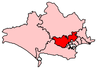
Mid Dorset and North Poole is a constituency represented in the House of Commons of the UK Parliament since 2015 by Michael Tomlinson, a Conservative.

The Moors River is a river in east Dorset, England, which starts at the point where the River Crane and the Ebblake Stream meet, at Ebblake, south of Verwood.
Beaminster Forum & Redhone Hundred was a hundred in the county of Dorset, England, containing the following parishes:

Redford is an unincorporated community in Reynolds County, Missouri, United States. It is located on Misssour Route O approximately eight miles south-southeast of Centerville. Ellington is six miles to the southwest. Sinking Creek flows past the southwest side of the community.

Newton's Cove is a small cove, 0.5 kilometres (0.3 mi) south of Weymouth, Dorset, England. Overlooking Portland Harbour, the cove is close to Nothe Gardens and the Nothe Fort.

Dorset County Council (DCC) was the county council for the county of Dorset in England. It provided the upper tier of local government, below which were district councils, and town and parish councils. The county council had 46 elected councillors and was based at County Hall in Dorchester. The council was abolished on 31 March 2019 as part of structural changes to local government in Dorset.

Bournemouth Borough Council was the local authority of Bournemouth in Dorset, England and ceased to exist on 1 April 2019. It was a unitary authority, although between 1974 and 1997 it was an administrative district council with Dorset. Previously most of the borough was part of Hampshire.

Dean Park is a cricket ground in Bournemouth, England, currently used by Bournemouth University Cricket Club, as well as by Parley Cricket Club and Suttoners Cricket Club. It was formerly used by Hampshire and Dorset County Cricket Clubs. This venue has now been bought by Bournemouth Park School. This building has since been transformed into a children's daycare facility.

The Spittles is an area of coastal cliff in the county of Dorset on the south coast of England. It is situated between the settlements of Lyme Regis to the west and Charmouth to the east. It forms part of the Jurassic Coast, a World Heritage Site designated in 2001. The cliff contains layers of Blue Lias and clay; in wet seasons the clay causes the layers above to become saturated and hence landslips occur, exposing many fossils. Mary Anning famously found an Ichthyosaurus in the Spittles.

Midhurst is an electoral division of West Sussex in the United Kingdom, and returns one member to sit on West Sussex County Council.

Dorset is a county located in the middle of the south coast of England. It lies between the latitudes 50.512°N and 51.081°N and the longitudes 1.682°W and 2.958°W, and occupies an area of 2,653 km2. It spans 90 kilometres (56 mi) from east to west and 63 kilometres (39 mi) from north to south.
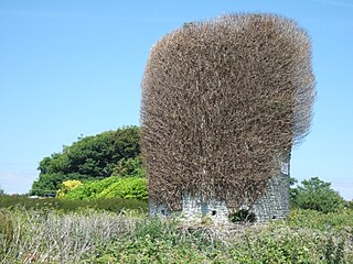
The Portland Windmills are two disused stone towers which were used as windmills from at least the early 17th century. They are located south of Easton village and the east of Weston village. The towers, which are relatively short mills with conical caps, stand approximately 135 metres apart. They have been separate Grade II Listed monuments since September 1978, and are the only historic windmill remains to survive in Dorset.

Wallsend Cove is a cove, located on the Isle of Portland, Dorset, England; part of the Jurassic Coast. It is found on the west side of Portland, further south from Mutton Cove, and situated between Southwell Business Park and Portland Bill. The cliff tops above the cove are part of the South West Coast Path.

Tar Rocks are coastal rocks on the west side of the Isle of Portland, Dorset, England. The rocks become mostly covered at high tide.
Cedar Hill is an unincorporated community and census-designated place in San Juan County, New Mexico, United States. Its population was 847 as of the 2010 census. The community is located on U.S. Route 550, near the Colorado border. Cedar Hill was originally known as Cox's Crossing. The name was chosen during a Literacy Society meeting by picking names out of a hat. A post office operated from 1892 to 1966.
