Redford, Missouri

Last updated

MOMap-doton-Redford.png

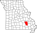
Redford is an unincorporated community in Reynolds County, Missouri, United States. [1] It is located on Misssour Route O approximately eight miles south-southeast of Centerville. Ellington is six miles to the southwest. Sinking Creek flows past the southwest side of the community. [2]

A post office called Redford has been in operation since 1890. [3] The community has the name of B. Redford, the original owner of the site. [4]

Redford was in the path of the 1925 Tri-State Tornado. [5]

Related Research Articles

<span class="mw-page-title-main">Robertsville, Missouri</span> Unincorporated community in Missouri, U.S.

Robertsville is an unincorporated community in eastern Franklin County, Missouri, United States. It is located approximately six miles (10 km) southwest of Pacific on Missouri Route O and is home to the 1,225-acre (4.96 km2) Robertsville State Park.

Black is an unincorporated community in northern Reynolds County, Missouri, United States. It is located on Route 49 on the Middle Fork of the Black River, approximately six miles north-northeast of Centerville and southwest of Johnson's Shut-Ins State Park.

<span class="mw-page-title-main">Reynolds, Reynolds County, Missouri</span> Unincorporated community in the American state of Missouri

Reynolds is an unincorporated community in western Reynolds County, Missouri, United States. It is located at the intersection of Route 72 and Missouri Route B approximately six miles southwest of Centerville.

Corridon is an unincorporated community in western Reynolds County, Missouri, United States. It is located approximately one mile south of Reynolds and seven miles southwest of Centerville.

Dagonia was an unincorporated community in western Reynolds County, in the U.S. state of Missouri. The community was on the east bank of Logan Creek along Missouri Route B. Reynolds is about seven miles to the north along Route B and Ellington lies approximately nine miles to the southeast.

Edgehill is an unincorporated community in northern Reynolds County, in the U.S. state of Missouri.

Exchange is an unincorporated community in southwest Reynolds County, in the Ozarks of southeast Missouri. The community is located along Missouri Route 106, approximately 3.5 miles west of Ellington. The community sits on the floodplain of Logan Creek.

Garwood is an unincorporated community in southern Reynolds County, in the U.S. state of Missouri. The community is on Missouri Route 34 and approximately eight miles northeast of Van Buren in adjacent Carter County.

Hadley is an unincorporated community in southern Reynolds County, in the U.S. state of Missouri. The community is in the southeast corner of the county and approximately 4.5 mile west of Leepr in adjacent Wayne County.

Helvey is an extinct town in Reynolds County, in the U.S. state of Missouri.

Hyatts Creek is a stream in southwest Iron and northeast Reynolds counties in the U.S. state of Missouri. It is a tributary of the Black River.

Monterey is an unincorporated community in northern Reynolds County, in the U.S. state of Missouri.

Munger is an unincorporated community in northeast Reynolds County, in the U.S. state of Missouri.

Ohlman is an unincorporated community in western Reynolds County, in the U.S. state of Missouri. The community is located at the intersection of Missouri routes 72 and TT approximately five miles southeast of Bunker and 2.5 miles northwest of Reynolds.

Pinkley is an extinct town in Reynolds County, in the U.S. state of Missouri.

Ruble is an unincorporated community in southern Reynolds County, in the U.S. state of Missouri. The community is on Missouri Route HH approximately seven miles southeast of Ellington. Webb Creek flows past the south side of the community to enter Clearwater Lake four miles to the east.

Smithboro is an unincorporated community in Reynolds County, in the U.S. state of Missouri.

Adelbert is an extinct town in Washington County, in the U.S. state of Missouri. The site is adjacent to the Missouri Pacific Railroad line on the west side of Mill Creek and one mile north of Mineral Point and southeast of Fountain Farm. Cadet lies approximately two miles to the northeast on Missouri Route 47.

Delbridge is an unincorporated community in southwest Washington County, in the U.S. state of Missouri. The community is on Missouri Route C seven miles west of Belgrade.

Peoria is an unincorporated community in southern Washington County, in the U.S. state of Missouri. The community is on Missouri Route JJ approximately three miles southwest of Belgrade. The Washington-Iron county line is 1.5 miles south of the community. Big River flows past the community.

References

  1. U.S. Geological Survey Geographic Names Information System: Redford, Missouri
  2. Missouri Atlas & Gazetteer, DeLorme, 1998, First edition, p. 56, ISBN   0-89933-224-2
  3. "Post Offices". Jim Forte Postal History. Retrieved December 13, 2016.
  4. "Reynolds County Place Names, 1928–1945". The State Historical Society of Missouri. Archived from the original on June 24, 2016. Retrieved December 13, 2016.
  5. "1925 Tornado". National Weather Service. Retrieved December 13, 2016.

37°19′12″N90°53′54″W / 37.32000°N 90.89833°W / 37.32000; -90.89833