The Santa Cruz Mountains are a mountain range in central and Northern California, United States, constituting a part of the Pacific Coast Ranges. They form a ridge down the San Francisco Peninsula, south of San Francisco. They separate the Pacific Ocean from the San Francisco Bay and the Santa Clara Valley, and continue south to the Central Coast, bordering Monterey Bay and ending at the Salinas Valley. The range passes through the counties of San Mateo, Santa Clara, and Santa Cruz, with the Pajaro River forming the southern boundary.

The Chihuahuan Desert is a desert ecoregion designation covering parts of northern Mexico and the southwestern United States. It occupies much of far West Texas, the middle to lower Rio Grande Valley and the lower Pecos Valley in New Mexico, and a portion of southeastern Arizona, as well as the central and northern portions of the Mexican Plateau. It is bordered on the west by the Sonoran Desert, the Colorado Plateau, and the extensive Sierra Madre Occidental range, along with northwestern lowlands of the Sierra Madre Oriental range. Its largest, continual expanse is located in Mexico, covering a large portion of the state of Chihuahua, along with portions of Coahuila, north-eastern Durango, the extreme northern part of Zacatecas, and small western portions of Nuevo León. With an area of about 501,896 km2 (193,783 sq mi), it is the largest hot desert in North America. The desert is fairly young, existing for only 8000 years.

Temperate rainforests are rainforests with coniferous or broadleaf forests that occur in the temperate zone and receive heavy rain.

The Redwood National and State Parks (RNSP) are a complex of one United States national park and three California state parks located along the coast of northern California. The combined RNSP contain Redwood National Park, Del Norte Coast Redwoods State Park, Jedediah Smith Redwoods State Park, and Prairie Creek Redwoods State Park. The parks' 139,000 acres preserve 45 percent of all remaining old-growth coast redwood forests.

Del Norte Coast Redwoods State Park is a state park of California, United States, and a component of the Redwood National and State Parks. The property is about half old-growth forest of coast redwoods and includes 8 miles (13 km) of wild Pacific coastline. The park was significantly expanded in 2002 with the 25,000-acre (10,000 ha) Mill Creek Addition. Originally established in 1925, the park is now 31,261 acres (12,651 ha). The park was designated part of the California Coast Ranges International Biosphere Reserve in 1983.

The Coast Ranges of California span 400 miles (644 km) from Del Norte or Humboldt County, California, south to Santa Barbara County. The other three coastal California mountain ranges are the Transverse Ranges, Peninsular Ranges and the Klamath Mountains.

Prairie Creek Redwoods State Park is a state park, located in Humboldt County, California, near the town of Orick and 50 miles (80 km) north of Eureka. The 14,000 acres (57 km2) park is a coastal sanctuary for old-growth Coast Redwood trees.

Malpai Borderlands is a land area along the U.S.-Mexico border. It encompasses the southeast corner of Arizona and the southwest corner of New Mexico. It is sometimes defined as including areas in the Mexican states of Chihuahua and Sonora. The Malpai is part of the Madrean Region which includes the arid and semi-arid borderlands of the United States and Mexico from California to Texas.

Climate of Peru describes the diverse climates of this large South American country with an area of 1,285,216 km2 (496,225 sq mi). Peru is located entirely in the tropics but features desert and mountain climates as well as tropical rainforests. Elevations above sea level in the country range from −37 to 6,778 m and precipitation ranges from less than 20 mm (0.79 in) annually to more than 8,000 mm (310 in). There are three main climatic regions: the Pacific Ocean coast is one of the driest deserts in the world but with some unique features; the high Andes mountains have a variety of microclimates depending on elevation and exposure and with temperatures and precipitation from temperate to polar and wet to dry; and the Amazon basin has tropical climates, mostly with abundant precipitation, along with sub-tropical climates in elevations above 1,550 m (5,090 ft).
The 3,848 acres (6.013 sq mi) Landels-Hill Big Creek Reserve located in the southern region of Big Sur, California is owned by the University of California Natural Reserve System. It is located off State Route 1 in 50 miles (80 km) south of Monterey and adjacent to the Big Creek State Marine Reserve and Big Creek State Marine Conservation Area. It is open only for approved research or educational purposes.

Orick is a census-designated place situated on the banks of the Redwood Creek in Humboldt County, California. It is located 43 miles (69 km) north of Eureka, at an elevation of 26 feet. The population was 357 at the 2010 census.
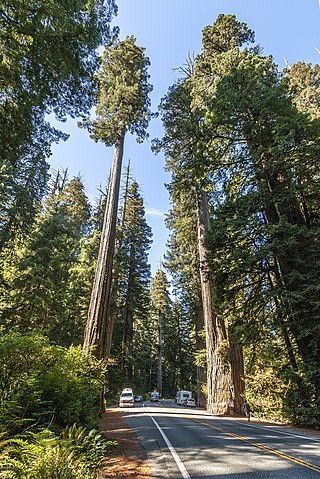
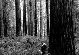
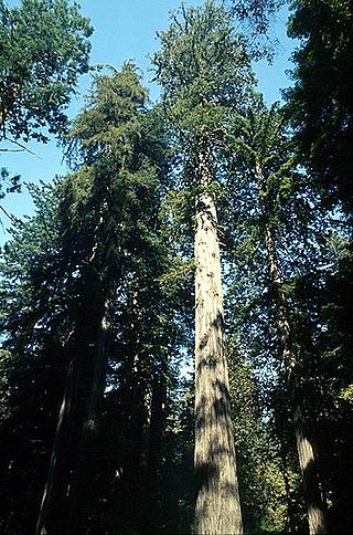
Sequoia sempervirens is the sole living species of the genus Sequoia in the cypress family Cupressaceae. Common names include coast redwood, coastal redwood and California redwood. It is an evergreen, long-lived, monoecious tree living 1,200–2,200 years or more. This species includes the tallest living trees on Earth, reaching up to 115.9 m (380.1 ft) in height and up to 8.9 m (29 ft) in diameter at breast height. These trees are also among the longest-living trees on Earth. Before commercial logging and clearing began by the 1850s, this massive tree occurred naturally in an estimated 810,000 ha along much of coastal California and the southwestern corner of coastal Oregon within the United States. Being the tallest tree species, with a small range and an extremely long lifespan, many redwoods are preserved in various state and national parks; many of the largest specimens have their own official names.
The Angelo Coast Range Reserve is located in the Northern Outer California Coast Ranges, in Mendocino County, Northern California. As part of the University of California Natural Reserve System, the mission of the Angelo Reserve is to provide protected natural areas for research and education.

The Galbreath Wildlands Preserve is a 3,670-acre (14.9 km2) nature reserve in Mendocino County, California, United States, established in 2004 in honor of Fred Burckhalter Galbreath (1901-2000). The preserve, a former sheep ranch, is located in the Outer Coast Range 17 miles (27 km) from the coast, near Yorkville. The Preserve features woodland, forest and grassland communities that lie at the edge of coastal fog influence. Lands are in the upper Rancheria sub-basin of the Navarro Watershed and contain 1st - 5th order streams. The Preserve's forests are primarily second-growth coniferous forest and hardwood.

The California Coast Ranges Biosphere Reserve was a UNESCO Biosphere reserve located along the California Coast Ranges of northern California and the San Francisco Bay area until June 2017. This biosphere reserve includes a highly diverse complex of evergreen sclerophyllous woodland, coastal, estuary and marine ecosystems.

Taymyr Nature Reserve is a Russian 'zapovednik' located in the northern lowlands of Siberia, on the Taimyr Peninsula, and on the coast of the Laptev Sea of the Arctic Ocean. The reserve includes the most northern forest of Dahurian larch in the world, and also the most northern mainland mountain range in the world. The protected area was established to protect the breeding grounds of the Red-breasted goose as well as the summer residences of wild reindeer and the biodiversity of the Lake Taymyr. The reserve is situated about 120 km east of the town of Norilsk, and 3,000 km northeast of Moscow, in the Taymyrsky Dolgano-Nenetsky District of Krasnoyarsk Krai. In 1995, the site was designated a UNESCO MAB Reserve. The reserve was formally established in 1979, and covers an area of 1,781,928 ha (6,880.06 sq mi).

Kabir Kouh Protected Area is a nature conservatory in Darreh Shahr and Badreh counties, Ilam Province, Iran. Established in October 2001, it covers an area of 179 km2 (69 sq mi) on the northern side of Kabir Kouh range between the elevations of 950 and 2790m.
There are nine national parks located in the state of California managed by the National Park Service. National parks protect significant scenic areas and nature reserves, provide educational programs, community service opportunities, and are an important part of conservation efforts in the United States. There are several other locations inside of California managed by the National Park Service, but carry other designations such as National Monuments. Many of the national parks in California are also part of national forests and National Wildlife Refuges, and contain Native American Heritage Sites and National Monuments.
The Guadalupe Island Biosphere Reserve,, is in the Pacific Ocean and part of Baja California state of Mexico. The Reserve consists of Guadalupe Island and several small islands nearby plus a large expanse of surrounding ocean. The Reserve was created by the government of Mexico on 25 April 2005 and is located 250 kilometres (160 mi) from the mainland. The Reserve is 4,770 square kilometres (1,840 sq mi) in size of which 263 square kilometres (102 sq mi) is land and the remainder is water.
The Marine West Coast Forest is a Level I ecoregion of North America designated by the Commission for Environmental Cooperation (CEC) in its North American Environmental Atlas. The region includes parts of Alaska, the Yukon, British Columbia, Washington, Oregon, and California.