Reeuwijk-Brug | |
|---|---|
Village | |
 Former town hall | |
 Reeuwijk-Brug Location in the province of South Holland in the Netherlands  Reeuwijk-Brug Location in the Netherlands | |
| Coordinates: 52°02′48″N4°43′26″E / 52.0467°N 4.7239°E | |
| Country | Netherlands |
| Province | South Holland |
| Municipality | Bodegraven-Reeuwijk |
| Area | |
• Total | 23.64 km2 (9.13 sq mi) |
| Elevation | −1.5 m (−4.9 ft) |
| Population (2021) [1] | |
• Total | 8,560 |
| • Density | 360/km2 (940/sq mi) |
| Time zone | UTC+1 (CET) |
| • Summer (DST) | UTC+2 (CEST) |
| Postal code | 2811 [1] |
| Dialing code | 0182 |
Reeuwijk-Brug is a village in the municipality of Bodegraven-Reeuwijk in the province of South Holland, the Netherlands.
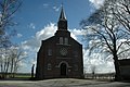
Reeuwijk-Brug is a stretched out peat excavation village from the Middle Ages which was later developed from Reeuwijk-Dorp. The Dutch Reformed church is a neoclassic aisleless church from 1863 which was built as a replacement of the 16th century church. The former town hall with bell tower was built in 1918. [3]