
Little Green Island is a granite island, with an area of 87 hectares, in south-eastern Australia. It is part of Tasmania’s Great Dog Island Group, lying in eastern Bass Strait between Flinders and Cape Barren Islands in the Furneaux Group. It is partly a conservation area, and partly private property, used for grazing livestock. The island has been degraded by repeated burning and grazing. Commercial muttonbirding took place until 1957, and recreational muttonbirding since then. The island is part of the Franklin Sound Islands Important Bird Area, identified as such by BirdLife International because it holds over 1% of the world populations of six bird species.

The Freycinet Peninsula is a large peninsula located on the eastern coast of Tasmania, Australia. The peninsula is located north of Schouten Island and is contained within the Freycinet National Park.

Schouten Island, part of the Schouten Island Group, is an island with an area of approximately 28 square kilometres (11 sq mi) lying close to the eastern coast of Tasmania, Australia, located 1.6 kilometres (0.99 mi) south of the Freycinet Peninsula and is a part of Freycinet National Park. The Paredarerme name for the island is Tiggana marraboona.

Rum Island is a granite island, with an area of 13.5 ha, just south of Preservation Island in south-eastern Australia. It is part of Tasmania’s Preservation Island Group, lying in eastern Bass Strait south-west of Cape Barren Island in the Furneaux Group. It is part of the Sydney Cove historic site.
Little Dog Island is a square, flat granite island, with an area of 83 ha, in south-eastern Australia. It is part of Tasmania’s Great Dog Island Group, lying in eastern Bass Strait between Flinders and Cape Barren Islands in the Furneaux Group. It is a game reserve. It was previously grazed, a usage now ceased. The island is part of the Franklin Sound Islands Important Bird Area, identified as such by BirdLife International because it holds over 1% of the world populations of six bird species.
South East Great Dog Islet is a small granite island, with an area of 0.6 ha, in south-eastern Australia. It is part of Tasmania’s Great Dog Island Group, lying in eastern Bass Strait between Flinders and Cape Barren Islands in the Furneaux Group. It is very close to the south-eastern end of Great Dog Island.
Tucks Reef is a small rocky island, with an area of 1.14 ha, in south-eastern Australia. It is part of Tasmania’s Vansittart Island Group, lying in eastern Bass Strait between Flinders and Cape Barren Islands in the Furneaux Group.

The St Helens Island, part of the Waterhouse Island Group, is a 51-hectare (130-acre) granite island situated in the Tasman Sea, lying close to the north-eastern coast of Tasmania, Australia.

The Nuggets is a close group of four granite islets, with a combined area of 6.76 hectares, in south-eastern Australia. They lie close to the eastern coast of Tasmania near the Freycinet Peninsula., and are near Cape Tourville, about 7 km north of Wineglass Bay and about 22 km north of Schouten Island.

The Governor Island, part of the Schouten Island Group, comprise two small granite islands with a combined area of about 2 hectares that lie close to the eastern coast of Tasmania, in south-eastern Australia. The island is located near the Freycinet Peninsula and the town of Bicheno and is a nature reserve.

Picnic Island is a small, privately owned, rocky island, with an area of about one hectare, part of the Schouten Island Group, lying close to the eastern coast of Tasmania near the Freycinet Peninsula. It is composed of sandstone overlying granite.
The Taillefer Rocks, part of the Schouten Island Group, are three small, rugged, granite islands, with a combined area of approximately 15 hectares lying close to the eastern coast of Tasmania, Australia, near the Freycinet Peninsula and lies within the Freycinet National Park.
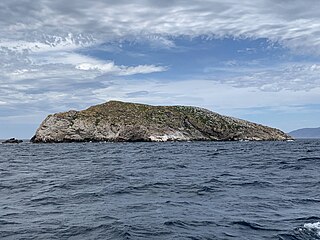
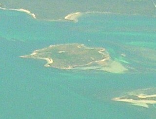
Ile des Phoques is a rugged granite island, with an area of 8 ha, part of the Schouten Island Group, lying close to the eastern coast of Tasmania, Australia near the Freycinet Peninsula.
Little Christmas Island is a small, flat, granite island, with an area of about 2 ha, in south-eastern Australia. It is part of the Schouten Island Group, lying close to the eastern coast of Tasmania near the Freycinet Peninsula. It is close to the Tasmanian mainland and, at low tide, is separated only by a shallow and narrow stretch of water.
The Ile du Nord, part of the Maria Island Group, is a small granite island with an area of approximately 10 hectares lying close to the eastern coast of Tasmania, Australia, near the Freycinet Peninsula.
The Lachlan Island, part of the Maria Island Group, is an island with an area of about 2.5 hectares lying close to the south-eastern coast of Tasmania, Australia. The island is located near the Freycinet Peninsula, situated midway between Maria Island and the Tasmanian mainland.

Sloping Island, incorporating the adjacent Sloping Reef, is an island nature reserve, with an area of 117 ha, in Tasmania in south-eastern Australia. It is part of the Sloping Island Group, lying close to the south-eastern coast of Tasmania around the Tasman and Forestier Peninsulas.

Coles Bay is an Australian town on the east Coast of Tasmania 192 km north-east of Hobart and 173 km south-east of Launceston, being the main entrance point for visitors to the Freycinet National Park.
Great Oyster Bay is a broad and sheltered bay on the east coast of Tasmania, Australia which opens onto the Tasman Sea. The Tasman Highway runs close to the West Coast of the bay with views of the granite peaks of the Hazards and Schouten Island of the Freycinet Peninsula which are incorporated in the Freycinet National Park.

King George Island is an island in south-eastern Australia. It is part of the Sloping Island Group, lying close to the south-eastern coast of Tasmania around the Tasman and Forestier Peninsulas. The island was once inhabited and farmed and contains the ruins of two buildings on its eastern side. A conservation covenant is in place on this island.
