Eritrea is located in the Horn of Africa and is bordered on the northeast and east by the Red Sea, on the west and northwest by Sudan, on the south by Ethiopia, and on the southeast by Djibouti. The country has a high central plateau that varies from 1,800 to 3,000 meters (5,906–9,843 ft) above sea level. A coastal plain, western lowlands, and some 350 islands comprise the remainder of Eritrea's land mass. Eritrea has no rivers that flow year-round.

Politics of Eritrea takes place in a framework of a single-party presidential republican totalitarian dictatorship, whereby the President is both head of state and head of government. The People's Front for Democracy and Justice is the only political party legally permitted to exist in Eritrea. The popularly elected National Assembly of 150 seats, formed in 1993 shortly after independence, elected the current president, Isaias Afewerki. There have been no general elections since its official independence in 1993. They are governed under the constitution of 1993. A new constitution was ratified in 1997, but has not been implemented.

The Bab-el-Mandeb is a strait located between Yemen on the Arabian Peninsula, and Djibouti and Eritrea in the Horn of Africa. It connects the Red Sea to the Gulf of Aden.
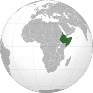
The Horn of Africa is a peninsula in Northeast Africa. It extends hundreds of kilometers into the Arabian Sea and lies along the southern side of the Gulf of Aden. The area is the easternmost projection of the African continent. Referred to in ancient and medieval times as the land of the Barbara and Habesha, the Horn of Africa denotes the region containing the countries of Djibouti, Eritrea, Ethiopia, and Somalia.

East Africa or Eastern Africa is the eastern region of the African continent, variably defined by geography. In the United Nations Statistics Division scheme of geographic regions, 20 territories make up Eastern Africa:
The regions of Eritrea are the primary geographical divisions through which Eritrea is administered. Six in total, they include the Maekel/Central, Anseba, Gash-Barka, Debub/Southern, Northern Red Sea and Southern Red Sea regions.
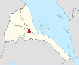
Central Region, also known as the Ma'ekel or Maakel Region, is an administrative region in central Eritrea. The region was formed on 15 April 1996, from the historical province of Hamasien. The region is located on the central plateau, and sits at an average of about 2,250 metres (7,380 ft) above sea level. It contains Asmara, the capital and largest city of Eritrea.

The Southern Red Sea Region is a region of Eritrea. It lies along the southern half of the Red Sea, and contains the coastal city of Assab. It borders the Northern Red Sea Region, and has an area of around 27,600 km2 (10,700 sq mi).

Debub Region, also known as the Southern Region, is a region of Eritrea. It lies along a portion of the national border with Ethiopia. As of 2005, the region had a population of 952,100 compared to a population of 839,700 in 2001. The net growth rate was 11.81 per cent. The total area of the province was 8000.00 km2 and the density was 119.01 persons per km2. The highest point in Eritrea, is Mount Soira 3,018 m (9,902 ft), is located in the region, situated east of Senafe. It shares borders with Central Region in the north, Zoba Northern Red Sea in the east, Gash Barka in the west and Ethiopia in the south. It is the largest region in the country by population.

The Northern Red Sea Region of Eritrea is one of the country's six regions. It lies along the northern three quarters of the Red Sea, and includes the Dahlak Archipelago and the coastal city of Massawa.
The Saho sometimes called Soho, are an ethnic Cushitic peoples inhabiting the Horn of Africa. They are principally concentrated in Eritrea, with some also living in adjacent parts of Ethiopia. They speak Saho as a mother tongue, which belongs to the Cushitic branch of the Afroasiatic family and is closely related to Afar.
Germano Nati (1946–2008) was an Eritrean politician. He joined EPLF in 1977 and, since independence, has held the following positions: member of the Central Council and Executive Committee of PFDJ, member of the National Assembly, Administrator of the Gash-Setit Province and Head of Social Affairs in the Southern Red Sea Region.

Emba Soira is the highest mountain in Eritrea. Rising 3,018 metres (9,902 ft) above sea level, it is part of the Eritrean Highlands, one side of the Great Rift Valley which cuts through Eritrea and joins the Red Sea. The mountain is situated in the southeastern part of the Debub (Southern) administrative region in central Eritrea.

Mousa Ali is a 2,021 metres (6,631 ft) stratovolcano located on the tri-point of Ethiopia, Eritrea and Djibouti. The volcano is the highest point in Djibouti. The volcano's summit is truncated by a caldera, which contains rhyolitic lava domes and lava flows. The last known eruption occurred before the Holocene era.
Central Denkalya Subregion is a subregion in the Southern Red Sea region of Eritrea. It is bordered to the northwest by the Are'eta Subregion, to the southeast by the Southern Denkalya Subregion, to the north by the Red Sea, and to the south by Ethiopia.

Southern Denkalya Subregion is a subregion in the Southern Red Sea region of Eritrea.
Eritrea, officially the State of Eritrea, is a country in the Horn of Africa, with its capital at Asmara. It is bordered by Sudan in the west, Ethiopia in the south, and Djibouti in the southeast. The northeastern and eastern parts of Eritrea have an extensive coastline along the Red Sea. The nation has a total area of approximately 117,600 km2 (45,406 sq mi), and includes the Dahlak Archipelago and several of the Hanish Islands. Its toponym Eritrea is based on the Greek name for the Red Sea, which was first adopted for Italian Eritrea in 1890.
The Danakil Alps are a highland region in Ethiopia and Eritrea with peaks over 1000 metres in height and a width varying between 40 and 70 kilometres. The alps lie to the east of the Danakil Depression and separate it from the southern Red Sea. A rift escarpment facing the Red Sea forms the eastern boundary of the range.